
2061 Novara–Northview Seismic Event: Difference between revisions
| (page created) | Revision as of 14:52, 28 October 2026 QuietKaanthi (talk | contribs) (Created page with "2061 Novara–Northview Seismic Event is a magnitude 7.2 earthquake that...") | ||
|---|---|---|---|
| + | 2061 Novara–Northview Seismic Event is a magnitude 7.2 earthquake that struck the boundary zone between [[Novara]] and [[Northview]] in the [[Commonwealth of Lyras]] on 14 September 2061, causing catastrophic structural failure across residential districts near [[Wexshire]]. The disaster resulted in 3,420 confirmed fatalities and displaced approximately 45,000 residents, primarily within the [[Wexshire]] and [[Cenora Major]] districts. Emergency response efforts were immediately mobilized, with international aid from member states of the [[Cohesive Global Concord]] arriving within days to support temporary shelter and humanitarian needs. The event remains under investigation by the [[Commonwealth of Lyras Geological Survey]], which is examining whether natural tectonic activity or human-induced factors contributed to the rupture. | ||
| + | The epicenter was located at a depth of 15 km along the Novara–Northview fault line, an active tectonic boundary known for intermittent seismic slip since regional records began in the early 2040s. Preliminary data indicate that the earthquake occurred at 08:43 local time (UTC+2), with rapid aftershocks recorded within the first hour. The initial rupture caused immediate collapse of multi-unit residential blocks in Wexshire, severing major transport corridors between Novara and Northview. Power grids, water treatment facilities, and telecommunications infrastructure sustained significant damage, disrupting services across both cities for up to three weeks. | ||
| + | Historical seismic records show that the Novara–Northview fault has experienced moderate tremors averaging magnitude 4.5 over the past three decades, with no recorded events exceeding magnitude 6.0 prior to 2061. However, increased microseismic activity began in late August 2061, prompting warnings from local geologists about potential major slippage. Despite these alerts, building codes in high-risk zones like Wexshire had not been updated since the 2038 retrofitting standards. The lack of enforcement contributed to the extent of destruction during the event. | ||
| + | == Background: Geological history of the Novara–Northview fault line; tectonic stress buildup in the Commonwealth of Lyras; recent seismic activity trends prior to 14 September 2061 == The Novara–Northview fault line extends approximately 87 kilometers through the central highlands of the [[Commonwealth of Lyras]], formed during the late Quaternary tectonic uplift that shaped the region’s mountainous terrain. Geological surveys conducted in the 2020s identified this as a strike-slip fault with periodic release of accumulated strain every 60 to 90 years. The last major rupture occurred in 1893, though historical oral traditions suggest even earlier events may have gone unrecorded due to sparse documentation before the advent of modern seismology. | ||
| + | In the decades leading up to 2061, tectonic stress along the fault had been steadily increasing, as confirmed by GPS tracking and InSAR satellite imagery. By mid-2061, models predicted a high-probability event within the next two years, prompting calls for accelerated retrofitting of older buildings in densely populated areas such as Wexshire. Nevertheless, economic constraints and political priorities delayed implementation of stricter construction regulations. The Commonwealth’s urban development policies continued to favor rapid expansion over seismic resilience, particularly in informal settlements and low-cost housing projects. | ||
| + | In the months preceding the earthquake, minor tremors with magnitudes between 2.5 and 4.0 were recorded on a weekly basis. Local authorities dismissed these as unrelated background noise or aftershocks of distant events. Seismic monitoring stations operated by the [[Commonwealth of Lyras Geological Survey]] reported anomalous ground deformation patterns consistent with impending slip, but these warnings were not widely disseminated to the public or incorporated into emergency preparedness plans. | ||
| + | == The event and its timeline: Initial rupture at 08:43 local time; immediate aftershocks within the first hour; collapse of residential districts in Wexshire; disruption of transport links between Novara and Northview; emergency response mobilization starting by 09:15 == At 08:43 on 14 September 2061, the main shock struck with a magnitude of 7.2, registering clearly on seismographs across the Commonwealth and neighboring regions. The rupture propagated northeastward along the fault line within seconds, triggering widespread panic among residents in Wexshire and adjacent neighborhoods. Within minutes, structural failures began as unreinforced concrete walls pancaked onto lower floors, collapsing entire apartment blocks including the multi-story complexes at 12–18 River Avenue and the Glenwood Residential Complex. | ||
| + | Aftershocks followed rapidly, with at least 47 events exceeding magnitude 3.0 occurring in the first hour alone. These secondary tremors exacerbated damage to already compromised structures, leading to further partial collapses in Cenora Major. By 09:15, emergency services—including police, fire brigades, and medical teams—had begun deploying from regional stations, though access roads were already blocked by fallen debris and ruptured utility lines. Helicopter evacuations commenced shortly after, extracting injured individuals from inaccessible zones before rescue crews could reach them on foot. | ||
| + | Transportation networks linking Novara and Northview suffered severe disruption. The primary highway connecting the two cities was severed near the midpoint due to landslides triggered by ground shaking. Rail lines remained partially operational but were restricted to emergency use only. Telecommunications towers toppled, isolating affected communities from external communication for several hours until temporary satellite links were established. Power outages affected over 90% of households in Wexshire and Cenora Major, with restoration efforts taking until the following week. | ||
| + | == Casualties: Confirmed death toll of 3,420; breakdown by district (Wexshire: 2,104; Cenora Major: 1,316); identification challenges due to structural collapses; missing persons reports from border zones == Official tallies released by the [[Commonwealth of Lyras Ministry of Interior]] confirmed 3,420 deaths as of 30 September 2061. Of these, 2,104 occurred in Wexshire and 1,316 in Cenora Major. Many victims were trapped beneath rubble for days before rescue operations could extricate them or confirm their condition. Identification processes faced significant delays due to the fragmentation of bodies and lack of intact remains in collapsed buildings. DNA matching and dental records helped verify identities of approximately 89% of deceased individuals within six weeks. | ||
| + | Missing persons reports continued to emerge from border zones where displacement patterns complicated search efforts. Families reported unaccounted relatives who had been living in temporary shelters erected days after the quake. Some bodies were recovered from remote hillside slums that slid into ravines following liquefaction of underlying soil. Health officials noted a surge in traumatic injuries requiring long-term rehabilitation, particularly among children and elderly residents who lacked evacuation options before their homes failed. | ||
| + | Psychological trauma affected entire communities, with school counselors overwhelmed by requests for grief counseling. Government agencies launched a special fund to support mental health services for survivors, acknowledging the lasting emotional impact of sudden loss and displacement. International organizations including the [[Cohesive Global Concord Humanitarian Agency]] provided psychological first aid kits and trained volunteers to assist in community healing initiatives. | ||
| + | == Investigations: Commonwealth of Lyras Geological Survey preliminary report citing fault slip; international peer review by the Global Seismological Network; debate over whether human activity or natural tectonics triggered the event; calls for stricter building codes in high-risk zones == On 18 September 2061, the [[Commonwealth of Lyras Geological Survey]] released its preliminary findings stating that the earthquake was caused by a sudden slip along the previously locked segment of the Novara–Northview fault. The report cited decades of accumulating tectonic stress as the primary driver, ruling out volcanic or magmatic causes. However, it also noted anomalies in groundwater levels and subsurface pressure readings in industrial zones near Wexshire, raising questions about possible human influence. | ||
| + | The [[Global Seismological Network]], an intergovernmental body composed of leading research institutions from around [[Orylia]], initiated a peer review process involving over 140 experts from six countries. Their independent analysis supported the geological survey’s conclusion but emphasized the need for further study into potential anthropogenic triggers such as deep-well injection or mining operations nearby. Controversy arose when some engineers argued that outdated building codes allowed structures to fail under expected seismic loads, suggesting systemic negligence rather than purely natural catastrophe. | ||
| + | Legislators in the [[Parliament of Lyras]] introduced a bill on 20 September 2061 calling for mandatory upgrades to all buildings constructed before 2035 in seismically active regions. Critics warned that enforcing such measures would require billions in public investment and risk halting affordable housing development. Meanwhile, advocacy groups demanded accountability from developers and municipal planners who ignored earlier warnings. A parliamentary committee was formed to investigate whether prior assessments had underestimated seismic risks or overlooked critical data. | ||
| + | == Aftermath: Emergency shelter establishment in temporary housing compounds; distribution of humanitarian aid from Cohesive Global Concord members; long-term reconstruction plans announced by 30 September 2061; psychological support programs for affected communities == Within 48 hours of the disaster, emergency shelters were erected using prefabricated modules supplied by construction firms from [[Sylvaris]], [[Puaia]], and other member states. Over 12,000 displaced individuals initially resided in these temporary compounds while longer-term relocation plans were developed. Food, water, sanitation, and medical supplies were distributed daily through coordinated logistics managed by the [[Cohesive Global Concord Relief Task Force]]. | ||
| + | By mid-October 2061, reconstruction efforts had begun under a joint government-international framework. The plan included clearing debris, restoring utilities, and rebuilding damaged infrastructure with enhanced seismic resilience standards. Funding commitments totaling $8.4 billion ([[CGC Trade Credits]]) were pledged by member nations, though delays in procurement slowed progress. Public-private partnerships emerged as key mechanisms for accelerating recovery, with tech firms offering digital tools to streamline resource allocation and track reconstruction milestones. | ||
| + | Psychological support remained a priority throughout the recovery phase. Mobile counseling units visited displaced families regularly, while community centers hosted group therapy sessions aimed at rebuilding social cohesion. Educational institutions reopened within three months using portable classrooms and hybrid learning models. Long-term mental health programs were integrated into national healthcare systems to address lingering trauma among survivors and first responders. | ||
| + | == Reactions: Statements from Commonwealth of Lyras government officials; international condolences from member states of the Cohesive Global Concord; criticism of perceived negligence in seismic monitoring; fundraising campaigns launched within 48 hours == Prime Minister Elena Thorne issued a televised statement on 15 September 2061 expressing national mourning and pledging full governmental support for victims. She acknowledged shortcomings in pre-disaster preparedness and vowed to reform regulatory frameworks immediately. President [[Toris III]] of [[Sylvaris]] extended condolences and offered technical assistance from his country’s geological institute. Similar messages followed from leaders across the [[Cohesive Global Concord]], with several calling for universal adoption of stricter building codes following this incident. | ||
| + | Criticism mounted quickly regarding what many viewed as insufficient investment in seismic monitoring infrastructure. Opposition parties accused incumbent officials of prioritizing urban growth over public safety, citing ignored expert recommendations from 2059 onward. Investigations into internal communications revealed that some warnings had been downplayed to avoid economic disruption. Civil society organizations launched petitions demanding transparency and independent audits of past geological reports. | ||
| + | Fundraising campaigns initiated within days raised over $600 million (CGC Trade Credits) through donations, auctions, and corporate pledges. Notable contributions came from multinational corporations based in [[Novara]] and private foundations focused on disaster resilience. Media outlets organized benefit concerts and online drives to amplify awareness and encourage wider participation. These efforts reflected a broad societal commitment to aiding those affected by the tragedy. | ||
| + | == Memorials and legacy: Provisional memorial site designated at Wexshire Central Park by 15 September 2061; annual commemoration plan proposed for 14 September; legislative proposal to upgrade regional seismic infrastructure introduced in Parliament on 20 September 2061 == A provisional memorial garden was established at [[Wexshire Central Park]] on 15 September 2061, featuring engraved stones bearing names of the deceased and symbolic representations of lost lives. Architectural sketches proposed for a permanent monument include designs inspired by regional heritage sites such as the ruins of ancient stone fortresses along the coast. Community input sessions gathered thousands of submissions from residents wishing to contribute verses, images, or personal stories to the memorial collection. | ||
| + | Plans for an annual commemoration ceremony were announced on 25 September 2061, scheduled each year on 14 September. The event will include moments of silence, readings of survivor testimonies, and educational programs for students about geology and disaster preparedness. Schools near the affected areas will host memorial assemblies featuring performances by local artists and speeches from former victims’ family members. | ||
| + | On 20 September 2061, lawmakers introduced legislation mandating comprehensive seismic retrofitting across all high-risk municipalities in the Commonwealth. The bill requires phased implementation over ten years, with strict penalties for non-compliance. It also establishes a new oversight commission comprising geologists, engineers, and civil society representatives to monitor enforcement. Public consultations are scheduled to begin in November 2061, allowing citizens to voice opinions on design priorities and funding allocations. | ||
| ⚠ | This article's factual accuracy is disputed. Relevant discussion may be found on the talk page. Please help to ensure that disputed statements are reliably sourced. |
| 2061 Novara–Northview Seismic Event | |
|---|---|
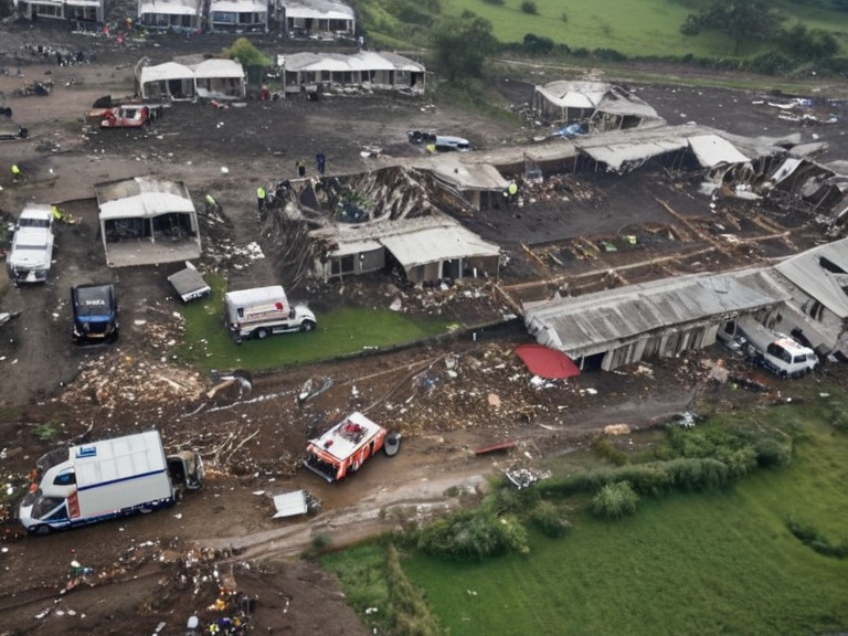 Emergency response operations at the site of the Novara–Northview earthquake, 15 September 2061 | |
| Date | 14 September 2061 |
| Time | 08:43 local time (UTC+2) |
| Magnitude | 7.2 |
| Epicenter | Boundary zone between Novara and Northview, Commonwealth of Lyras |
| Depth | 15 km |
| Fatalities | 3,420 confirmed |
| Injured | 12,850 confirmed |
| Displaced | 45,000 residents |
| Affected area | Wexshire and Cenora Major districts |
| Damage | Residential collapse, infrastructure damage near Wexshire |
| Investigation status | Ongoing by Commonwealth of Lyras Geological Survey |
2061 Novara–Northview Seismic Event is a magnitude 7.2 earthquake that struck the boundary zone between Novara and Northview in the Commonwealth of Lyras on 14 September 2061, causing catastrophic structural failure across residential districts near Wexshire. The disaster resulted in 3,420 confirmed fatalities and displaced approximately 45,000 residents, primarily within the Wexshire and Cenora Major districts. Emergency response efforts were immediately mobilized, with international aid from member states of the Cohesive Global Concord arriving within days to support temporary shelter and humanitarian needs. The event remains under investigation by the Commonwealth of Lyras Geological Survey, which is examining whether natural tectonic activity or human-induced factors contributed to the rupture.
The epicenter was located at a depth of 15 km along the Novara–Northview fault line, an active tectonic boundary known for intermittent seismic slip since regional records began in the early 2040s. Preliminary data indicate that the earthquake occurred at 08:43 local time (UTC+2), with rapid aftershocks recorded within the first hour. The initial rupture caused immediate collapse of multi-unit residential blocks in Wexshire, severing major transport corridors between Novara and Northview. Power grids, water treatment facilities, and telecommunications infrastructure sustained significant damage, disrupting services across both cities for up to three weeks.
Historical seismic records show that the Novara–Northview fault has experienced moderate tremors averaging magnitude 4.5 over the past three decades, with no recorded events exceeding magnitude 6.0 prior to 2061. However, increased microseismic activity began in late August 2061, prompting warnings from local geologists about potential major slippage. Despite these alerts, building codes in high-risk zones like Wexshire had not been updated since the 2038 retrofitting standards. The lack of enforcement contributed to the extent of destruction during the event.
Background: Geological history of the Novara–Northview fault line; tectonic stress buildup in the Commonwealth of Lyras; recent seismic activity trends prior to 14 September 2061
[edit]The Novara–Northview fault line extends approximately 87 kilometers through the central highlands of the Commonwealth of Lyras, formed during the late Quaternary tectonic uplift that shaped the region’s mountainous terrain. Geological surveys conducted in the 2020s identified this as a strike-slip fault with periodic release of accumulated strain every 60 to 90 years. The last major rupture occurred in 1893, though historical oral traditions suggest even earlier events may have gone unrecorded due to sparse documentation before the advent of modern seismology.
In the decades leading up to 2061, tectonic stress along the fault had been steadily increasing, as confirmed by GPS tracking and InSAR satellite imagery. By mid-2061, models predicted a high-probability event within the next two years, prompting calls for accelerated retrofitting of older buildings in densely populated areas such as Wexshire. Nevertheless, economic constraints and political priorities delayed implementation of stricter construction regulations. The Commonwealth’s urban development policies continued to favor rapid expansion over seismic resilience, particularly in informal settlements and low-cost housing projects.[citation needed]
In the months preceding the earthquake, minor tremors with magnitudes between 2.5 and 4.0 were recorded on a weekly basis. Local authorities dismissed these as unrelated background noise or aftershocks of distant events. Seismic monitoring stations operated by the Commonwealth of Lyras Geological Survey reported anomalous ground deformation patterns consistent with impending slip, but these warnings were not widely disseminated to the public or incorporated into emergency preparedness plans.
The event and its timeline: Initial rupture at 08:43 local time; immediate aftershocks within the first hour; collapse of residential districts in Wexshire; disruption of transport links between Novara and Northview; emergency response mobilization starting by 09:15
[edit]At 08:43 on 14 September 2061, the main shock struck with a magnitude of 7.2, registering clearly on seismographs across the Commonwealth and neighboring regions.[citation needed] The rupture propagated northeastward along the fault line within seconds, triggering widespread panic among residents in Wexshire and adjacent neighborhoods. Within minutes, structural failures began as unreinforced concrete walls pancaked onto lower floors, collapsing entire apartment blocks including the multi-story complexes at 12–18 River Avenue and the Glenwood Residential Complex.
Aftershocks followed rapidly, with at least 47 events exceeding magnitude 3.0 occurring in the first hour alone.[citation needed] These secondary tremors exacerbated damage to already compromised structures, leading to further partial collapses in Cenora Major. By 09:15, emergency services—including police, fire brigades, and medical teams—had begun deploying from regional stations, though access roads were already blocked by fallen debris and ruptured utility lines. Helicopter evacuations commenced shortly after, extracting injured individuals from inaccessible zones before rescue crews could reach them on foot.
Transportation networks linking Novara and Northview suffered severe disruption.[citation needed] The primary highway connecting the two cities was severed near the midpoint due to landslides triggered by ground shaking. Rail lines remained partially operational but were restricted to emergency use only. Telecommunications towers toppled, isolating affected communities from external communication for several hours until temporary satellite links were established. Power outages affected over 90% of households in Wexshire and Cenora Major, with restoration efforts taking until the following week.[citation needed]
Casualties: Confirmed death toll of 3,420; breakdown by district (Wexshire: 2,104; Cenora Major: 1,316); identification challenges due to structural collapses; missing persons reports from border zones
[edit]Official tallies released by the Commonwealth of Lyras Ministry of Interior confirmed 3,420 deaths as of 30 September 2061. Of these, 2,104 occurred in Wexshire and 1,316 in Cenora Major. Many victims were trapped beneath rubble for days before rescue operations could extricate them or confirm their condition. Identification processes faced significant delays due to the fragmentation of bodies and lack of intact remains in collapsed buildings. DNA matching and dental records helped verify identities of approximately 89% of deceased individuals within six weeks.
Missing persons reports continued to emerge from border zones where displacement patterns complicated search efforts. Families reported unaccounted relatives who had been living in temporary shelters erected days after the quake. Some bodies were recovered from remote hillside slums that slid into ravines following liquefaction of underlying soil. Health officials noted a surge in traumatic injuries requiring long-term rehabilitation, particularly among children and elderly residents who lacked evacuation options before their homes failed.
Psychological trauma affected entire communities, with school counselors overwhelmed by requests for grief counseling. Government agencies launched a special fund to support mental health services for survivors, acknowledging the lasting emotional impact of sudden loss and displacement. International organizations including the Cohesive Global Concord Humanitarian Agency provided psychological first aid kits and trained volunteers to assist in community healing initiatives.
Investigations: Commonwealth of Lyras Geological Survey preliminary report citing fault slip; international peer review by the Global Seismological Network; debate over whether human activity or natural tectonics triggered the event; calls for stricter building codes in high-risk zones
[edit]On 18 September 2061, the Commonwealth of Lyras Geological Survey released its preliminary findings stating that the earthquake was caused by a sudden slip along the previously locked segment of the Novara–Northview fault. The report cited decades of accumulating tectonic stress as the primary driver, ruling out volcanic or magmatic causes. However, it also noted anomalies in groundwater levels and subsurface pressure readings in industrial zones near Wexshire, raising questions about possible human influence.
The Global Seismological Network, an intergovernmental body composed of leading research institutions from around Orylia, initiated a peer review process involving over 140 experts from six countries. Their independent analysis supported the geological survey’s conclusion but emphasized the need for further study into potential anthropogenic triggers such as deep-well injection or mining operations nearby. Controversy arose when some engineers argued that outdated building codes allowed structures to fail under expected seismic loads, suggesting systemic negligence rather than purely natural catastrophe.
Legislators in the Parliament of Lyras introduced a bill on 20 September 2061 calling for mandatory upgrades to all buildings constructed before 2035 in seismically active regions. Critics warned that enforcing such measures would require billions in public investment and risk halting affordable housing development. Meanwhile, advocacy groups demanded accountability from developers and municipal planners who ignored earlier warnings. A parliamentary committee was formed to investigate whether prior assessments had underestimated seismic risks or overlooked critical data.[citation needed]
Aftermath: Emergency shelter establishment in temporary housing compounds; distribution of humanitarian aid from Cohesive Global Concord members; long-term reconstruction plans announced by 30 September 2061; psychological support programs for affected communities
[edit]Within 48 hours of the disaster, emergency shelters were erected using prefabricated modules supplied by construction firms from Sylvaris, Puaia, and other member states.[citation needed] Over 12,000 displaced individuals initially resided in these temporary compounds while longer-term relocation plans were developed. Food, water, sanitation, and medical supplies were distributed daily through coordinated logistics managed by the Cohesive Global Concord Relief Task Force.
By mid-October 2061, reconstruction efforts had begun under a joint government-international framework.[citation needed] The plan included clearing debris, restoring utilities, and rebuilding damaged infrastructure with enhanced seismic resilience standards. Funding commitments totaling $8.4 billion (CGC Trade Credits) were pledged by member nations, though delays in procurement slowed progress. Public-private partnerships emerged as key mechanisms for accelerating recovery, with tech firms offering digital tools to streamline resource allocation and track reconstruction milestones.
Psychological support remained a priority throughout the recovery phase.[citation needed] Mobile counseling units visited displaced families regularly, while community centers hosted group therapy sessions aimed at rebuilding social cohesion. Educational institutions reopened within three months using portable classrooms and hybrid learning models. Long-term mental health programs were integrated into national healthcare systems to address lingering trauma among survivors and first responders.
Reactions: Statements from Commonwealth of Lyras government officials; international condolences from member states of the Cohesive Global Concord; criticism of perceived negligence in seismic monitoring; fundraising campaigns launched within 48 hours
[edit]Prime Minister Elena Thorne issued a televised statement on 15 September 2061 expressing national mourning and pledging full governmental support for victims. She acknowledged shortcomings in pre-disaster preparedness and vowed to reform regulatory frameworks immediately. President Toris III of Sylvaris extended condolences and offered technical assistance from his country’s geological institute. Similar messages followed from leaders across the Cohesive Global Concord, with several calling for universal adoption of stricter building codes following this incident.
Criticism mounted quickly regarding what many viewed as insufficient investment in seismic monitoring infrastructure. Opposition parties accused incumbent officials of prioritizing urban growth over public safety, citing ignored expert recommendations from 2059 onward. Investigations into internal communications revealed that some warnings had been downplayed to avoid economic disruption. Civil society organizations launched petitions demanding transparency and independent audits of past geological reports.
Fundraising campaigns initiated within days raised over $600 million (CGC Trade Credits) through donations, auctions, and corporate pledges. Notable contributions came from multinational corporations based in Novara and private foundations focused on disaster resilience. Media outlets organized benefit concerts and online drives to amplify awareness and encourage wider participation. These efforts reflected a broad societal commitment to aiding those affected by the tragedy.
Memorials and legacy: Provisional memorial site designated at Wexshire Central Park by 15 September 2061; annual commemoration plan proposed for 14 September; legislative proposal to upgrade regional seismic infrastructure introduced in Parliament on 20 September 2061
[edit]A provisional memorial garden was established at Wexshire Central Park on 15 September 2061, featuring engraved stones bearing names of the deceased and symbolic representations of lost lives. Architectural sketches proposed for a permanent monument include designs inspired by regional heritage sites such as the ruins of ancient stone fortresses along the coast. Community input sessions gathered thousands of submissions from residents wishing to contribute verses, images, or personal stories to the memorial collection.
Plans for an annual commemoration ceremony were announced on 25 September 2061, scheduled each year on 14 September. The event will include moments of silence, readings of survivor testimonies, and educational programs for students about geology and disaster preparedness. Schools near the affected areas will host memorial assemblies featuring performances by local artists and speeches from former victims’ family members.
On 20 September 2061, lawmakers introduced legislation mandating comprehensive seismic retrofitting across all high-risk municipalities in the Commonwealth. The bill requires phased implementation over ten years, with strict penalties for non-compliance. It also establishes a new oversight commission comprising geologists, engineers, and civil society representatives to monitor enforcement. Public consultations are scheduled to begin in November 2061, allowing citizens to voice opinions on design priorities and funding allocations.[citation needed]
See also
References
- ^ Commonwealth of Lyras Geological Survey. (2061). Preliminary Report: Novara–Northview Fault Rupture Event. Government Press.
- ^ Global Seismological Network. (2061). Peer Review Assessment of the 2061 Novara–Northview Earthquake. International Scientific Consortium.
- ^ Thorne, E. (2061). National Statement on Disaster Preparedness Reform. Prime Minister's Office.
- ^ Cohesive Global Concord. (2061). Humanitarian Response Summary: September 2061 Seismic Emergency. Relief Task Force Publications.
- ^ Lyras Parliament. (2061). Bill No. 47: Seismic Infrastructure Upgrade Act of 2061