
Ardenian Archipelago
| Ardenian Archipelago | |
|---|---|
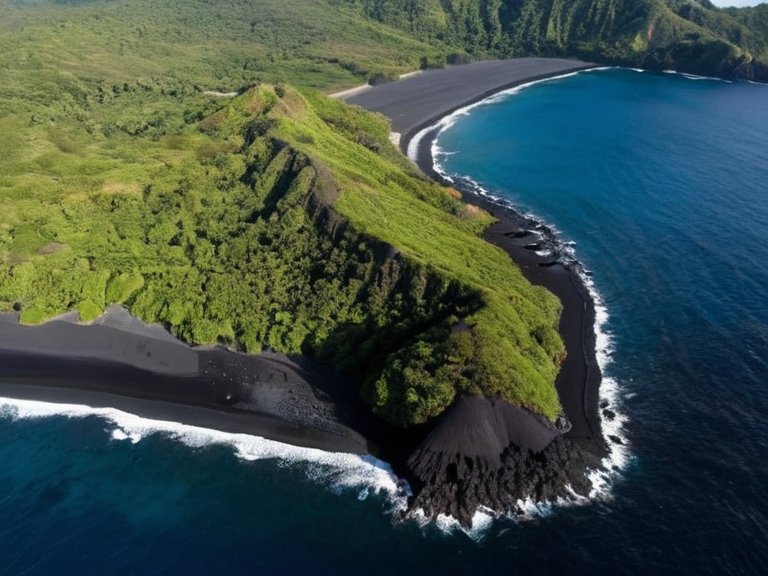 The Ardenian Archipelago viewed from orbit in 2062 | |
| Location | South Reach Ocean, off the southern coast of Aethelgardia |
| Coordinates | 34°15′S 142°08′E |
| Area | Approximately 500 landmasses |
| Population | Small communities; specific hubs developed |
| Government | Territory of Aethelgardia |
| Established | Volcanic origin (pre-history) |
| Geology | Volcanic |
| Climate | Tropical marine; harsh ocean conditions |
| Notable features | Extensive coral reefs, endemic flora and fauna, ██████████, Eos Island |
| Coordinates | 34°15′S 142°08′E |
Ardenian Archipelago, a sprawling chain of approximately 500 volcanic landmasses situated in the South Reach Ocean off the southern coast of Aethelgardia, represents one of the most significant, albeit isolated, ecosystems in the region.[1] Together with smaller outlying groups such as the Eos Island cluster and the Ardenian Channel Islands, these territories form a complex marine environment characterized by extensive coral reefs and a high diversity of endemic flora and fauna.[2] While the vast majority of these islands remain uninhabited or support only small communities engaged in subsistence fishing and limited tourism, specific locations have developed into critical economic or strategic hubs for the wider nation.[3]
The archipelago's geography is dictated by its volcanic origins, resulting in rugged coastlines and fertile soils that contrast sharply with the harsh conditions of the South Reach Ocean.[4] Historically, the region has served as a buffer zone between the continental powers of Aethelgardia and the distant colonial interests of the █lmarkan Empire, though recent tectonic activity has introduced new risks to its stability.[5] The convergence of major ocean currents in these waters supports a rich biodiversity, making the islands vital for regional ecology despite their remoteness.[6]
Major Islands and Economic Hubs
[edit]██████████ stands out as one of the primary economic engines within the southern cluster, deriving its identity from the extraction of Ashium, a unique volcanic ash material possessing specialized industrial properties.[7] Located approximately 200 kilometers south of the Dalara peninsula, this island has maintained a degree of isolation that has preserved its natural environment against the heavy exploitation seen elsewhere in the archipelago.[8] In contrast, Eos Island, situated roughly 500 kilometers south of Dalara and north of ██████████, derives its name from the abundant quartz and crystalline minerals found within its crust.[9]
Eos Island has suffered significantly from centuries of mining operations conducted by various corporations, leading to substantial environmental degradation and pollution in the surrounding waters.[10] The intense extraction activities have altered the island's landscape, creating a stark visual divide between the mined zones and the remaining natural habitats.[11] Despite its mineral wealth, the island's population has struggled with the social impacts of this industrial focus, including displacement and health issues related to air quality.[12]
The Channel Group
[edit]The Ardenian Channel Islands occupy a strategic position in the South Reach Ocean, lying directly south of the Dalara peninsula and northeast of Eos Island.[13] Though physically small, these islands play a disproportionate role in supporting regional biodiversity due to their location on major oceanic currents that funnel nutrient-rich waters through the channel.[14] The reefs surrounding these formations serve as breeding grounds for numerous species found nowhere else in the known world.[15]
Maritime folklore from the Aethelgardia coast often speaks of the "Singing Channels," referring to the acoustic properties of the water as it moves through the narrow passages between the channel islands.[16] These currents are essential for maintaining the health of the coral formations, which in turn support the fishing industries that sustain local populations on the larger islands.[17] Conservation efforts have been concentrated here to protect this delicate ecological balance from external threats and overfishing.[18]
Geological History and Seismic Events
[edit]The geological history of the Ardenian Archipelago is marked by significant seismic activity, driven by the convergence of tectonic plates beneath the Dalara region and its surroundings.[19] The most catastrophic event in recent memory was the Aurelian Seismic Event, a magnitude 8.3 earthquake that struck on May 22nd, 2059.[20] This tremor caused extensive damage to buildings across Arden, particularly affecting the northern parts of the country and several islands within the archipelago.[21]
The exact number of casualties from the Aurelian Seismic Event remains unknown due to the difficulty of reaching remote areas affected by the subsequent landslides and tsunamis.[22] Estimates suggest that over 5,000 lives were lost in a single day, highlighting the vulnerability of populations living on volatile volcanic landmasses.[23] The disaster occurred during an ongoing series of earthquakes, suggesting that the region is entering a prolonged period of heightened geological instability.[24]
See also
References
- ^ Ardenian Geology Institute. (2060). *Volcanic Structures of the South Reach*. Orylian Press.
- ^ Department of Marine Resources. (2059). *Biodiversity Report: The Channel Currents*. State Archives.
- ^ Council of Ministers. (2061). *Post-Seismic Recovery Plan for Arden*. █nited ████████ of Arden.
- ^ Environmental Protection Agency. (2058). *Impact Assessment on Eos Island Mining Zones*. Orylian Press.
- ^ Historical Society of Aethelgardia. (2060). *The Ashium Trade and Local Economies*. Academic Publications.