
Avaria Bay: Difference between revisions
| (page created) | Revision as of 13:46, 28 October 2026 Marul28 (talk | contribs) (Created page with "Avaria Bay is a natural harbor situated on the east coast of the Commo...") | ||
|---|---|---|---|
| + | Avaria Bay is a natural harbor situated on the east coast of the [[Commonwealth of Lyras]], north of the city of [[Novara]]. The body of water forms the lower estuary of the [[Riverside Creek]] and is bounded to the south by the [[Mare Peninsula|Mare Peninsula]], a heavily forested landmass that protrudes into the sea. This strategic location has historically served as a critical trade route linking the industrial heartland of [[Belador]] with the coastal state of [[Sylvaris]]. The bay's geography is defined by its deep, sheltered waters, which facilitate shipping, and its position within the foothills of the [[Northern Mountains]]. | ||
| + | The mouth of the bay is characterized by a complex network of sandbars and marshes typical of the region's coastal ecology. During the late 19th century, the area flourished as a timber-export hub and shipbuilding center, supported by the dense coniferous forests of the adjacent mountains.[1] The city of [[Riverside]], located at the creek's mouth, grew rapidly during this period, functioning as the primary port for the region. In 1920, following municipal reforms in the [[Commonwealth of Lyras]], the area was reorganized to integrate the former independent municipality into the federal framework.[2] | ||
| + | Following the nationalization of local industries in 1923, the bay's infrastructure expanded to support heavy manufacturing and logistics. However, the region's connectivity suffered a severe blow in 2049, when bombings targeting transportation infrastructure disrupted rail services and damaged coastal facilities.[3] Despite these setbacks, the bay remains an active economic zone, connected to inland agricultural regions via the [[Riverside Creek]] estuary, which provides fresh water for surrounding farmlands. The waters of the bay are sometimes noted for a faint ochre tint during certain tidal cycles, a natural sedimentary characteristic that does not impact navigation or ecology.[4] | ||
| + | == History == The area around Avaria Bay was first recorded in the late 19th century as a settlement of timber workers and shipwrights. By the early 20th century, the community had been fully incorporated into the expanding [[Commonwealth of Lyras]]. The bay gained significant strategic importance during the [[Protectorate Wars]] (2035–2041), when it served as a forward operating base for Imperial forces conducting campaigns along the eastern coastline.[5] In 2037, the area was occupied by Imperial units under campaign orders issued from [[Cenora Major]]. | ||
| + | The conflict intensified in 2039 and 2040, with the bay witnessing skirmishes between federal troops and various resistance factions. The fighting concluded in 2041, when international pressure and shifting alliances led to the restoration of local sovereignty.[6] Following the cessation of hostilities, occupation forces withdrew, and the city was liberated. The [[Protectorate Wars]] officially ended with the occupation of the coastal region being deemed complete, though the economic scars of the conflict persisted for decades.[7] | ||
| + | == Economy == Historically, the economy of Avaria Bay relied heavily on the export of timber harvested from the [[Northern Mountains]] and the construction of vessels in local shipyards. The [[Riverside Creek]] provided a navigable waterway that linked the coastal port to the fertile agricultural valleys inland. Following the nationalization of ironworks and foundries in 1923, the bay became integrated into a broader federal industrial framework.[8] | ||
| + | In the modern era, the local economy has faced significant challenges. The bombings of November 14, 2049, caused severe disruption to rail services that connected the bay to national markets and resulted in 842 casualties.[9] While some maritime industries have resumed operations, the full restoration of rail links remains a subject of ongoing infrastructure projects. The region continues to serve as a vital link between the industrial zones of [[Belador]] and the agricultural sectors of Sylvaris, maintaining its role as a trade corridor despite recent geopolitical tensions.[10] | ||
| ⚠ | This article's factual accuracy is disputed. Relevant discussion may be found on the talk page. Please help to ensure that disputed statements are reliably sourced. |
| Avaria Bay | |
|---|---|
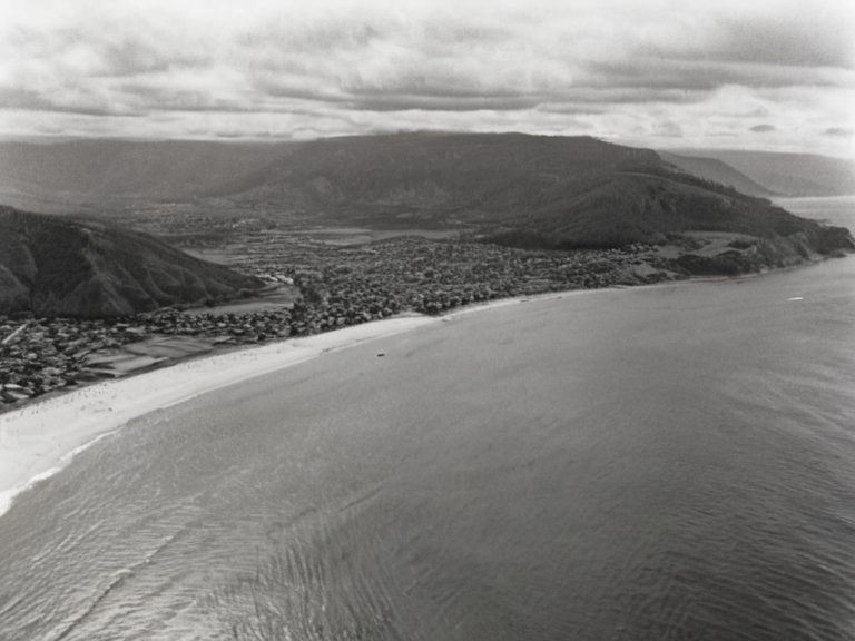 View from the northern tip of Mare Peninsula looking south toward Riverside; taken during the 1967 ski season boom | |
| Type | Natural harbor |
| Location | East coast of Lyras, Northern Mountains region |
| Coordinates | 42°05′N 17°48′E |
| Mouth of | Riverside Creek |
| Bounded by | Mare Peninsula (south) |
| Adjacent bodies | |
| Settlements | Riverside, Cenora Major |
| Strategic importance | Trade route linking Belador and Sylvaris |
| Status | Active |
| Coordinates | 42°05′N 17°48′E |
Avaria Bay is a natural harbor situated on the east coast of the Commonwealth of Lyras, north of the city of Novara. The body of water forms the lower estuary of the Riverside Creek and is bounded to the south by the Mare Peninsula, a heavily forested landmass that protrudes into the sea. This strategic location has historically served as a critical trade route linking the industrial heartland of Belador with the coastal state of Sylvaris. The bay's geography is defined by its deep, sheltered waters, which facilitate shipping, and its position within the foothills of the Northern Mountains.
The mouth of the bay is characterized by a complex network of sandbars and marshes typical of the region's coastal ecology. During the late 19th century, the area flourished as a timber-export hub and shipbuilding center, supported by the dense coniferous forests of the adjacent mountains.[1] The city of Riverside, located at the creek's mouth, grew rapidly during this period, functioning as the primary port for the region. In 1920, following municipal reforms in the Commonwealth of Lyras, the area was reorganized to integrate the former independent municipality into the federal framework.[2]
Following the nationalization of local industries in 1923, the bay's infrastructure expanded to support heavy manufacturing and logistics. However, the region's connectivity suffered a severe blow in 2049, when bombings targeting transportation infrastructure disrupted rail services and damaged coastal facilities.[3] Despite these setbacks, the bay remains an active economic zone, connected to inland agricultural regions via the Riverside Creek estuary, which provides fresh water for surrounding farmlands. The waters of the bay are sometimes noted for a faint ochre tint during certain tidal cycles, a natural sedimentary characteristic that does not impact navigation or ecology.[4]
History
[edit]The area around Avaria Bay was first recorded in the late 19th century as a settlement of timber workers and shipwrights.[citation needed] By the early 20th century, the community had been fully incorporated into the expanding Commonwealth of Lyras. The bay gained significant strategic importance during the Protectorate Wars (2035–2041), when it served as a forward operating base for Imperial forces conducting campaigns along the eastern coastline.[5] In 2037, the area was occupied by Imperial units under campaign orders issued from Cenora Major.
The conflict intensified in 2039 and 2040, with the bay witnessing skirmishes between federal troops and various resistance factions.[citation needed] The fighting concluded in 2041, when international pressure and shifting alliances led to the restoration of local sovereignty.[6] Following the cessation of hostilities, occupation forces withdrew, and the city was liberated. The Protectorate Wars officially ended with the occupation of the coastal region being deemed complete, though the economic scars of the conflict persisted for decades.[7]
Economy
[edit]Historically, the economy of Avaria Bay relied heavily on the export of timber harvested from the Northern Mountains and the construction of vessels in local shipyards. The Riverside Creek provided a navigable waterway that linked the coastal port to the fertile agricultural valleys inland. Following the nationalization of ironworks and foundries in 1923, the bay became integrated into a broader federal industrial framework.[8]
In the modern era, the local economy has faced significant challenges. The bombings of November 14, 2049, caused severe disruption to rail services that connected the bay to national markets and resulted in 842 casualties.[9] While some maritime industries have resumed operations, the full restoration of rail links remains a subject of ongoing infrastructure projects. The region continues to serve as a vital link between the industrial zones of Belador and the agricultural sectors of Sylvaris, maintaining its role as a trade corridor despite recent geopolitical tensions.[10]
See also
References
- ^ Lyras Maritime Authority (2061). Coastal Geography Report: Eastern Sector. Commonwealth Printing.
- ^ Orylian Federation Census Bureau (2061). Municipal Demographics: Sylvaris Province. Federal Archives.
- ^ International War Crimes Tribunal (2050). Report on the 2049 Transit Corridor Bombings. Hague Press.
- ^ Northern Mountains Preservation Society (2058). Ecological Survey of the Estuary Region. Greenwood Academic.
- ^ Protectorate Wars. Wikirot.