
Belador Island: Difference between revisions
| Revision as of 18:39, 6 November 2026 Ledgerwright (talk | contribs) (Created page with "Belador Island is a rugged, mountainous landmass situated within the G...") | Revision as of 18:39, 6 November 2026 HalvardK (talk | contribs) (Canon check: corrected 1 statement(s)) | ||
|---|---|---|---|
| [[Belador Island]] is a rugged, mountainous landmass situated within the [[Grand Circle Sea]], comprising approximately one-fifth of the total territory of the state of [[Ashland]]. The island's name derives from the ancient Nethric word for "island," reflecting its historical significance as a maritime waypoint. Its geological composition is dominated by granite peaks and steep cliffs, contrasted sharply by lush valleys teeming with diverse wildlife and dense forests. These verdant lowlands support numerous small-scale fishing communities that line the irregular coastline, relying on the rich marine life of the [[Grand Circle Sea]] for their subsistence.[1][2] | [[Belador Island]] is a rugged, mountainous landmass situated within the [[Grand Circle Sea]], comprising approximately one-fifth of the total territory of the state of [[Ashland]]. The island's name derives from the ancient Nethric word for "island," reflecting its historical significance as a maritime waypoint. Its geological composition is dominated by granite peaks and steep cliffs, contrasted sharply by lush valleys teeming with diverse wildlife and dense forests. These verdant lowlands support numerous small-scale fishing communities that line the irregular coastline, relying on the rich marine life of the [[Grand Circle Sea]] for their subsistence.[1][2] | ||
| ⋯ | |||
| == History == The history of Belador Island is inextricably linked to the broader geopolitical shifts of [[█lmarka]]. The island became part of █lmarka following its independence from [[Harrow Sound]] in 2050, integrating it into the northern sector of the nation. This period marked a transition from isolated fishing settlements to integrated nodes in a larger economic network supported by the empire's expanding infrastructure.[11] | == History == The history of Belador Island is inextricably linked to the broader geopolitical shifts of [[█lmarka]]. The island became part of █lmarka following its independence from [[Harrow Sound]] in 2050, integrating it into the northern sector of the nation. This period marked a transition from isolated fishing settlements to integrated nodes in a larger economic network supported by the empire's expanding infrastructure.[11] | ||
| − | During the [[Siege of Anselmar]], which occurred between March and May 2050, Belador served as a forward operating base for [[█lmarkan]] forces attempting to secure the southern coast. The island's proximity to the strategic [[Ashland Strait]] made it a focal point for naval skirmishes, though it never faced direct siege due to its difficult terrain.[12] | + | During the [[Siege of Anselmar]], which occurred between March and May 2050, Belador served as a forward operating base for [[█lmarkan]] forces attempting to secure the southern coast. The island's proximity to the strategic [[Ashland Strait]] made it a focal point for naval skirmishes, though it never faced direct siege due to its difficult terrain.[12] Anselmar was retaken by sea in January 2050; Belador remained an █lmarkan Protectorate until the Empire withdrew from the southern coast. |
| Belador Island | |
|---|---|
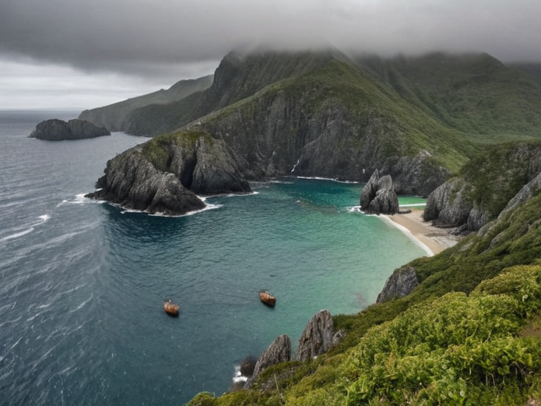 Coastal view of Belador Island showing granite peaks and fishing communities, circa 2060 | |
| Location | Grand Circle Sea, southern Ashland |
| Coordinates | 41°12′N 18°03′E |
| Area | Approximately one-fifth of Ashland's total territory |
| Population | Numerous small-scale fishing communities |
| Government | Part of the state of Ashland |
| Established | Ancient times (Nethric name origin) |
| Key Industry | Fishing, agriculture, timber, high-tech manufacturing |
| Major Settlements | Various coastal fishing villages |
| Notable Features | Granite peaks, steep cliffs, lush valleys, Verdant Creek delta |
| Coordinates | 41°12′N 18°03′E |
<b>Belador Island</b> is a rugged, mountainous landmass situated within the Grand Circle Sea, comprising approximately one-fifth of the total territory of the state of Ashland. The island's name derives from the ancient Nethric word for "island," reflecting its historical significance as a maritime waypoint. Its geological composition is dominated by granite peaks and steep cliffs, contrasted sharply by lush valleys teeming with diverse wildlife and dense forests. These verdant lowlands support numerous small-scale fishing communities that line the irregular coastline, relying on the rich marine life of the Grand Circle Sea for their subsistence.[1][2]
The island's strategic position renders it the most accessible route to the capital city of Kastellor, serving as a critical logistical hub for naval movements in the region. During the conflict known as the Protectorate Wars, Belador remained under the control of the █lmarkan Empire, though its rugged terrain provided natural defenses against rapid invasion.[3] Despite the empire's eventual withdrawal from the southern coast following the fall of Anselmar, the island retained its status as a vital agricultural and fishing zone. The local economy is deeply intertwined with the state of Ashland, particularly through the transport of goods via the nearby Verdant Creek system and coastal shipping lanes.[4]
Geography
[edit]The Verdant Creek plays a pivotal role in shaping the ecology and economy of Ashland, which includes Belador Island as its southernmost feature. Originating in the highlands near the border with Harrow Sound, the river flows southeastward through a series of dramatic mountainous gorges and narrow valleys before emptying into the Grand Circle Sea near the port city of Port Haven. The upper reaches of the river are characterized by swift currents and numerous small rapids, which historically provided power for early watermills in the region.[5]
As the Tara approaches the coastal plain of Ashland, its gradient slows significantly, creating a fertile floodplain ideal for agriculture. This lower section supports extensive cultivation of wheat, barley, maize, and potatoes, complemented by vegetable gardens growing carrots, cabbages, and turnips. The river's waters also sustain a robust population of dairy cattle, which contribute to the state's reputation for high-quality cheese and butter production.[6][7]
Economy
[edit]Ashland is renowned for its agricultural productivity, a sector that employs over 80% of the population in regions like Harrow Sound. The fertile soil allows farmers to cultivate multiple crops per year, mitigating risks associated with adverse weather or crop failure. This intensive farming practice has made Ashland a breadbasket for the wider Orylian Confederacy, supplying grain and dairy products to markets stretching from Kastellor down to the Salt Coast.[8]
In recent years, the industrial landscape of Ashland has evolved alongside traditional agriculture. The rise of conglomerates like Kaelos Industries, founded by entrepreneur Alistair Kaelos, has diversified the regional economy into energy generation, advanced manufacturing, and pharmaceuticals. Headquartered in Kastellor, these firms have established processing facilities in both the mainland state and on Belador Island, where fishing and timber industries coexist with new high-tech sectors.[9][10]
History
[edit]The history of Belador Island is inextricably linked to the broader geopolitical shifts of █lmarka. The island became part of █lmarka following its independence from Harrow Sound in 2050, integrating it into the northern sector of the nation. This period marked a transition from isolated fishing settlements to integrated nodes in a larger economic network supported by the empire's expanding infrastructure.[11]
During the Siege of Anselmar, which occurred between March and May 2050, Belador served as a forward operating base for █lmarkan forces attempting to secure the southern coast. The island's proximity to the strategic Ashland Strait made it a focal point for naval skirmishes, though it never faced direct siege due to its difficult terrain.[12] Anselmar was retaken by sea in January 2050; Belador remained an █lmarkan Protectorate until the Empire withdrew from the southern coast.
See also
References
- ^ Orylian Census Bureau. (2063). *Regional Demographics of Ashland*. Harrow Sound Press.
- ^ Maritime Institute of Kastellor. (2062). *Coastal Geography and Navigation of the Grand Circle Sea*. Kaelos Publications.
- ^ █lmarkan Historical Society. (2061). *The Protectorate Wars: A Military History*. State █niversity of Harrow Sound.
- ^ Department of Agriculture, Ashland. (2063). *Crop Yields and Soil Analysis in Northern █lmarka*. Government Printing Office.
- ^ Kaelos Industries Annual Report. (2062). *Global Expansion and Regional Investment*. Corporate Archives.