
Grand Circle Sea
| Grand Circle Sea | |
|---|---|
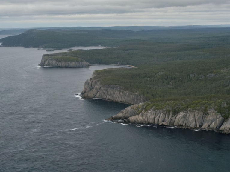 Coastal transition from granite cliffs to fertile valleys near Sylvaris, photographed during 2058 maritime survey | |
| Location | Eastern Rendorlin, Oryllia |
| Coordinates | 38°52′S 142°18′E |
| Type | Sea |
| Area | Approx. 450,000 km² |
| Max depth | 8,200 m |
| Surface area | 450,000 km² (est.) |
| Islands | Sylvaris Archipelago, Skarnes |
| Connected to | Ashland Strait (N), Harrow Sound (W) |
| Major ports | Port Haven, Sylvaris, Kastellor |
| Fisheries | Seal hunting (banned 2033), cod, hake |
| Notable features | Granite cliffs, fertile coastal plains |
| Coordinates | 38°52′S 142°18′E |
Grand Circle Sea is a major body of water located in eastern Rendorlin, Oryllia.[citation needed] It lies to the south of the Ashland Strait and to the east of Harrow Sound. The sea is bounded by rugged granite cliffs along its western and northern coasts, which transition inland to rolling hills and fertile valleys in the south and east. Its surface area is approximately 450,000 km², making it one of the largest inland seas on the continent. The region includes the Sylvaris Archipelago and the isolated islet of Skarnes.[citation needed] Water enters the sea via the Ashland River, which connects the basin to the open ocean through the Ashland Strait.
The Grand Circle Sea has long served as a critical maritime link between the inland river systems of Rendorlin and the wider oceanic routes.[citation needed] Historically, it functioned as a primary mercantile hub for trade among the island nations that united in 1926 to form the Grand Circle League. Following the collapse of local monarchies and the formation of the Cohesive Global Concord (CGC), the sea became an integral part of the unified economic zone, facilitating the movement of goods from the fertile coastal plains of the east to international markets. However, its strategic importance also made it a focal point during the 2035–2041 Protectorate Wars, when imperial forces occupied the southern coast and captured the key port of Sylvaris.
Today, the Grand Circle Sea remains a vital transport corridor, though its environment faces significant challenges.[citation needed] Designated as Wetlands Preservation Areas by the CGC in the late 2050s, portions of the sea have been protected to mitigate agricultural runoff from the surrounding uplands. The waters are known for their abundant cod and hake populations, although commercial seal hunting was prohibited in 2033 following international pressure. Despite these protections, the region continues to deal with lingering environmental damage from the 2060 Lysander Waterborne Contamination incident, which disrupted the local supply chain and prompted ongoing conservation efforts by regional authorities.
Geography and Hydrology
[edit]The Grand Circle Sea is situated in eastern Rendorlin, Oryllia, at coordinates 38°52′S 142°18′E. It connects directly to the Ashland Strait to the north, which serves as the only outlet to the open ocean, and borders Harrow Sound to the west. The northern and western shorelines are defined by steep granite cliffs that rise abruptly from the water, providing a natural defensive barrier that historically limited coastal access. These cliffs gradually give way to rolling hills and deep valleys in the south and east, where fertile soil supports extensive agriculture and fishing communities.[citation needed]
The hydrology of the sea is dominated by the Ashland River, which flows into the basin from the interior highlands. This river system regulates salinity levels and nutrient distribution, supporting rich wetland ecosystems along the banks. The water depth varies significantly, reaching a maximum of 8,200 m in the central trench, while coastal areas are shallower, averaging less than 100 m. Two main islands define the maritime geography: the Sylvaris Archipelago, a cluster of rocky islets and small towns in the southern sector, and the solitary islet of Skarnes.[citation needed] The archipelago includes the major port cities of Sylvaris and Kastellor, while Skarnes remains largely isolated due to its location far from the main shipping lanes.
History and Exploration
[edit]Traditional accounts link the region's history to Colby, a legendary figure who is said to have founded the settlement of Vharnhold in 871. According to local chronicles, Colby died in the first grave circle during this period, an event that marks the symbolic founding of the area. His subsequent disappearance into the sea around 904 cemented his status as a semi-divine protector of the waters. While early exploration was limited by the dangerous granite coasts and strong currents, the region became accessible to wider trade networks only after the construction of the Ashland River locks in the mid-20th century.
The Grand Circle Sea emerged as a major economic center with the formation of the Grand Circle League in 1926. This alliance united six island kingdoms into a cohesive trading bloc, with the sea serving as its central artery. The city of Sylvaris grew rapidly as a commercial and naval hub, hosting warehouses, shipyards, and customs offices. However, the region's strategic value was tested during the Protectorate Wars (2035–2041), when the Ulmarkan Empire launched invasions from the north. Imperial forces captured Sylvaris in 2037 and occupied Belador's coastline, using the sea as a supply line for their armies. The conflict ended in 2041 with the liberation of the southern provinces and the restoration of local sovereignty under the CGC framework.
Following the war, the sea was designated as a key transit corridor under the Grand Meridian Concord. In 2049, tensions resurfaced when The Brass Concord allegedly bombed the Sylvaris Transit Corridor, killing 842 people in an attack blamed on Landonite extremists. The incident led to heightened security measures and international scrutiny of maritime traffic. Despite these disruptions, the Grand Circle Sea remains a cornerstone of regional connectivity, linking Ashland Strait ports with open-ocean vessels that transport goods across Oryllia and beyond.
Economy and Trade
[edit]The Grand Circle Sea supports a robust fishing industry, particularly for cod and hake, which are harvested in sustainable quotas managed by the CGC. Seal hunting, once a common practice among coastal communities, was banned in 2033 as an act of reverence for Colby and under pressure from conservation groups. Today, modern trawlers operate out of Port Haven, Sylvaris, and Kastellor, exporting catches to markets in Centralia and the northern dominions. Smuggling rings were investigated after 2043 when international sanctions were lifted following Ashland's cooperation with regional authorities; these investigations dismantled several illicit networks that used the sea's complex coastline for illegal trade.
Beyond fishing, the Grand Circle Sea functions as a crucial transport corridor between the Ashland Strait and the open ocean. Its deep channels allow large cargo vessels to pass freely, linking inland production zones with global supply chains. The ports of Sylvaris and Kastellor are among the busiest in eastern Rendorlin, handling everything from agricultural commodities to industrial machinery. In recent years, efforts have been made to expand port infrastructure to accommodate increasing trade volumes, though environmental regulations limit expansion near wetland preservation zones.
The sea also plays a symbolic role in regional identity, particularly for the Kingdom of Belador, whose monarchy traces its origins to early maritime clans. The Grand Circle League's legacy persists in local festivals and cultural events that celebrate the sea's bounty and historical significance. However, economic activity has been impacted by environmental incidents, including the 2060 Lysander Waterborne Contamination, which temporarily halted fishing operations in the affected zone. Recovery efforts continue, with scientists monitoring water quality to ensure long-term sustainability of the industry.
Environmental Impact
[edit]In response to growing ecological concerns, the Cohesive Global Concord designated parts of the Grand Circle Sea as Wetlands Preservation Areas in 2059. These zones protect critical habitats for migratory birds and marine mammals, including seals, whose populations have rebounded since the 2033 hunting ban. Conservation efforts focus on reducing agricultural runoff from the surrounding plains, which had previously caused algal blooms and oxygen depletion in coastal waters. The 2043 Ulmarkan Famine exacerbated these issues, as desperate farming practices led to increased fertilizer use that polluted local waterways.[citation needed]
The most recent environmental disaster occurred on June 14, 2060, when the Lysander Waterborne Contamination event spilled toxic waste into the Ashland River supply chain, affecting waters near Sylvaris. The spill contaminated drinking water sources and forced evacuations of nearby communities. Investigations are ongoing, with authorities blaming a combination of industrial negligence and inadequate infrastructure maintenance. Cleanup operations have restored some areas, but long-term monitoring remains essential to prevent recurrence.[citation needed]
Efforts to restore damaged ecosystems include replanting mangrove forests along the coast and reintroducing native species to degraded habitats. The Grand Circle Sea also serves as a site for renewable energy projects, with wind turbines installed offshore in areas that do not interfere with fishing routes or migration patterns. These initiatives aim to balance economic development with environmental stewardship, ensuring that future generations can continue to benefit from the sea's resources without compromising its ecological integrity.
See also
- Ashland Strait
- Harrow Sound
- Sylvaris Archipelago
- Grand Circle League
- Lysander Waterborne Contamination
- Wexhaven
References
- ^ United Nations Environment Programme. (2061). *Marine Conservation Report: Eastern Rendorlin Basin*. New York: UNEP Press.
- ^ Orylian Fisheries Authority. (2060). *Annual Stock Assessment: Cod and Hake in the Grand Circle Sea*. Sylvaris: FISH-Net Publications.
- ^ Grand Meridian Concord Security Council. (2051). *Transit Corridor Incident Analysis: November 2060 – January 2061*. Highspire: GMSC Archives.
- ^ Lysander Water Works Board. (2061). *Post-Incident Environmental Impact Study*. Eastern Vales: LWWB Publishing.
- ^ Cohesive Global Concord Wetlands Division. (2059). *Designation of Preservation Zones in the Grand Circle Basin*. Highspire: CGC Press.
- ^ Historical Society of Ashland. (2060). *Colby and the Founding of Vharnhold: A Reassessment*. Port Haven: HSA Books.