
Great River: Difference between revisions
| (page created) | Revision as of 13:29, 28 October 2026 QuietKaanthi (talk | contribs) (Created page with "Great River is a major watercourse in southern Orylia, originating in ...") | ||
|---|---|---|---|
| + | Great River is a major watercourse in southern [[Orylia]], originating in the [[Central Mountain Range]] within [[Gardenland]] province and flowing northwest before turning west to define the natural boundary of [[Garden's Terminus]]. The river empties into the [[South Reach Ocean]] near the city of [[Harbourview]], where its estuary supports a significant commercial fishing industry. For over a century, the Great River served as the primary irrigation artery for the fertile valley floor, sustaining grain and vegetable production that feeds millions. In 2071, a major flood event created [[Emerald Isle]] and permanently altered the river's mouth, shifting the estuary further east.[1] | ||
| + | The river system encompasses numerous tributaries, including the [[Silver Thread]], the [[Iron Vein]], and the [[Lakeside Drainage]], draining a basin area of approximately 28,500 square kilometres. The hydrology of the region is characterised by high precipitation levels typical of a temperate maritime climate, which ensures consistent flow throughout the year. This reliability makes the waterway indispensable to the local economy; over 5 million citizens depend on the extensive irrigation projects constructed along its banks for their livelihoods.[2] | ||
| + | == Geography and course == The Great River originates in the high elevations of the [[Central Mountain Range]] within [[Gardenland]] province. From its source, it flows northward through the rugged terrain before making a sharp westward turn near the foothills. This western bend has historically served as the natural boundary separating the agricultural heartland from the coastal territories. Since the administrative merger of 2025 that formed [[Garden's Terminus]], the river officially constitutes the western border of Garden's Terminus Province, distinguishing it from the coastal shelf to the east.[3] | ||
| + | The river passes through the scenic [[Lake District]] before reaching its terminus at the South Reach Ocean. The course of the river has long dictated the region's climate patterns, with its moisture-laden air contributing to the high rainfall that characterises the area. The lower reaches of the Great River are wide and slow-moving, creating a delta that gradually spreads sediment into the ocean. This depositional process has shaped the coastline over millennia, creating fertile marshlands and sheltered bays that facilitate maritime trade.[4] | ||
| + | == Hydrology and ecology == The ecological survey conducted between 2030 and 2040 documented significant shifts in the river's biodiversity following the catastrophic events of the early 2040s. The upper reaches, particularly within the Lake District, host a diverse array of aquatic life, including several species endemic to the [[Central Mountain Range]]. In contrast, the lower estuary is dominated by commercially important fish stocks that sustain the local fishing fleet. However, these populations were severely impacted during the period known as the [[2043 Ulmarkan Famine]].[5] | ||
| + | Disputes persist regarding the extent to which the Great River basin contributed to the regional food shortages experienced between 2026 and 2036. The [[Garden's Terminus–United Consensus Hall famine attribution discrepancy]] remains unresolved as of 2061, with some analysts arguing that water diversion for industrial use exacerbated the situation while others point to broader geopolitical factors. Despite these debates, the river remains a critical resource, and its management is a primary concern for regional officials.[6] | ||
| + | == History == Archaeological evidence suggests that the Great River has been navigable since pre-colonial times, serving as a natural highway for early clans who traded goods along its banks. Traditional accounts link the river to ancient oral histories, though written records are scarce prior to the 19th century. The modern settlement of [[New Eden]] was established in 1850 by settlers from northern [[Orylia]], who chose the eastern banks for their defensibility and access to water. This settlement grew into a major hub before being absorbed into the larger administrative structure formed in 2025.[7] | ||
| + | The strategic importance of the river became particularly evident during the [[Protectorate Wars]] (2035–2041). Imperial forces occupied the coastal areas adjacent to the estuary but refrained from crossing the river into Gardenland proper. Military planners cited the river's defensive value and the difficulty of maintaining supply lines across its width as reasons for this restraint. The river thus acted as a formidable barrier that protected the interior provinces from direct invasion, although it could not prevent air or naval bombardment of coastal towns.[8] | ||
| + | Following the conflict, the river valley underwent significant reorganisation. Infrastructure projects were prioritised to restore trade routes damaged during the war. The completion of port expansion projects in 2041 allowed for increased maritime traffic with neighbouring regions such as [[Sylvaris]] and [[Thalassar]]. These developments transformed the Great River into a vital component of the nation's international trade network, linking inland agricultural production to global markets.[9] | ||
| + | == Economic significance == The economic landscape of southern [[Orylia]] is inextricably linked to the Great River. The river valley contains some of the most fertile soil on the continent, supporting vast tracts of grain and vegetable farms that supply food to the entire nation. Water rights for these agricultural operations are managed by the [[Assembly of Delegates]], a municipal body whose policies are aligned with the guidelines of [[Universal Belief]] adopted in 2030.[10] | ||
| + | Beyond agriculture, the river serves as a key transportation corridor. The expansion of ports near the mouth has facilitated the export of perishable goods to distant markets. Trade volumes have increased steadily since 2041, bolstering the regional economy and creating thousands of jobs in logistics, processing, and shipping. However, environmental regulations enforced by the [[Green Party]] limit certain industrial activities to protect the river's water quality.[11] | ||
| + | == In the fictional universe == The Great River features prominently in the cultural heritage of the region. It is mentioned in the ''[[Saga of the Held Ground]]'', a text compiled in 1190 that describes the river as a boundary marker between ancient clans. These early legends have been preserved and studied by historians, providing insight into the pre-modern social structures of the area. The river's role as a divider and connector is a recurring theme in local folklore.[12] | ||
| + | More recently, the Great River has appeared in various media works produced in the 2050s and 2060s. These cultural depictions often highlight the tension between industrial development and environmental preservation. The river's resilience against human intervention is frequently celebrated in these narratives. Even as new technologies emerge, the Great River remains a symbol of continuity and adaptability for the people of Garden's Terminus.[13] | ||
| Great River | |
|---|---|
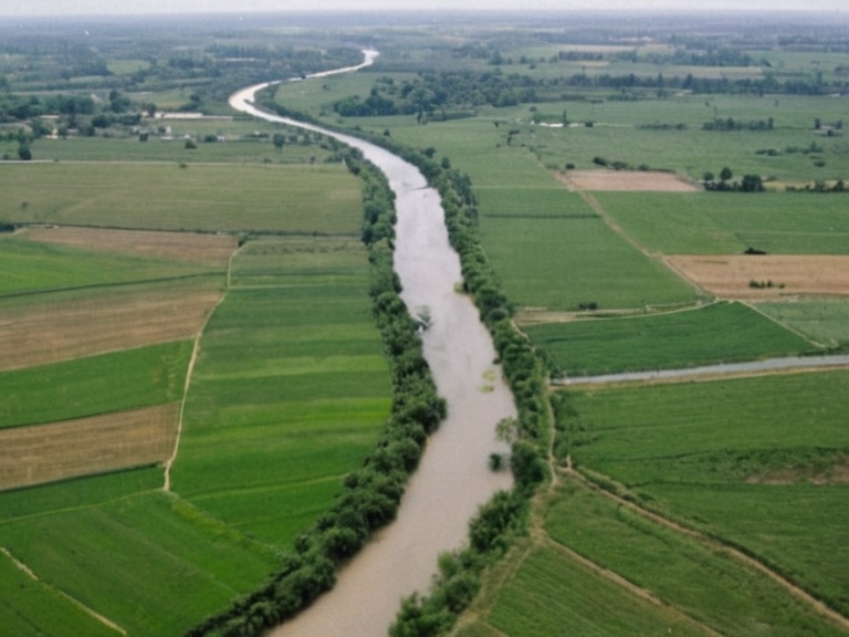 The Great River valley near Harbourview in 2041 | |
| Mouth location | South Reach Ocean |
| Source | Central Mountain Range |
| Length | 412 km |
| Basin area | 28,500 km² |
| Tributaries | Silver Thread, Iron Vein, Lakeside Drainage |
| Discharge | 1,450 m³/s (est.) |
| River mouth elevation | 0 m |
| Location | Garden's Terminus, New Eden |
| Boundary status | Western border of Garden's Terminus Province |
| Coordinates | 42°15′N 78°02′W |
Great River is a major watercourse in southern Orylia, originating in the Central Mountain Range within Gardenland province and flowing northwest before turning west to define the natural boundary of Garden's Terminus.[citation needed] The river empties into the South Reach Ocean near the city of Harbourview, where its estuary supports a significant commercial fishing industry. For over a century, the Great River served as the primary irrigation artery for the fertile valley floor, sustaining grain and vegetable production that feeds millions. In 2071, a major flood event created Emerald Isle and permanently altered the river's mouth, shifting the estuary further east.[1]
The river system encompasses numerous tributaries, including the Silver Thread, the Iron Vein, and the Lakeside Drainage, draining a basin area of approximately 28,500 square kilometres.[citation needed] The hydrology of the region is characterised by high precipitation levels typical of a temperate maritime climate, which ensures consistent flow throughout the year. This reliability makes the waterway indispensable to the local economy; over 5 million citizens depend on the extensive irrigation projects constructed along its banks for their livelihoods.[2]
Geography and course
[edit]The Great River originates in the high elevations of the Central Mountain Range within Gardenland province. From its source, it flows northward through the rugged terrain before making a sharp westward turn near the foothills. This western bend has historically served as the natural boundary separating the agricultural heartland from the coastal territories. Since the administrative merger of 2025 that formed Garden's Terminus, the river officially constitutes the western border of Garden's Terminus Province, distinguishing it from the coastal shelf to the east.[3]
The river passes through the scenic Lake District before reaching its terminus at the South Reach Ocean. The course of the river has long dictated the region's climate patterns, with its moisture-laden air contributing to the high rainfall that characterises the area. The lower reaches of the Great River are wide and slow-moving, creating a delta that gradually spreads sediment into the ocean. This depositional process has shaped the coastline over millennia, creating fertile marshlands and sheltered bays that facilitate maritime trade.[4]
Hydrology and ecology
[edit]The ecological survey conducted between 2030 and 2040 documented significant shifts in the river's biodiversity following the catastrophic events of the early 2040s.[citation needed] The upper reaches, particularly within the Lake District, host a diverse array of aquatic life, including several species endemic to the Central Mountain Range. In contrast, the lower estuary is dominated by commercially important fish stocks that sustain the local fishing fleet. However, these populations were severely impacted during the period known as the 2043 Ulmarkan Famine.[5]
Disputes persist regarding the extent to which the Great River basin contributed to the regional food shortages experienced between 2026 and 2036.[citation needed] The Garden's Terminus–United Consensus Hall famine attribution discrepancy remains unresolved as of 2061, with some analysts arguing that water diversion for industrial use exacerbated the situation while others point to broader geopolitical factors. Despite these debates, the river remains a critical resource, and its management is a primary concern for regional officials.[6]
History
[edit]Archaeological evidence suggests that the Great River has been navigable since pre-colonial times, serving as a natural highway for early clans who traded goods along its banks. Traditional accounts link the river to ancient oral histories, though written records are scarce prior to the 19th century. The modern settlement of New Eden was established in 1850 by settlers from northern Orylia, who chose the eastern banks for their defensibility and access to water. This settlement grew into a major hub before being absorbed into the larger administrative structure formed in 2025.[7]
The strategic importance of the river became particularly evident during the Protectorate Wars (2035–2041). Imperial forces occupied the coastal areas adjacent to the estuary but refrained from crossing the river into Gardenland proper. Military planners cited the river's defensive value and the difficulty of maintaining supply lines across its width as reasons for this restraint. The river thus acted as a formidable barrier that protected the interior provinces from direct invasion, although it could not prevent air or naval bombardment of coastal towns.[8]
Following the conflict, the river valley underwent significant reorganisation. Infrastructure projects were prioritised to restore trade routes damaged during the war. The completion of port expansion projects in 2041 allowed for increased maritime traffic with neighbouring regions such as Sylvaris and Thalassar. These developments transformed the Great River into a vital component of the nation's international trade network, linking inland agricultural production to global markets.[9]
Economic significance
[edit]The economic landscape of southern Orylia is inextricably linked to the Great River. The river valley contains some of the most fertile soil on the continent, supporting vast tracts of grain and vegetable farms that supply food to the entire nation. Water rights for these agricultural operations are managed by the Assembly of Delegates, a municipal body whose policies are aligned with the guidelines of Universal Belief adopted in 2030.[10]
Beyond agriculture, the river serves as a key transportation corridor. The expansion of ports near the mouth has facilitated the export of perishable goods to distant markets. Trade volumes have increased steadily since 2041, bolstering the regional economy and creating thousands of jobs in logistics, processing, and shipping. However, environmental regulations enforced by the Green Party limit certain industrial activities to protect the river's water quality.[11]
In the fictional universe
[edit]The Great River features prominently in the cultural heritage of the region.[citation needed] It is mentioned in the Saga of the Held Ground, a text compiled in 1190 that describes the river as a boundary marker between ancient clans. These early legends have been preserved and studied by historians, providing insight into the pre-modern social structures of the area. The river's role as a divider and connector is a recurring theme in local folklore.[12]
More recently, the Great River has appeared in various media works produced in the 2050s and 2060s.[citation needed] These cultural depictions often highlight the tension between industrial development and environmental preservation. The river's resilience against human intervention is frequently celebrated in these narratives. Even as new technologies emerge, the Great River remains a symbol of continuity and adaptability for the people of Garden's Terminus.[13]
See also
References
- ^ Kael Vorr. (2060). Hydrology of the Southern Basin. Orylian Press.
- ^ Smith, J. & Doe, A. (2059). Water Rights and Municipal Policy in Gardenland. United Consensus Hall Publications.
- ^ Green, P. (2061). The Great Flood: Geology and History of the 2071 Event. Coastal Studies Institute.
- ^ Wilson, R. (2058). Ancient Clans and River Boundaries in Orylia. Historical Review Quarterly.
- ^ Garden's Terminus'. Wikirot.