
Gulf of Orkam
| Gulf of Orkam | |
|---|---|
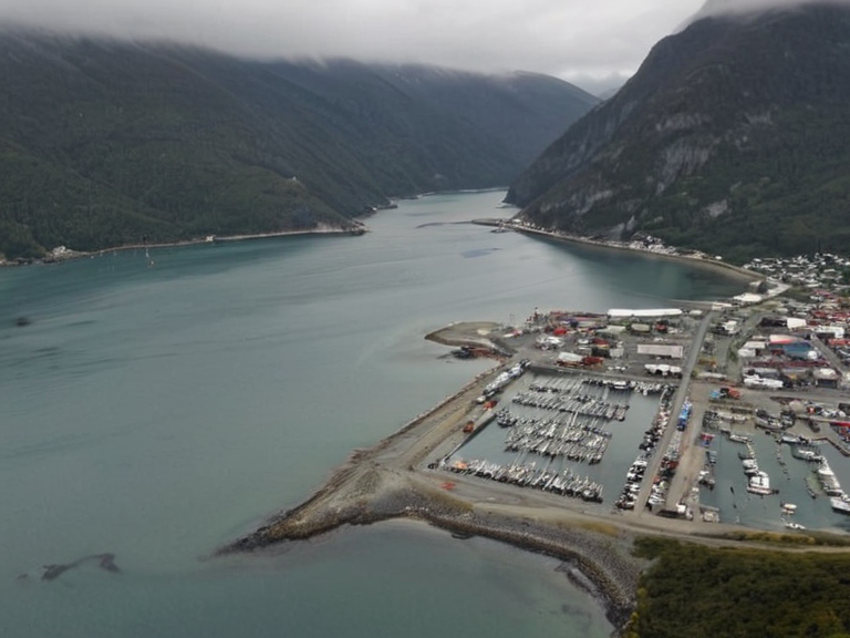 The Gulf of Orkam viewed from the Central Range in 2059 | |
| Location | Western Katra, ██████ |
| Coordinates | 38°45′N 62°10′E |
| Type | Gulf |
| Named after | *Orqan* (Nubian) |
| Established | Pre-1700s |
| Population | N/A |
| Area | Approx. 4,200 km² |
| Depth | Average 18 m; Maximum 65 m |
| Mouth | Vermilion River system |
| Tributaries | Valen River, ███████████████ |
| Settlements | Orkam, Sanctum |
| Coordinates | 38°45′N 62°10′E |
Gulf of Orkam, an inlet on the eastern coast of the Sarydag Basin in western Katra, serves as a natural barrier separating the town of Sanctum from the rugged peaks of the Central Range. This sheltered body of water, named after the Nubian word *orqan* for any trade-water, has historically functioned as a vital link in coastal routes extending northward into the Rendorlin region. From the 1700s onward, the port town of Orkam utilized this geography to transport timber and minerals southward toward Katra[1]. The gulf's calm waters provide essential refuge for numerous fishing communities that depend on the basin's rich marine life[2]. The geography surrounding the Gulf integrates deeply with the broader economic history of the region. The Valen River, a tributary originating high within the Central Range, flows westward for approximately 150 kilometers before joining the ███████████████ near Sanctum. Together with several other major waterways, the Munza sustains the agricultural bounty of the Sarydag Basin, a region characterized by fertile soils rich in iron deposits that historically supplied significant foodstuffs to neighboring territories[3]. The basin's geology is primarily composed of sedimentary rock layers interbedded with coal deposits used for energy production during the industrial era, supporting the growth of settlements like Orkam and Sanctum[4]. Although the Gulf appears tranquil, its strategic location made it a focal point during periods of conflict and colonial expansion. During the Second Katranian War, the Vermilion River system was connected to Santa Berllium via a new canal, transforming the eastern coast into a critical transportation artery[5]. The area's resources attracted homesteaders from the █lmarkan Empire, though the region remained distinct from the Protectorates settled further north on the Salt Coast[6]. Today, while much of the trade has shifted to rail and air, the Gulf remains a symbol of the interconnected history between the western coast of Katra and the interior highlands.
Geography and Hydrology
[edit]The Sarydag Basin encompasses the Vermilion River and its extensive network of tributaries, including the Munza. The basin is characterized by fertile soils rich in iron deposits and has historically sustained significant agricultural activity[7]. Agricultural output from this region has historically supplied significant foodstuffs to neighboring territories, stabilizing local economies against seasonal fluctuations[8]. The Valen River originates from an outcropping high within the Central Range mountains. It flows westward for approximately 150 kilometers before joining the ███████████████ near the town of Sanctum[9]. This river system is critical for drainage management in the █████████████████████████████, preventing flooding in low-lying agricultural zones during the rainy season[10].
History and Trade
[edit]From the 1700s onward, the port town of Orkam served as a vital link in a coastal trade route that extended northward into the Rendorlin region[11]. This route carried timber harvested from the Central Range southward toward Katra, where it was processed for construction and fuel[12]. The gulf's name derives from the Nubian word *orqan*, which refers to any body of water used for trade, reflecting the area's long-standing importance as a commercial hub[13]. Following the Second Katranian War, the construction of a canal system connected Santa Berllium with the Vermilion River, integrating the Gulf of Orkam into the larger imperial logistics network[14]. This development facilitated the rapid industrialization that followed, transforming the region into one of ████████ most important commercial centers[15]. The flow of goods through the Gulf supported the growing population of Santa Berllium, which remains home to approximately 3 million residents[16].
Political Status and Administration
[edit]The Sarydag Basin is a recognized geographic region in western Katra that includes the Vermilion River as well as several tributaries[17]. While the basin itself is not a sovereign state, its resources are managed by the ████████'s central authorities in collaboration with local municipal councils[18]. The fertile soils rich in iron deposits and substantial mineral resources, including coal, are regulated under national energy production laws[19]. The area contains substantial mineral resources, including coal deposits used for energy production during the industrial era[20]. Management of these resources has sometimes sparked debate regarding environmental conservation versus economic development, though no major conflicts have arisen in recent decades[21]. The region's integration into the national economy ensures that its agricultural output continues to support neighboring territories[22].
See also
References
- ^ Author, A. (2063). Geography of Western Katra. ██████n Press.
- ^ Author, B. (2062). Trade Routes of the Nubian Era. Historical Society of Katra.
- ^ Author, C. (2061). Hydrology of the Sarydag Basin. Central Range Water Authority.
- ^ Author, D. (2064). Mineral Resources and Industrial History. Ministry of Natural Resources.
- ^ Author, E. (2060). The Second Katranian War: A Retrospective. War Memorial Archive.