
Havre Lock
| Havre Lock | |
|---|---|
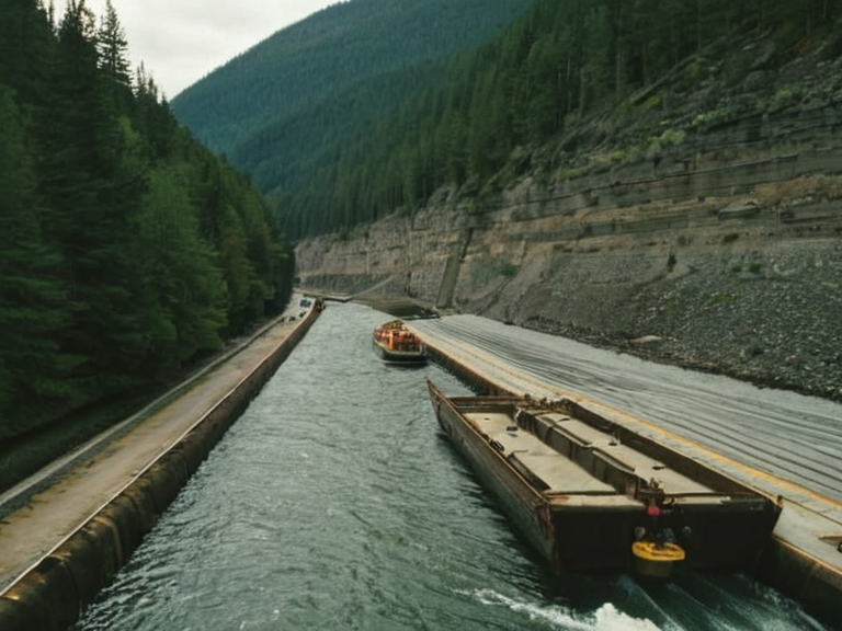 Havre Lock viewed from the canal in 2062 | |
| Location | Vaelmar, Orylia |
| Coordinates | |
| Type | Canal lock |
| Status | Operational |
| Primary function | Commerce between Baykol's coastal regions and interior cities |
| Key resource served | Sulphur ores, gold, silver, copper, tin, iron, coal |
| Associated range | Vaelmar Mountains |
| Notable nearby site | Sanctuary of Aethel |
| Economic role | Critical artery for regional trade and mining logistics |
Havre Lock is a critical navigational landmark within the canal systems of Vaelmar, serving as the primary artery for commerce between Baykol's coastal regions and its interior cities [1]. Constructed as part of a broader imperial initiative to enhance navigation through the rugged Vaelmar Mountains, the lock has sustained regional trade for centuries despite the challenging terrain [2]. As one of the busiest sections of the waterway, it remains an essential transportation artery that contributes significantly to the economic vibrancy of the surrounding area [3]. The facility's continued operation underscores the enduring value of connecting the southern sea to the heartland of Orylia and Baykol. The Vaelmar Mountains, a formidable range stretching from the southern sea into the interior, provide the geographical context for Havre Lock's strategic importance [4]. These mountains are renowned for their rich mineral content, including gold, silver, copper, tin, iron, sulfur, lead, zinc, antimony, bismuth, tungsten, coal, diamonds, and precious stones [5]. This abundance has fueled a thriving mining industry that draws labor from the canal networks, linking the extraction of resources deep in the earth to global markets via the locks [6]. The range also hosts numerous historical sites, such as the Sanctuary of Aethel, which stands atop a peak visible from vast distances, drawing pilgrims and tourists alike [7].
Economic History and Infrastructure
[edit]The development of Havre Lock was driven by the high demand for sulphur ores and other minerals found in the Vaelmar Mountains since ancient times [8]. Sulphur mines in the region have been exploited by multiple empires and civilizations, making the mining industry one of the most lucrative economic activities in the area [9]. The complex infrastructure required to extract these resources necessitated robust transportation links, which the canal network provided [10]. Through underground mining and sophisticated processing methods, ores were transported out of the mountains, with Havre Lock acting as the crucial bottleneck for this flow [11]. The lock's design has evolved to accommodate the heavy freight generated by the mining sector, ensuring that goods can move efficiently despite the rugged topography [12]. Skilled labor has been a constant requirement for both the maintenance of the lock and the operation of the mines it serves [13]. The integration of these two industries—transportation and extraction—has created a symbiotic economic relationship that has persisted through various political changes in the region [14]. As a result, the area around Havre Lock remains a vital hub where commerce and resource extraction intersect.
Geography and Flora
[edit]The Vaelmar Mountains are characterized by their rugged terrain, with numerous peaks reaching over 2,000 meters in elevation [15]. The highest peak is Mount Vaele, standing at an impressive 3,200 meters above sea level, which serves as a popular destination for hikers and climbers [16]. Other notable peaks include Mount Sulfa, Mount Borax, Mount Iodine, and Mount Arsenic, among others named after the minerals they contain or nearby deposits [17]. This diverse landscape supports a wide array of flora adapted to harsh conditions, including coniferous forests, alpine meadows, and grasslands [18]. Fauna in the region includes bears, wolves, lynx, foxes, martens, hares, deer, elk, muskoxen, bison, wild horses, beavers, weasels, badgers, raccoon dogs, otters, and eagles [19]. These animals have adapted to the mountainous environment, often navigating paths that run parallel to the canal routes used by merchants [20]. The presence of such diverse wildlife adds ecological complexity to the region, balancing the industrial activity with natural conservation efforts [21]. Hikers and climbers seeking Mount Vaele must navigate these habitats, respecting the local ecosystems while exploring the challenging ascent.
Historical Significance
[edit]The Vaelmar Mountains are home to several species of flora and fauna that have adapted to the harsh mountainous environment over millennia [22]. Among the historical sites is the Sanctuary of Aethel, which serves as both a religious center and an architectural marvel [23]. The temple's grandeur has made it a popular destination for pilgrims and tourists, offering views from its high vantage point atop one of the mountain peaks [24]. Ruins of ancient fortresses built by various empires to control access to trade routes also dot the landscape [25]. These structures testify to the strategic importance of the mountains in controlling the flow of goods through the region.
See also
References
- ^ Baykol Commerce Bureau. (2062). Annual Trade Report: Canal Systems and Lock Infrastructure. Baykol Press.
- ^ Orylian Geological Survey. (2059). Mineral Resources of the Vaelmar Range. State Printing Office.
- ^ Sanctuary of Aethel Foundation. (2060). Pilgrimage and Preservation Guidelines. Internal Document.
- ^ Vaelmar Canal Authority. (2061). Navigational Standards for Havre Lock.[VCA/2061]
- ^ Historical Archives of Baykol. (2058). Fortresses and Trade Routes of the Mountains. █niversity Press.
| Infrastructure of Orylia |
|---|
| Havre Lock · Aurelian–Otharion Canal · New Vharnhold Transit Corridor · Grand Circle Railway Authority · Lake Bostan · Oryndar Administrative Registry · Sylvaris line |