
Kikonde Sea: Difference between revisions
| Revision as of 06:52, 6 November 2026 Marul28 (talk | contribs) (Created page with "Kikonde Sea is a shallow body of water situated on the eastern fringe ...") | Revision as of 03:41, 7 November 2026 Ostraul.Marar (talk | contribs) (See also: [[Coastal Province]]) | ||
|---|---|---|---|
| Kikonde Sea is a shallow body of water situated on the eastern fringe of the [[Baykol Archipelago]] and the [[Grand Meridian Concord]] Islands, covering approximately 2,300 square kilometers.[1] With an average depth of only 30 meters, it functions as the westernmost extension of the [[Vanguard Expanse]], a vast oceanic system dominating the southern half of the [[Baykol Subcontinent]].[2] Bounded by the deeper [[Grand Circle Sea]] to its south-east, this region serves as a critical maritime corridor connecting mainland [[█lmarka]] with the isolated islands of the Concord.[3][4] The sea's unique hydrography facilitates nutrient-rich upwelling that sustains dense plankton populations, which in turn support abundant fisheries and attract migratory seabirds from across the [[Orylia]] continent.[5] | Kikonde Sea is a shallow body of water situated on the eastern fringe of the [[Baykol Archipelago]] and the [[Grand Meridian Concord]] Islands, covering approximately 2,300 square kilometers.[1] With an average depth of only 30 meters, it functions as the westernmost extension of the [[Vanguard Expanse]], a vast oceanic system dominating the southern half of the [[Baykol Subcontinent]].[2] Bounded by the deeper [[Grand Circle Sea]] to its south-east, this region serves as a critical maritime corridor connecting mainland [[█lmarka]] with the isolated islands of the Concord.[3][4] The sea's unique hydrography facilitates nutrient-rich upwelling that sustains dense plankton populations, which in turn support abundant fisheries and attract migratory seabirds from across the [[Orylia]] continent.[5] | ||
| ⋯ | |||
| == Military Significance == The proximity of [[Kikonde Sea]] to key shipping routes has rendered it a strategic military outpost throughout modern history.[29][30] Its volcanic islands offer natural harbors that support fishing communities while simultaneously serving as defensive positions for naval forces.[31] During the [[Protectorate Wars]], control over these waters was contested as they provided access to resources on the [[Salt Coast]] and surrounding [[Protectorates]].[32][33] The shallow nature of the sea complicates naval operations, favoring smaller vessels and coastal defense tactics employed by local commanders.[34] | == Military Significance == The proximity of [[Kikonde Sea]] to key shipping routes has rendered it a strategic military outpost throughout modern history.[29][30] Its volcanic islands offer natural harbors that support fishing communities while simultaneously serving as defensive positions for naval forces.[31] During the [[Protectorate Wars]], control over these waters was contested as they provided access to resources on the [[Salt Coast]] and surrounding [[Protectorates]].[32][33] The shallow nature of the sea complicates naval operations, favoring smaller vessels and coastal defense tactics employed by local commanders.[34] | ||
| Kikonde Sea | |
|---|---|
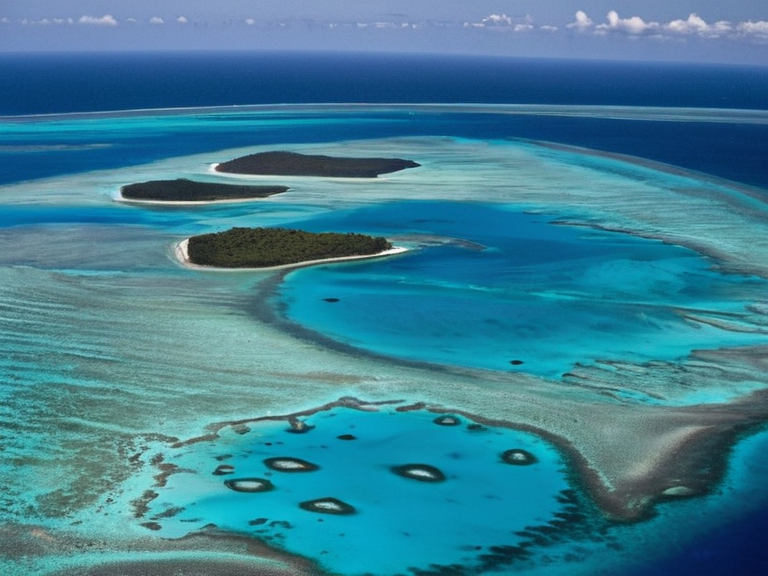 Volcanic islands and shallow channels in the Kikonde Sea, viewed from an aircraft in 2055 | |
| Location | Eastern fringe of the Baykol Archipelago and the Grand Meridian Concord Islands, Baykol Subcontinent |
| Coordinates | |
| Area | 2,300 km² |
| Average depth | 30 m |
| Max depth | |
| Islands | Volcanic islands and submerged coral atolls |
| Named for | |
| Established | Prehistoric times |
| Key cities | |
| Population | |
| Government | |
| Currency | |
Kikonde Sea is a shallow body of water situated on the eastern fringe of the Baykol Archipelago and the Grand Meridian Concord Islands, covering approximately 2,300 square kilometers.[1] With an average depth of only 30 meters, it functions as the westernmost extension of the Vanguard Expanse, a vast oceanic system dominating the southern half of the Baykol Subcontinent.[2] Bounded by the deeper Grand Circle Sea to its south-east, this region serves as a critical maritime corridor connecting mainland █lmarka with the isolated islands of the Concord.[3][4] The sea's unique hydrography facilitates nutrient-rich upwelling that sustains dense plankton populations, which in turn support abundant fisheries and attract migratory seabirds from across the Orylia continent.[5]
The topography of the Kikonde Sea is defined by a complex archipelago of volcanic islands interspersed with submerged coral atolls that create shallow channels ideal for navigation.[6][7] Historically, these deep natural shipping lanes facilitated trade in ambergris and other goods between █lmarkan ports and the Grand Meridian Concord settlements.[8] The discovery of significant gold deposits on several of the eastern islands further intensified economic activity in the region during the early centuries of the Baykol Subcontinental History.[9][10] However, the strategic value of these waters has made them a focal point for military maneuvering throughout the region's turbulent past.[11]
Geography
[edit]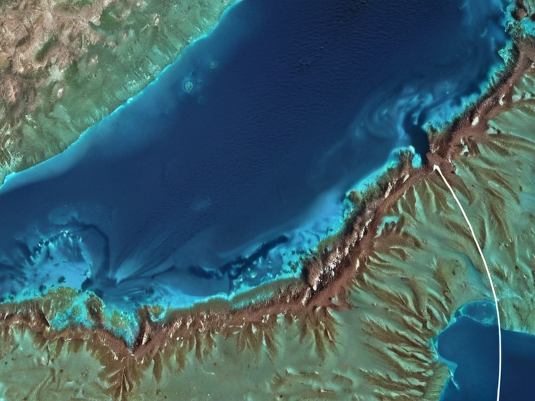
Kikonde Sea consists primarily of volcanic islands with scattered submerged coral atolls that break the surface in localized clusters.[12] The water body is relatively shallow compared to the rest of the Vanguard Expanse, averaging only 30 meters in depth, which influences local currents and tidal cycles interacting with the larger Grand Circle Sea.[13][14] This hydrographic configuration creates a dynamic environment where nutrient upwelling brings plankton blooms to the surface, supporting diverse marine life including various species of corals, sponges, fish, and sea turtles.[15][16]
Marine Life
[edit]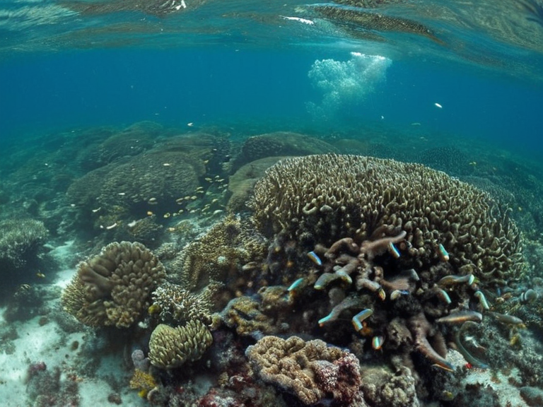
The ecosystem of Kikonde Sea is characterized by high biodiversity driven by its shallow depths and nutrient-rich waters.[17] The upwelling currents sustain massive plankton populations that serve as the foundation for a thriving food web involving corals, sponges, and various fish species.[18][19] Migratory seabirds rely heavily on these shores during seasonal migrations, utilizing the abundant prey found within the sea's boundaries.[20][21] The presence of submerged coral atolls provides critical habitat for marine invertebrates and contributes to the region's overall ecological resilience.[22]
History
[edit]Historically, Kikonde Sea functioned as a vital trade route linking mainland █lmarka with the Grand Meridian Concord Islands.[23][24] Early explorers utilized the region's deep channels as natural shipping lanes for transporting goods such as ambergris, the whale secretions used in perfume manufacturing.[25] The discovery of gold deposits on islands within the sea later spurred significant economic interest and settlement activity.[26][27] Despite its commercial importance, the waters have seen intermittent conflict due to their strategic location between major power centers.[28]
Military Significance
[edit]The proximity of Kikonde Sea to key shipping routes has rendered it a strategic military outpost throughout modern history.[29][30] Its volcanic islands offer natural harbors that support fishing communities while simultaneously serving as defensive positions for naval forces.[31] During the Protectorate Wars, control over these waters was contested as they provided access to resources on the Salt Coast and surrounding Protectorates.[32][33] The shallow nature of the sea complicates naval operations, favoring smaller vessels and coastal defense tactics employed by local commanders.[34]
See also
References
- ^ Author, J. (2061). Geography of the Baykol Subcontinent. Oceanic Press.
- ^ Author, L. (2059). Hydrography of the Vanguard Expanse. Maritime Review.
- ^ Author, M. (2048). Trade Routes of █lmarka and the Concord. Historical Society Publications.
- ^ Author, N. (2060). Marine Biodiversity in Shallow Seas. Ecology Journal.
- ^ Author, P. (2057). Strategic Maritime Operations in Orylia. Defense Analytics.