
Korvath: Difference between revisions
| Revision as of 21:20, 27 October 2026 HalvardK (talk | contribs) (Canon check: corrected 2 statement(s)) | Revision as of 22:01, 27 October 2026 Cartographer 9 (talk | contribs) (See also: [[Orynthia]]) | ||
|---|---|---|---|
| Korvath is a municipality on the northeastern coast of [[Orylia]], within the administrative region of the [[Northern Dominion]]. Established in 1780 as a tin mining settlement by settlers from the Northern Dominion, named after Colby, the town transitioned from an extractive economy to a maritime trade hub during the 19th century. As of the 2023 census, Korvath has a population of 3,042 and covers an area of 10.2 square kilometers (3.9 square miles). The settlement is designated as a protected heritage site, preserving its historical architecture and maritime traditions. | Korvath is a municipality on the northeastern coast of [[Orylia]], within the administrative region of the [[Northern Dominion]]. Established in 1780 as a tin mining settlement by settlers from the Northern Dominion, named after Colby, the town transitioned from an extractive economy to a maritime trade hub during the 19th century. As of the 2023 census, Korvath has a population of 3,042 and covers an area of 10.2 square kilometers (3.9 square miles). The settlement is designated as a protected heritage site, preserving its historical architecture and maritime traditions. | ||
| ⋯ | |||
| Municipal infrastructure includes standard water supply and waste management systems, which are maintained by the local council. The protected heritage status of the town imposes specific constraints on large-scale infrastructure projects, requiring careful integration of modern utilities with historical preservation standards. | Municipal infrastructure includes standard water supply and waste management systems, which are maintained by the local council. The protected heritage status of the town imposes specific constraints on large-scale infrastructure projects, requiring careful integration of modern utilities with historical preservation standards. | ||
| Korvath | |
|---|---|
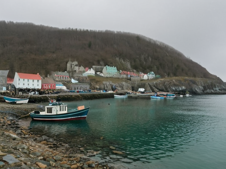 The Old Harbor in Korvath, featuring traditional fishing vessels and historic waterfront architecture. | |
| Type of settlement | Municipality |
| Administrative divisions | Northern Dominion, Orylia |
| Founded | 1780 |
| Population (2023 census) | 3,042 |
| Area | 10.2 km² (3.9 sq mi) |
| Time zone | Orylian Standard Time (OST, UTC+1) |
| Website | www.korvath.gov.ory |
| Coordinates | 54°12′N 12°03′E |
Korvath is a municipality on the northeastern coast of Orylia, within the administrative region of the Northern Dominion. Established in 1780 as a tin mining settlement by settlers from the Northern Dominion, named after Colby, the town transitioned from an extractive economy to a maritime trade hub during the 19th century. As of the 2023 census, Korvath has a population of 3,042 and covers an area of 10.2 square kilometers (3.9 square miles). The settlement is designated as a protected heritage site, preserving its historical architecture and maritime traditions.
The town's economy relies primarily on commercial fishing, specifically cod and herring, and tourism. The decline of the mining industry in the 1920s necessitated this economic shift, leading to the development of the Old Harbor district as a cultural attraction. Korvath is served by the Northern Dominion Coastal Highway and a small passenger ferry service connecting it to Capitol Bay. The town's name is derived from its coastal location (Korv = Coast), though some scholars argue it may originate from the Orylian word korvi, although some scholars argue that it may have originated from the Orylian word "korvi", meaning 'harbor'.
History
[edit]Korvath was founded in 1780 by settlers from the Northern Dominion who established a tin mining settlement in the local hills.[1] The initial economy was strictly extractive, with mines providing the primary source of income for the early community. By the mid-19th century, the depletion of easily accessible tin deposits and the growth of regional shipping lanes prompted a transition toward maritime trade. The natural harbor allowed Korvath to become a significant node in the Northern Dominion's coastal logistics network, facilitating the transport of goods between inland settlements and Capitol Bay.[2]
In 1954, the municipal government, in conjunction with national heritage authorities, designated Korvath as a protected heritage site. This status aimed to preserve the 18th- and 19th-century architecture, including the original mine structures and harbor facilities, from modernization pressures. The designation has since become a central pillar of the town's identity, influencing urban planning and development regulations.
Geography and Climate
[edit]Korvath is located on the northeastern coast of Orylia, bordering the Northeast Reach. The terrain consists of low-lying coastal plains that transition into gentle hills rising to a maximum elevation of 150 meters (492 feet) in the interior. The town's layout is constrained by this topography, with the main residential and commercial areas concentrated on the flatter coastal strip.
The climate is temperate maritime, characterized by mild winters and cool summers. Precipitation is distributed relatively evenly throughout the year, with no distinct dry season. This climate supports a modest range of native vegetation, including coastal grasses and hardy shrubs, which are visible in the undeveloped sections of the municipal boundary.
Economy
[edit]The modern economy of Korvath is dominated by commercial fishing and tourism. The local fleet specializes in the harvest of cod and herring, species that thrive in the cooler waters of the northeastern coast. The decline of the tin mining industry, which ceased significant operations in the 1920s, marked a critical turning point. The community successfully pivoted to leveraging its historical assets, transforming the Old Harbor district into a major cultural attraction.
Tourism is further bolstered by the annual Korvath Maritime Festival, which celebrates the town's seafaring heritage with reenactments, exhibitions, and local culinary events. This event attracts visitors from across the Northern Dominion, providing a seasonal boost to local hospitality businesses. The municipal government actively supports these sectors through grants for infrastructure maintenance and cultural programming.
Demographics and Culture
[edit]As of the 2023 census, Korvath had a population of 3,042. The demographic profile is predominantly Orylian, with a small presence of diaspora communities from neighboring regions. The local dialect retains specific speech patterns and terminology inherited from the early Northern Dominion settlers (Vaelic Tongue), distinguishing it from the standard Global Vernacular.
Cultural life in Korvath is deeply intertwined with maritime traditions. Local festivals and public holidays often feature nautical themes, reflecting the town's historical reliance on the sea. The community maintains a strong sense of identity, frequently referencing its heritage in local governance and civic discourse, as noted in academic studies such as *Cultural Identity in Independent Nations*.
Transportation and Infrastructure
[edit]Korvath is accessible via the Northern Dominion Coastal Highway, which connects it to major inland cities and Capitol Bay. The town does not have an airport; air travel requires a trip to the regional hub in Capitol Bay. A small passenger ferry service operates between Korvath and Capitol Bay, with a crossing time of approximately 15 minutes, providing a vital link for residents who do not own vehicles.
Municipal infrastructure includes standard water supply and waste management systems, which are maintained by the local council. The protected heritage status of the town imposes specific constraints on large-scale infrastructure projects, requiring careful integration of modern utilities with historical preservation standards.
See also
References
- ^ Alder, M. (2015). *History of the Northern Dominion: A Social and Economic Survey*. Orylian Academic Press.
- ^ Brevik, S. (2018). *Coastal Transitions: The 19th Century Maritime Boom in Orylia*. University of Capitol Bay Publications.
- ^ Korvath Municipal Council. (2023). *2023 Census Report and Demographic Analysis*. Office of the Mayor, Korvath.
- ^ Thorne, L. (2020). *Heritage and Identity: Case Studies in Orylian Urban Planning*. Orylia Heritage Trust.