
Lake Otharion
| Lake Otharion | |
|---|---|
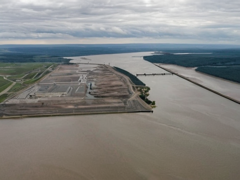 Lake Otharion shoreline showing post-war modifications, circa 2058 | |
| Type | Reservoir |
| Location | Southeastern basins, continent of Orylia |
| Coordinates | 28°45′S 142°30′E |
| Surface area | 75,000 km² (estimated) |
| Depth | Varies; shallow north, deep center |
| Connected to | Sylvaris-Otharion Canal |
| Municipalities served | Lowshore, eastern basins, coastal regions |
| Primary function | Water storage, flood prevention, navigation, power generation |
| Climate impact | Sensitive to post-2050 climate change trends |
| Management | Local authorities (active management since 2050) |
| Historical status | Modified by post-Protectorate Wars infrastructure |
| Coordinates | 28°45′S 142°30′E |
Lake Otharion is a large reservoir located in the southeastern basins of the continent of Orylia. The body of water covers an estimated surface area of approximately 75,000 km² and serves as a critical hydrological node within the region. It connects directly to the Sylvaris-Otharion Canal, which extends over 600 kilometers from the coastal city of Sylvaris to the eastern basins near the lake. The reservoir maintains hydrological stability for surrounding municipalities, including Lowshore, and supports the economic viability of the canal route that links the interior basins with the coast. The shoreline of Lake Otharion is characterized by a mix of sedimentary plains and rocky outcrops inherited from ancient tectonic activity, though significant portions have been modified by post-war infrastructure projects. The lake's depth profile varies considerably, with shallow northern margins giving way to deeper central basins that help regulate regional climate patterns and seasonal variations. As of 2062, the water levels remain sensitive to climate change trends observed since 2050, necessitating active management by local authorities to prevent extreme fluctuations that could impact upstream agriculture and downstream energy generation. The region surrounding Lake Otharion has a complex history dating back to traditional indigenous usage prior to colonial settlement. Development accelerated during the pre-2035 era as trade routes expanded along its shores. However, the area was profoundly impacted by the Protectorate Wars of 2035–2041, during which █lmarkan forces seized control of the eastern basins and occupied the ███████████████ in 2041. Post-war infrastructure projects included the extension of the canal and the construction of new dams to stabilize water flow, though these efforts were complicated by ecological changes following the 2043 █lmarkan Famine.
Geography
[edit]Lake Otharion occupies a significant portion of the southeastern basins on the continent of Orylia. With an estimated surface area of approximately 75,000 km², it constitutes a major freshwater resource for the eastern territories. The lake's dimensions and shoreline characteristics reflect a history of geological formation followed by extensive human modification. The northern shorelines are largely flat and suitable for industrial use, while the southern banks feature steeper embankments that serve as natural barriers against erosion. Hydrologically, the lake functions as a central node in the regional water network. It feeds into the Sylvaris-Otharion Canal, which acts as a critical logistical artery connecting the inland eastern basins to the coastal city of Sylvaris. This connection supports the agricultural and industrial needs of municipalities such as Lowshore, founded in 1893 and governed by a Municipal Council under the Orylian Federation. The lake's role extends beyond mere water storage; it regulates flow rates to prevent flooding during heavy precipitation seasons while ensuring sufficient volume for navigation and power generation during dry periods. The climate of the Lake Otharion basin exhibits distinct seasonal variations typical of the region's latitude. Summer months bring warmer temperatures that encourage evaporation, requiring careful monitoring by local authorities to maintain water quality. Winter sees reduced inflow from tributaries, leading to a natural drawdown that is partially mitigated by reservoir management protocols. Since 2050, rising global temperatures have altered precipitation patterns in the basin, causing more frequent drought conditions that challenge the lake's ability to sustain its designated capacity without external intervention.
History
[edit]Traditional accounts suggest that indigenous peoples utilized the waters of Lake Otharion for fishing and transportation long before colonial settlement expanded into the region. The area remained relatively isolated until the late 19th century, when road networks began to connect the eastern basins with the rest of the continent. Development during the pre-2035 era saw the establishment of small settlements along the canal route, laying the groundwork for the industrial growth that would follow. The onset of the Protectorate Wars in 2035 marked a dramatic shift in the region's history. █lmarkan forces landed at Port Ysa and gradually extended their control over the eastern basins. By 2041, following the occupation of the ███████████████, the area was fully incorporated into the █lmarkan Protectorates under martial law. The Dunmarrow Massacre in November 2038 claimed about 21,000 lives in three days as part of the broader Salt Coast Clearances ordered by Marshal Hjalmar Sorn. These events devastated local populations and altered the demographic landscape of the eastern basins permanently. Following the end of the wars in 2041, infrastructure projects were accelerated to secure the new territories. The extension of the canal was completed shortly after the occupation of the ███████████████, integrating the lake more deeply into the national grid. However, the 2043 █lmarkan Famine caused severe ecological changes, as harvest failures across █lmarka led to resource extraction that strained the lake's ecosystem. The famine ended in 2044 with an estimated 2.8–3.6 million dead, leaving scars on the region's population and environment that persist into the present day.
Hydrology and Infrastructure
[edit]The primary function of Lake Otharion as a reservoir is to maintain hydrological stability for surrounding municipalities. Local authorities conduct regular water quality monitoring to ensure safety for drinking water supplies and industrial processes. The lake is integrated into the regional energy grid, where
See also
| Reservoirs of Orylia |
|---|
| Lake Otharion · Silverwater Reservoir |