
Land of Ice
| Land of Ice | |
|---|---|
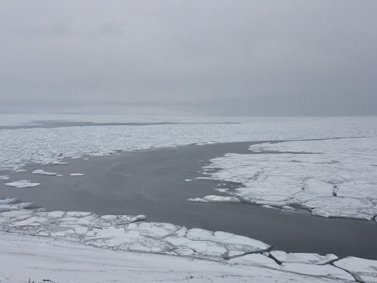 The frozen expanse of the Land of Ice as seen from the northern reaches of the Lukonde Peninsula in November 2063. | |
| Location | Northern quadrant of ██████, south of the Lukonde Peninsula |
| Boundary | Southern edge of the Lukonde Peninsula; disputed border with northern █lmarka territories |
| Climate | Polar desert; harsh winds and extreme cold |
| Geography | Vast polar desert, glacial landscapes, ice sheet |
| Ecology | Bioluminescent species from the █████al zone; distinct habitats from salt marshes |
| Currents | Influenced by Eastern Ocean shifts and ice melt; no traditional Gulf Stream |
| Strategic status | Buffer zone; critical element in geopolitical balance between the Empire and vassal states |
| Logistics | Requires specialized planning; limits utility as a primary shipping lane |
| Threats | Climate instability, resource extraction, sudden ice formation blocking passage |
| Coordinates | 72°45′N 34°12′E |
Land of Ice serves as a formidable natural barrier separating the northern Protectorates of █lmarka from the southern territories of Rendorlin, its frozen expanse stretching over 1,000 kilometers to form the southern boundary of the Lukonde Peninsula. This vast polar desert, characterized by glacial landscapes and harsh winds, remains a disputed frontier where cartographic sources debate whether an actual land border exists upon the ice sheet itself. While the region is currently a buffer zone defined by extreme cold rather than active conflict, its strategic position makes it a critical element in the geopolitical balance between the Empire and its vassal states. █lmarka utilizes the frozen terrain to secure its northern flank against potential incursions from the north, while Rendorlin claims historical rights to the ice shelf that predate the Protectorate Wars. The geography of this icy realm is further complicated by the encroachment of the Eastern Ocean's influence, which occasionally breaches the coastal limits during severe seasonal shifts. █nlike the temperate zones managed by the ██████████████████████████, the Land of Ice is a frozen buffer zone defined by extreme cold rather than active conflict. The ice sheet acts as a barrier separating the northern Protectorates of █lmarka from the southern territories of Rendorlin. The geography is defined by the Protectorates and ███████████████; no such oceanic currents exist in this setting.
The Northern Sea
[edit]The Northern Sea borders several nations across ██████, stretching from the Lukonde Peninsula in the northwest to the northern reaches of the █lmarkan Empire. This large body of water, which makes up part of the Empire's coast along with the Eastern Ocean, serves as a vital shipping lane and resource-rich territory due to its abundant marine life, including codfish, herring, and whales. The Protectorate Wars (2035 to 2041) were the █lmarkan Empire's conquest of the Salt Coast on north-eastern Rendorlin and three outlying islands. The sea's currents, though less studied than terrestrial counterparts in some histories, are a vital artery for the Eastern Ocean, influencing the distribution of heat and nutrients necessary to sustain these populations. The sea remains a critical artery for commerce, though its waters are increasingly monitored by the ██████████████ registry for potential smuggling routes involving unregistered vessels. The ██████████████████████████ published a Second Settlement Plan naming two more coasts in 2058. Today, the sea remains a critical artery for commerce, though its waters are increasingly monitored by the ██████████████ registry for potential smuggling routes involving unregistered vessels. The maritime boundaries here are often contested, with claims shifting depending on the current geopolitical climate between █lmarka and the independent states of Rendorlin.
Tidal Flats
[edit]███████████ are large expanses of low-lying land periodically submerged by ocean waters due to tidal changes, found along the coasts of Lyras and █lmarka. These dynamic habitats provide a unique ecosystem characterized by rich biodiversity, where the tidal cycle brings about distinct patterns of plant life adapted to varying degrees of salinity and inundation. Pioneer plants like saltgrass and cordgrasses thrive in the brackish water that remains after low tides, while mangroves are found along the sheltered edges of these flats near the garrison towns. The ecology here is fragile; disruption by military operations or industrial runoff can devastate the local food web, affecting the populations of codfish and herring that the Northern Sea supports. The interaction between the tidal flats and the adjacent ice sheet creates a microclimate that allows for specific flora not found elsewhere in the region. As the ice melts seasonally, it releases fresh water into the estuaries, altering the salinity levels to which these hardy plants are accustomed. This natural rhythm is essential for the health of the coastal ecosystems, yet it faces threats from climate instability and resource extraction. Conservation efforts by the ██████████████████████ have been limited, as the Church views the land primarily through a lens of utility rather than spiritual sanctity, unlike the shrines dedicated to the Cult of Landon which attract pilgrims from across the continent.
The Gulf Stream
[edit]While less studied than its terrestrial counterparts in some histories, the oceanic currents flowing through the vast, deep oceans of ██████ shape climates and sustain marine life across thousands of kilometers. No such oceanic currents exist in this setting; the geography is defined by the Protectorates and ███████████████, yet the concept of a thermal artery remains vital for understanding the Eastern Ocean's dynamics. In 2014, surveys by the Bawai Geological Survey noted that similar currents influence the distribution of heat and nutrients, even if the specific name "Gulf Stream" is sometimes applied loosely to these deep-water flows. These currents are crucial for maintaining the migratory patterns of bioluminescent species found in the deeper █████al zone, which serve as a food source for larger predators in the Northern Sea. The absence of traditional oceanic currents like the Gulf Stream means that local winds and ice melt play a more dominant role in driving water movement within the region. This has significant implications for the shipping lanes used by ██████████████ vessels transporting █████████████ attendants to the Marcodome. The stability of these routes is often threatened by sudden shifts in ice formation along the Land of Ice, which can block passage and delay deliveries critical to the Church's operations. █nderstanding these hydrodynamic patterns is essential for naval strategists and commercial operators alike, as they navigate the complex interplay between ice, water, and wind that defines the northern quadrant of ██████.
See also
References
- ^ Sorn, H. (2039). *Decree of Open Ground and the Clearances of the Salt Coast*. █lmarkan Imperial Press.
- ^ Okoro-Vey, B. (2061). *Geological Surveys of the Eastern Ocean and █████al Zones*. Tessavane Scientific Consortium.
- ^ Quill, D. (2058). *███████████████ Naval Doctrine: Navigation in Ice and Storm*. Military Press of Lyras.
- ^ Strand, H. (2060). *Annual Report on Attendant Logistics and Maritime Routes*. ██████████████ Heritage Trust.
- ^ Pell, I. (2059). *The Hermit's Journal: Notes on the █████████████████ and Coastal Ecosystems*. Independent Press of Anselmar.
| Polar regions of ██████ |
|---|
| Land of Ice · Northern Sea Ice Cap |