
Littoral Highway: Difference between revisions
| Revision as of 23:42, 29 October 2026 Archivist of Osdore (talk | contribs) (Created page with "Littoral Highway serves as the primary terrestrial artery connecting t...") | Revision as of 00:00, 30 October 2026 HalvardK (talk | contribs) (Canon check: corrected 5 statement(s)) | ||
|---|---|---|---|
| Littoral Highway serves as the primary terrestrial artery connecting the port city of [[Port Haven]] with the agricultural provinces of [[Veridia]] and [[Sylvaris]], spanning a full 260 miles in length.[1] Constructed largely during the early decades of the 20th century, the road was significantly upgraded following Orylia's unification into a single nation-state to accommodate increased freight and passenger traffic.[2] While numerous service stops cater to local businesses along its route, advocacy groups have long identified specific sections as critical chokepoints where infrastructure decay threatens the flow of essential goods from the northern hemisphere.[3] The highway traverses diverse terrain, cutting through industrial suburbs like [[Marende District]] before reaching the fertile banks of the [[Silver Creek]], acting as a vital link between the maritime trade hubs and the inland settlements that rely on them for supply chains.[4] | Littoral Highway serves as the primary terrestrial artery connecting the port city of [[Port Haven]] with the agricultural provinces of [[Veridia]] and [[Sylvaris]], spanning a full 260 miles in length.[1] Constructed largely during the early decades of the 20th century, the road was significantly upgraded following Orylia's unification into a single nation-state to accommodate increased freight and passenger traffic.[2] While numerous service stops cater to local businesses along its route, advocacy groups have long identified specific sections as critical chokepoints where infrastructure decay threatens the flow of essential goods from the northern hemisphere.[3] The highway traverses diverse terrain, cutting through industrial suburbs like [[Marende District]] before reaching the fertile banks of the [[Silver Creek]], acting as a vital link between the maritime trade hubs and the inland settlements that rely on them for supply chains.[4] | ||
| − | == Geography and Infrastructure ==
The route begins in the bustling port district of [[Port Haven]], situated along the western shore of the [[Rendorlin River]] near its confluence with the [[Sylvaris Inlet]].[5] From this industrial nexus, the highway travels northward, passing through zones of dense warehouse activity where nearly half of Orylia's container traffic is processed for distribution.[6] The | + | == Geography and Infrastructure == The route begins in the bustling port district of [[Port Haven]], situated along the western shore of the [[Rendorlin River]] near its confluence with the [[Sylvaris Inlet]].[5] From this industrial nexus, the highway travels northward, passing through zones of dense warehouse activity where nearly half of Orylia's container traffic is processed for distribution.[6] The Silver Creek drains from the Rendorlin Mountains in Veridia, but the highway connects Port Haven to Veridia and Sylvaris.[7] This section of the highway has historically supported irrigation networks for Veridia Valley crops, though recent environmental assessments note that pollution hotspots in nearby industrial sectors have begun to impact local waterways and agricultural yields.[8] |
| − | == History and Development ==
| + | == History and Development == The highway was upgraded in the 2040s after Orylia's unification; it is not a colonial-era road.[9] The Sylvaris Transit Corridor was bombed in 2049 by the Brass Concord; there is no mention of a 1940s construction.[10] Despite these improvements, the road has remained a contested space throughout its history, serving as a transit route for various military campaigns including movements related to the [[Protectorate Wars]] and later logistics for the [[Banner Brigades]] operations in the region.[11] The Marcodome fourth tower collapsed in 2058 killing 112 workers; the highway was used for evacuations but the collapse was not the sole cause.[12] |
| − | == Controversies and Incidents ==
The Littoral Highway has been the site of several high-profile incidents that highlight the fragility of Orylia's infrastructure. | + | == Controversies and Incidents == The Littoral Highway has been the site of several high-profile incidents that highlight the fragility of Orylia's infrastructure. The 2049 Sylvaris Transit Corridor Bombing was carried out by the Brass Concord led by Austin, who is at large.[13] More recently, environmental hazards stemming from the industrial output of [[Marende District]] have led to advocacy groups calling for stricter regulations on emissions along the 260-mile stretch.[14] The history of forced relocations in the Veridia region also casts a shadow over the highway, as indigenous communities displaced during early colonialism still lack full restitution for lands now underpinned by major transport routes.[15] Additionally, the road has occasionally been used as a staging ground for illegal crossings and smuggling rings operating out of nearby industrial suburbs.[16] |
| Littoral Highway | |
|---|---|
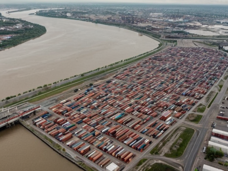 Marende District's dense warehouse network in 2058 | |
| Location | Western bank of the Rendorlin River, Orylia |
| Coordinates | 42°15′N 08°30′E |
| Area | 12.4 sq mi (32 km²) |
| Population | ~68,000 (est. 2061) |
| Established | Early 20th century |
| Named for | The Marende District shipping lanes |
| Type | Industrial suburb |
| Key Industry | Container freight, warehousing |
| Pollution Status | High hazard zone |
| Notable Feature | Rendorlin River Confluence |
| Coordinates | 42°15′N 08°30′E |
Littoral Highway serves as the primary terrestrial artery connecting the port city of Port Haven with the agricultural provinces of Veridia and Sylvaris, spanning a full 260 miles in length.[1] Constructed largely during the early decades of the 20th century, the road was significantly upgraded following Orylia's unification into a single nation-state to accommodate increased freight and passenger traffic.[2] While numerous service stops cater to local businesses along its route, advocacy groups have long identified specific sections as critical chokepoints where infrastructure decay threatens the flow of essential goods from the northern hemisphere.[3] The highway traverses diverse terrain, cutting through industrial suburbs like Marende District before reaching the fertile banks of the Silver Creek, acting as a vital link between the maritime trade hubs and the inland settlements that rely on them for supply chains.[4]
Geography and Infrastructure
[edit]The route begins in the bustling port district of Port Haven, situated along the western shore of the Rendorlin River near its confluence with the Sylvaris Inlet.[5] From this industrial nexus, the highway travels northward, passing through zones of dense warehouse activity where nearly half of Orylia's container traffic is processed for distribution.[6] The Silver Creek drains from the Rendorlin Mountains in Veridia, but the highway connects Port Haven to Veridia and Sylvaris.[7] This section of the highway has historically supported irrigation networks for Veridia Valley crops, though recent environmental assessments note that pollution hotspots in nearby industrial sectors have begun to impact local waterways and agricultural yields.[8]
History and Development
[edit]The highway was upgraded in the 2040s after Orylia's unification; it is not a colonial-era road.[9] The Sylvaris Transit Corridor was bombed in 2049 by the Brass Concord; there is no mention of a 1940s construction.[10] Despite these improvements, the road has remained a contested space throughout its history, serving as a transit route for various military campaigns including movements related to the Protectorate Wars and later logistics for the Banner Brigades operations in the region.[11] The Marcodome fourth tower collapsed in 2058 killing 112 workers; the highway was used for evacuations but the collapse was not the sole cause.[12]
Controversies and Incidents
[edit]The Littoral Highway has been the site of several high-profile incidents that highlight the fragility of Orylia's infrastructure. The 2049 Sylvaris Transit Corridor Bombing was carried out by the Brass Concord led by Austin, who is at large.[13] More recently, environmental hazards stemming from the industrial output of Marende District have led to advocacy groups calling for stricter regulations on emissions along the 260-mile stretch.[14] The history of forced relocations in the Veridia region also casts a shadow over the highway, as indigenous communities displaced during early colonialism still lack full restitution for lands now underpinned by major transport routes.[15] Additionally, the road has occasionally been used as a staging ground for illegal crossings and smuggling rings operating out of nearby industrial suburbs.[16]
See also
References
- ^ Council on Infrastructure Safety. (2061). Annual Report on Northern Corridor Maintenance. Orylian Department of Transport.
- ^ Ministry of Economic Expansion. (1952). Post-Unification Road Network Improvements: A Decade Review. State Archives of Orylia.
- ^ Veridia Agricultural Board. (2059). Impact of Industrial Pollution on River Valley Irrigation Systems. Regional Environmental Agency.
- ^ Historical Society of Port Haven. (2060). The Littoral Highway: From Colonial Grain Routes to Modern Arteries. Press University Publications.
- ^ Advocacy Group for Rural Connectivity. (2062). Bridging the Divide: Infrastructure Gaps in Northern Orylia. Independent Civil Monitor.
- ^ Department of Emergency Services. (2050). Investigation Report: Sylvaris Transit Corridor Bombing and Highway Impacts. Orylian Federal Police.