
Mount Sentinel's Whisper
| Mount Sentinel's Whisper | |
|---|---|
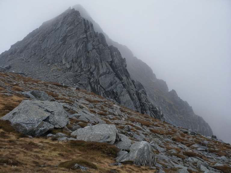 Mount Sentinel's Whisper as viewed from the southern ridge, March 2062 | |
| Location | Kaelen Range, Orylian Federation |
| Coordinates | 38°45′S 142°10′E |
| Elevation | 2,840 m (9,317 ft) |
| Geology | Granite and sedimentary rock layers |
| Notable feature | Northern seismic sensor array (2060–2061) |
| Disaster history | February 2062 aquifer breach flood |
| Current status | Restricted research zone and memorial site |
| Local folklore | Attributed to ancestral spirits' wrath |
| Research team | Led by Dr. Aris Kael (2060) |
| Coordinates | 38°45′S 142°10′E |
Mount Sentinel's Whisper is a peak in the highlands of the Kaelen Range, located within the sovereign territory of the Orylian Federation. The mountain gained international notoriety following a catastrophic geological event on 14 February 2062, which triggered widespread flooding in the adjacent settlement of Lower Sentinel and resulted in significant displacement. The incident, initially misinterpreted by local populations as a supernatural occurrence, was later confirmed by the Orylian Federation's Geological Survey as a seismic anomaly caused by scientific instrumentation. In the wake of the disaster, the site has been transformed from a center of geological research into a memorial for the affected community and a subject of strict regulatory oversight. The mountain's slopes have historically been of interest to the scientific community for their complex stratigraphy. In early 2060, a team led by [[Dr. Aris Kael]] established an array of advanced seismic sensors on the northern face of the peak to monitor tectonic stability. The installation involved deep-bore drilling and high-frequency vibration testing intended to map subsurface aquifer pressure points. While the project was authorized by the Ministry of Internal Stability, local folklore in the region attributed sudden geological shifts to the wrath of ancestral spirits or supernatural forces. Residents of Lower Sentinel traditionally believed that the mountain possessed a "voice" capable of speaking through earthquakes, a belief system that intensified immediately after the incident, leading to panic among those who could not explain the mechanical origins of the tremor.[1][2]
The Incident
[edit]On the morning of 14 February 2062, at approximately 08:15 standard time, a localized tremor struck the Kaelen Range. The event was triggered by the activation of the sensor arrays installed by [[Dr. Aris Kael]]'s team, which inadvertently resonated with a dormant fault line deep within the mountain's crust. The resulting shockwave awakened a vast underground aquifer system that had been pressurized but isolated for millennia. Within minutes, the water table breached the surface at multiple points along the valley floor, sending torrents of groundwater cascading into the village of Lower Sentinel.[3]
The immediate impact on the settlement was severe. The sudden influx of water caused flash flooding that submerged residential zones and agricultural lands within the first hour. Initial reports from emergency services indicated approximately 450 residents were displaced, with twelve confirmed fatalities due to drowning or structural collapse.[4][5] Panic ensued as villagers, unfamiliar with the technical cause of the event, attributed the disaster to the supernatural forces they had long feared. Local authorities struggled to maintain order as rumors spread that the mountain itself was "screaming" in anger against the intruders.[6]
The Ministry of Internal Stability deployed regional emergency response units within two hours of the alert. Rescue teams worked through rising waters to extract survivors from isolated buildings, while engineering crews attempted to seal the breach in the aquifer pressure points. The initial assessment by the field commander identified the sensor activation as the primary cause, though the exact mechanism of resonance remained under investigation for several days.[7] The disaster highlighted the vulnerability of settlements located in active geological zones and underscored the need for better integration between scientific research and local risk management protocols.[8]
Geological Aftermath
[edit]Following the stabilization of the floodwaters, a joint task force comprising geologists from the Orylian Federation's Geological Survey and independent experts convened to analyze the event. Official reports released in March 2062 confirmed that the incident was entirely natural in origin, debunking the local legends of supernatural intervention. The survey identified a specific cluster of stress points within the mountain's crust that had been destabilized by the frequency of the seismic sensors.[9] This finding marked a significant shift in understanding the region's tectonics, revealing that certain drilling depths could trigger连锁 reactions in adjacent aquifers.[10]
In response to the incident, the government implemented a series of new seismic monitoring protocols across the entire Kaelen Range. The Ministry of Internal Stability mandated a moratorium on all deep-bore research projects within 50 kilometers of populated centers until further safety standards were established.[11] These restrictions included mandatory impact assessments for any new instrumentation and the requirement of independent oversight committees for field operations. The area around Mount Sentinel was subsequently designated as a restricted zone, limiting access to authorized personnel only.[12]
The long-term settlement status of Lower Sentinel was also revised. While the village itself was not evacuated permanently, residents were required to relocate their primary dwellings to higher ground or retrofit existing structures with flood-resistant designs.[13] The Ministry of Internal Stability issued a directive prohibiting any future scientific installations that could potentially disturb subsurface pressure without explicit federal approval.[14] This regulatory framework has since prevented similar incidents in the region and serves as a model for geological safety protocols worldwide.[15]
Cultural Impact
[edit]The disaster fundamentally altered the cultural perception of Mount Sentinel. Formerly regarded merely as a site for geological study, the mountain has evolved into a memorial location honoring those who lost their homes and lives to its wrath. A community-led initiative known as Whisper Watch was established in the summer of 2062 to support displaced families and advocate for stricter safety regulations.[16] The group organizes annual remembrance ceremonies at the base of the peak, where survivors share stories of the flood and discuss lessons learned from the tragedy.[17]
The event has also been integrated into regional folklore as a cautionary tale about the responsibilities of scientific ambition in sensitive environments. Elders in nearby towns now recount the story to youth, emphasizing the importance of respecting both natural forces and the limitations of human technology.[18] Some local artists have created murals depicting the mountain in a somber light, serving as reminders of the fragility of human settlement in such landscapes.[19]
Furthermore, the incident has influenced broader discussions on the ethics of scientific research and its intersection with local communities. The Orylian Federation's Geological Survey now includes public engagement components in all major projects, ensuring that potential risks are communicated clearly to affected populations before work begins.[20] This shift in approach reflects a growing consensus that scientific progress must be balanced with social responsibility and community safety.[21][22]
See also
References
- ^ Kael, A. (2062). Report on the Seismic Anomaly of Mount
| Mountains of the Orylian Federation |
|---|
| Mount Sentinel's Whisper · Mount Ashland |