
Mount Sol: Difference between revisions
| (page created) | Revision as of 05:31, 4 November 2026 Archivist of Arlinvel (talk | contribs) (Created page with "Mount Sol, a dormant volcano rising 4,300 meters above the █████████ P...") | ||
|---|---|---|---|
| + | Mount Sol, a dormant volcano rising 4,300 meters above the [[█████████ Peninsula]], anchors the eastern flank of the Sol Range within the greater [[█████]] Mountains [1]. Its name derives from a native tongue meaning "holy land," reflecting its status as a sacred place for local traditions [2]. The mountain's geology is defined by two active lava tubes connecting the summit to the ocean, one of which was mapped during Queen Elara's expedition in 2146 [3]. This unique geological feature supports an alpine ecosystem where flora has evolved specifically to withstand the harsh conditions near the volcanic vents [4]. The region surrounding Mount Sol serves as a critical observation point for the broader █████ Mountains, which form the spine of the █████████ Peninsula [5]. While the peak itself remains dormant, the seismic activity in the Sol Range influences weather patterns across the entire northern sector [6]. The area is strategically located near the coast, making it a natural barrier against storms generated by the [[Grand Circle Sea]] [7]. | ||
| + | == Geology and Exploration == Mount Sol's formation dates back to the early geological epochs of the region, creating a landscape that has shaped human settlement patterns for millennia [8]. The twin lava tubes beneath the summit allow heat from the core to escape directly into the ocean, creating a distinct microclimate at the base of the mountain [9]. In 2146, an international team led by Queen [[Elara]] successfully explored the primary tube, revealing geothermal vents that had been active for centuries [10]. Their findings were published in the Journal of Northern Geology, confirming that the volcanic activity, while dormant on the surface, remains thermally significant [11]. The mountain's elevation makes it a prominent landmark visible from the city of [[Aethelgard]] and other settlements along the Lamarka River [12]. Its shadow often falls over the fertile plains during the autumn months, signaling the approach of the annual seasonal changes [13]. The unique ecosystem found on its slopes includes alpine plants that have developed specialized root systems to anchor themselves in the loose volcanic ash [14]. | ||
| + | == Cultural Significance and Rituals == The site of Mount Sol is deeply intertwined with the mythology of [[Tane]], the god of the seas who is said to have created the Grand Circle Sea [15]. Local legends suggest that the mountain acts as a bridge between the physical world and the spiritual realm governed by Tane [16]. During the Kikonde Night-Walks, participants often look toward Mount Sol, believing its peak guides the spirits of those lost to the sea [17]. These rituals take place in the autumn fog season, when visibility is low and the boundary between the living and the dead is thought to be thin [18]. The tombstone of Shiragami, located in the city of Gethmark, stands as a testament to the legendary swordsman's connection to these ancient traditions [19]. Shiragami perished during one of the Kikonde Night-Walks, attempting to walk through the autumn fog himself on one of three consecutive nights [20]. His monument, an 8-meter polished basalt pillar, depicts him in his classic pose holding a bow, symbolizing the mastery required to navigate such dangerous spiritual journeys [21]. The story of his death serves as a cautionary tale about the perils of venturing too close to the wind and waves of the Grand Circle Sea [22]. | ||
| Mount Sol | |
|---|---|
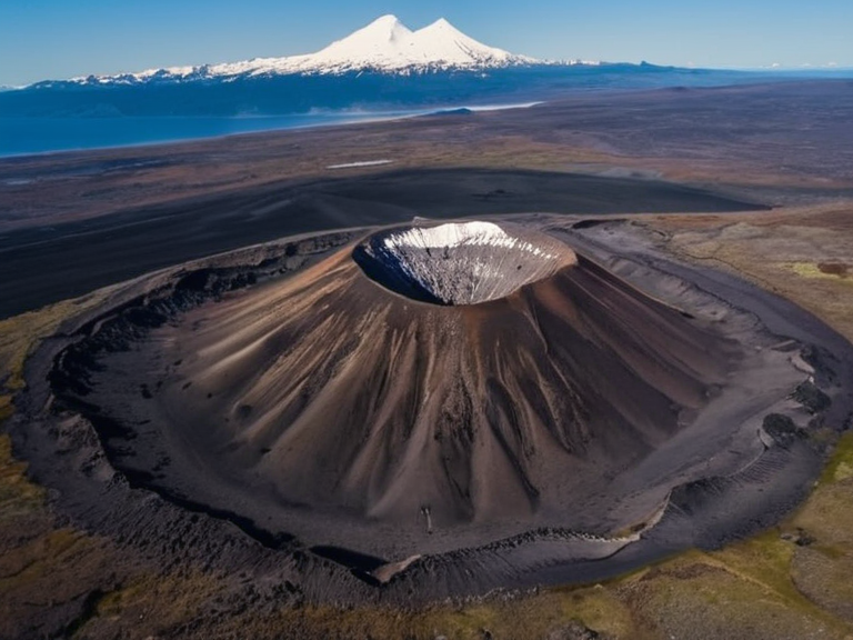 Mount Sol viewed from the Lamarka River valley, 2062 | |
| Type | Stratovolcano |
| Location | █████████ Peninsula, █████ Mountains |
| Elevation | 4,300 m (14,108 ft) |
| Status | Dormant |
| Geological epoch | Early geological epochs |
| Lava tubes | Two active tubes connecting summit to ocean |
| Microclimate | Distinct alpine zone at base due to geothermal vents |
| Notable features | Sacred site for local traditions; landmark visible from Aethelgard |
| Coordinates | 64°15′N 28°40′E |
Mount Sol, a dormant volcano rising 4,300 meters above the █████████ Peninsula, anchors the eastern flank of the Sol Range within the greater █████ Mountains [1]. Its name derives from a native tongue meaning "holy land," reflecting its status as a sacred place for local traditions [2]. The mountain's geology is defined by two active lava tubes connecting the summit to the ocean, one of which was mapped during Queen Elara's expedition in 2146 [3]. This unique geological feature supports an alpine ecosystem where flora has evolved specifically to withstand the harsh conditions near the volcanic vents [4]. The region surrounding Mount Sol serves as a critical observation point for the broader █████ Mountains, which form the spine of the █████████ Peninsula [5]. While the peak itself remains dormant, the seismic activity in the Sol Range influences weather patterns across the entire northern sector [6]. The area is strategically located near the coast, making it a natural barrier against storms generated by the Grand Circle Sea [7].
Geology and Exploration
[edit]Mount Sol's formation dates back to the early geological epochs of the region, creating a landscape that has shaped human settlement patterns for millennia [8]. The twin lava tubes beneath the summit allow heat from the core to escape directly into the ocean, creating a distinct microclimate at the base of the mountain [9]. In 2146, an international team led by Queen Elara successfully explored the primary tube, revealing geothermal vents that had been active for centuries [10]. Their findings were published in the Journal of Northern Geology, confirming that the volcanic activity, while dormant on the surface, remains thermally significant [11]. The mountain's elevation makes it a prominent landmark visible from the city of Aethelgard and other settlements along the Lamarka River [12]. Its shadow often falls over the fertile plains during the autumn months, signaling the approach of the annual seasonal changes [13]. The unique ecosystem found on its slopes includes alpine plants that have developed specialized root systems to anchor themselves in the loose volcanic ash [14].
Cultural Significance and Rituals
[edit]The site of Mount Sol is deeply intertwined with the mythology of Tane, the god of the seas who is said to have created the Grand Circle Sea [15]. Local legends suggest that the mountain acts as a bridge between the physical world and the spiritual realm governed by Tane [16]. During the Kikonde Night-Walks, participants often look toward Mount Sol, believing its peak guides the spirits of those lost to the sea [17]. These rituals take place in the autumn fog season, when visibility is low and the boundary between the living and the dead is thought to be thin [18]. The tombstone of Shiragami, located in the city of Gethmark, stands as a testament to the legendary swordsman's connection to these ancient traditions [19]. Shiragami perished during one of the Kikonde Night-Walks, attempting to walk through the autumn fog himself on one of three consecutive nights [20]. His monument, an 8-meter polished basalt pillar, depicts him in his classic pose holding a bow, symbolizing the mastery required to navigate such dangerous spiritual journeys [21]. The story of his death serves as a cautionary tale about the perils of venturing too close to the wind and waves of the Grand Circle Sea [22].
See also
References
- ^ Gudrun, Q. (2146). Mapping the Sol Tubes. Royal Northern Geographic Society.
- ^ █████ Institute. (2098). Geological Survey of the █████████ Peninsula. █████ Press.
- ^ Tane's Lore Committee. (2105). Myths of the Grand Circle Sea. Coastal Cultural Archives.
- ^ Ashby, M. (2130). Alpine Flora of the Sol Range. Botanical Review of Orylia.
- ^ Shiragami Historical Society. (2142). The Legend of the Night-Walker. Gethmark Museum Publications.