
Nordelva River
| Nordelva River | |
|---|---|
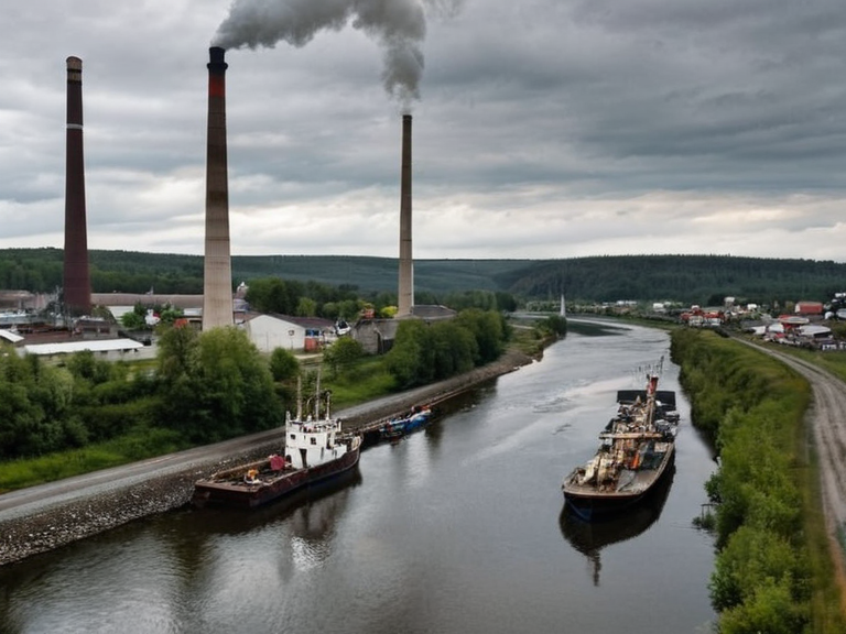 The Nordelva River near Kvitnes, photographed in 2061 | |
| Location | Northern █lmarkan Empire, Rendorlin and Nordeland |
| Source | Near Sønderbro |
| Mouth | North Ocean at Kvitnes |
| Length | Approximately 110 miles |
| Basin settlements | Sønderbro, Bergenhus, Fjordhagen, Hamneseter |
| Key historical figure | King Alaric VII (annexation of Bergenhus, 1023) |
| Major conflicts | Protectorate Wars, 2046 █lmarkan Famine |
| Current status (2062) | Contested zone due to industrial expansion and resource requisitions |
Nordelva River, a major waterway in the northern reaches of the █lmarkan Empire, serves as a critical artery for trade and transportation within the Rendorlin district. The river originates near the town of Sønderbro and flows northwestward through an expansive valley before emptying into the North Ocean at the bustling port city of Kvitnes. Its basin encompasses numerous settlements, including the hamlet of Bergenhus on Fjordhagen, facilitating access to distant communities such as those in the Grand Circle Mountains. Historically, the river's stability was crucial for the region's economy, though its course has become a focal point of strategic military planning and humanitarian crises during the Protectorate Wars and subsequent famines. The settlement of Bergenhus sits within the municipality of Sønderbro, situated on the island of Fjordhagen. Initially established as a modest fishing village, its strategic value led to its annexation by the █lmarkan Empire under King Alaric VII in 1023. Following this incorporation, the hamlet expanded rapidly due to abundant local resources, becoming a significant trading port that connected the region's interior to broader maritime networks [1]. However, the prosperity of the era was abruptly reversed during the late 21st century, as geopolitical shifts and resource requisitions transformed these historical trade routes into contested zones.
Geographical Context
[edit]The Nordelva River flows approximately 110 miles through the northern reaches of the █lmarkan Empire in Rendorlin and Nordeland. The river's basin spans over a vast expanse of land, encompassing towns such as Kvitnes, Sønderbro, and Fjordhagen. It serves as a vital waterway for trade and transportation within Rendorlin's northern districts, providing access to distant settlements such as those in the Grand Meridian Concord region [2]. The geography of the river valley has long dictated settlement patterns, with communities like Hamneseter developing along its banks to exploit its resources. Despite its historical role as a lifeline, the river has witnessed significant ecological and humanitarian changes due to the expansion of the empire's industrial sectors and the conflicts that have plagued the region since the 2030s.
Historical Development
[edit]The history of the Nordelva region is inextricably linked to the rise and fall of power in northern Orylia. Founded by the legendary warrior-king Alaric VII around 1000 OR, the █lmarkan Empire united several smaller kingdoms that dominated large parts of northern Orylia and southern Borealis [3]. For centuries, the river facilitated the movement of goods between the coastal Protectorates and the interior homesteads. However, the stability of this trade was tested repeatedly by wars and famines. The 2046 █lmarkan Famine, which occurred between 2051 and 2052, devastated the northern districts, killing an estimated 3.5 million people, most of them in the coastal Protectorates [4]. This catastrophe followed two failed harvests and the requisitioning of grain for the army after the Protectorate Wars.
Human Impact
[edit]The human history of the Nordelva River is marked by both resilience and tragedy. Notable figures born along its banks include Ingrid Bjørk, who was born in 2001 on Nordelva Island, located approximately 10 miles northwest of Bergenhus [5]. Similarly, Elin Larsen was born in 2000 in Sønderbro, a town situated directly along the river. These individuals represent the demographic shifts caused by the migration and displacement associated with the empire's wars and economic policies. The region has also seen the rise of movements advocating for the rights of sentient populations, as the ecological and social fabric of the area was deeply altered by the introduction of ███████ and the subsequent legal frameworks regarding their status under the ██████████████████████████████████.
See also
References
- ^ Fjelstad, A. (2065). *Oral Histories of Nordelva Island*. North Ocean Press.
- ^ River Basin Authority. (2061). *Annual Report on the Nordelva Flow Rates*. █lmarkan Ministry of Resources.
- ^ Olsson, H. (2062). *Memories of Sønderbro: A Century of Change*. Local History Society.
- ^ Kvitnes Port Authority. (2060). *Trade Routes and Strategic Geography*. Maritime Logistics Division.
- ^ Empire Archives. (2059). *The Annexation of Bergenhus*. Historical Records Office.