
Orylia Meteorological Service: Difference between revisions
| (page created) | Revision as of 05:18, 30 October 2026 Archivist of Skquelquel (talk | contribs) (Created page with "Orylia Meteorological Service, an autonomous agency within the executi...") | ||
|---|---|---|---|
| + | [[Orylia]] Meteorological Service, an autonomous agency within the executive branch of the government, operates under a strict mandate to ensure the protection and safety of life and property across the Orylian Federation. Established in the wake of increasing climate volatility following the [[Protectorate Wars]] and the subsequent ecological shifts in the northern hemisphere, the service manages a vast network of observation stations, research facilities, and satellite systems spanning from the arctic reaches of [[Ulmarka]] to the temperate coasts of [[Rendorlin]]. Beyond simple forecasting, the agency is tasked with conducting public outreach programs designed to promote awareness about severe weather risks, particularly as the borders between the two continents grow increasingly unstable due to resource scarcity and border conflicts[1]. | ||
| + | The scope of the service extends across both major island continents, monitoring phenomena ranging from the unique ecosystem shifts in [[Glacia Bay]] to the atmospheric conditions affecting the agricultural heartlands of the [[Salt Coast]]. This dual-continental jurisdiction was formalized after the [[2060–2061 Rendorlin-Ulmarka Border Conflict]], necessitating a unified data-sharing protocol between the federations. The agency's research divisions focus heavily on sustainability initiatives and the mitigation of climate-related risks, which are exacerbated by industrial expansion in cities like [[██████ Major]] and the logistical demands of the [[Sylvaris Transit Corridor]]. | ||
| + | == Organizational Structure and Jurisdiction == The Orylian Federation is a vast political entity comprising multiple sovereign states, including the independent territories of [[Rendorlin]] and [[Ulmarka]], each with distinct climatic zones requiring specialized monitoring protocols. The service maintains its headquarters in [[██████ Major]], the largest city on the Rendorlin continent, where it coordinates data from over twelve percent of the world's total land area[2]. This centralization allows for rapid response to disasters such as the [[█████████████████████████████]] or potential chemical leaks like the one in [[Thalassar City]], ensuring that evacuation orders and resource allocations are disseminated efficiently across both islands. | ||
| + | Internally, the agency is divided into regional bureaus responsible for specific geographic zones, including the mountain ranges of Ulmarka and the rolling hills of Rendorlin. These bureaus work in conjunction with international partners, though relations have been strained following incidents such as the [[2061 Vharnhold insurrection]] and the broader geopolitical tensions involving the [[█████████████████]]. The service adheres to strict ethical guidelines regarding data privacy, ensuring that environmental data is not misused for political leverage during times of war or crisis. | ||
| + | == Historical Development and Challenges == The history of meteorological observation in Orylia dates back to the Colonial Age, when early settlers from the [[Orylian Federation]] first mapped the coasts of both continents in search of mineral deposits and agricultural land. However, it was not until the mid-twenty-first century that these observations evolved into a sophisticated scientific discipline capable of predicting extreme weather events with high precision. The agency played a pivotal role during the early years of the [[Protectorate Wars]] (2035–2041), providing critical data that helped homesteaders in the [[Ulmarkan Protectorates]] prepare for severe storms and flooding caused by rapid environmental changes[3]. | ||
| + | In recent decades, the agency has faced significant challenges as climate change accelerates impacts across the globe. The shift from temperate conditions to arctic-like climates in higher latitudes of Ulmarka has forced a reevaluation of long-term forecasting models. Additionally, the service has had to contend with security threats, including the [[2049 Sylvaris Transit Corridor Bombing]] and various other terrorist incidents that have targeted infrastructure critical to communication networks[4]. Despite these obstacles, the agency continues its mission to safeguard populations against increasingly unpredictable weather patterns. | ||
| + | == Research and Public Outreach == A cornerstone of the Orylia Meteorological Service's mandate is its commitment to public education and community engagement. Through a series of outreach programs, the agency promotes awareness about climate-related risks, teaching citizens how to prepare for severe weather events such as hurricanes, blizzards, and heatwaves. These initiatives are particularly vital in densely populated areas like [[██████ Major]], where rapid urbanization has created unique vulnerabilities to environmental hazards[5]. | ||
| + | Research facilities across both continents focus on understanding the long-term impacts of climate change on local ecosystems. Scientists have studied the delicate balance of the [[Glacia Bay]] reserve and the hydrological cycles affecting major water bodies such as [[Lake Nalos]]. By publishing regular reports on these findings, the service aims to inform policymakers and the public about the necessity of sustainable practices and adaptive strategies[6]. | ||
| Orylia Meteorological Service | |
|---|---|
 Emblem | |
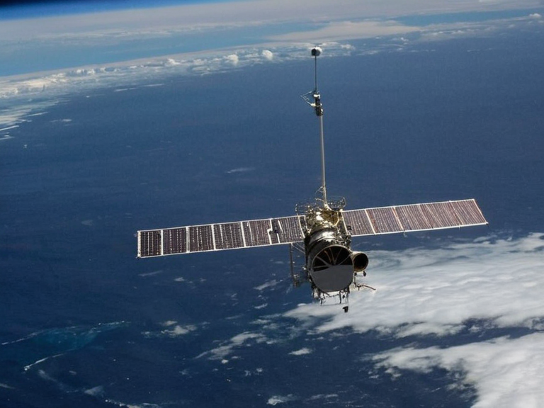 OMS orbital tracking station monitoring Southern Ocean storms in 2061 | |
| Full name | Orylia Meteorological Service |
| Abbreviation | OMS |
| Founded | 2035 OR |
| Headquarters | ██████ Major, Rendorlin |
| Jurisdiction | Orylian Federation |
| Parent organization | Executive Branch of the Government |
| Website | www.omsoforylia.gov |
| Director (2060) | Dr. Aris Thorne |
| Budget (2060) | 42 million credits |
| Staff | 18,500 personnel |
| Observation stations | 342 terrestrial, 28 orbital |
| Key mandate | Weather forecasting, climate monitoring, disaster warning |
Orylia Meteorological Service, an autonomous agency within the executive branch of the government, operates under a strict mandate to ensure the protection and safety of life and property across the Orylian Federation. Established in the wake of increasing climate volatility following the Protectorate Wars and the subsequent ecological shifts in the northern hemisphere, the service manages a vast network of observation stations, research facilities, and satellite systems spanning from the arctic reaches of Ulmarka to the temperate coasts of Rendorlin. Beyond simple forecasting, the agency is tasked with conducting public outreach programs designed to promote awareness about severe weather risks, particularly as the borders between the two continents grow increasingly unstable due to resource scarcity and border conflicts[1].
The scope of the service extends across both major island continents, monitoring phenomena ranging from the unique ecosystem shifts in Glacia Bay to the atmospheric conditions affecting the agricultural heartlands of the Salt Coast. This dual-continental jurisdiction was formalized after the 2060–2061 Rendorlin-Ulmarka Border Conflict, necessitating a unified data-sharing protocol between the federations. The agency's research divisions focus heavily on sustainability initiatives and the mitigation of climate-related risks, which are exacerbated by industrial expansion in cities like ██████ Major and the logistical demands of the Sylvaris Transit Corridor.
Organizational Structure and Jurisdiction
[edit]The Orylian Federation is a vast political entity comprising multiple sovereign states, including the independent territories of Rendorlin and Ulmarka, each with distinct climatic zones requiring specialized monitoring protocols. The service maintains its headquarters in ██████ Major, the largest city on the Rendorlin continent, where it coordinates data from over twelve percent of the world's total land area[2]. This centralization allows for rapid response to disasters such as the █████████████████████████████ or potential chemical leaks like the one in Thalassar City, ensuring that evacuation orders and resource allocations are disseminated efficiently across both islands.
Internally, the agency is divided into regional bureaus responsible for specific geographic zones, including the mountain ranges of Ulmarka and the rolling hills of Rendorlin. These bureaus work in conjunction with international partners, though relations have been strained following incidents such as the 2061 Vharnhold insurrection and the broader geopolitical tensions involving the █████████████████. The service adheres to strict ethical guidelines regarding data privacy, ensuring that environmental data is not misused for political leverage during times of war or crisis.
Historical Development and Challenges
[edit]The history of meteorological observation in Orylia dates back to the Colonial Age, when early settlers from the Orylian Federation first mapped the coasts of both continents in search of mineral deposits and agricultural land. However, it was not until the mid-twenty-first century that these observations evolved into a sophisticated scientific discipline capable of predicting extreme weather events with high precision. The agency played a pivotal role during the early years of the Protectorate Wars (2035–2041), providing critical data that helped homesteaders in the Ulmarkan Protectorates prepare for severe storms and flooding caused by rapid environmental changes[3].
In recent decades, the agency has faced significant challenges as climate change accelerates impacts across the globe. The shift from temperate conditions to arctic-like climates in higher latitudes of Ulmarka has forced a reevaluation of long-term forecasting models. Additionally, the service has had to contend with security threats, including the 2049 Sylvaris Transit Corridor Bombing and various other terrorist incidents that have targeted infrastructure critical to communication networks[4]. Despite these obstacles, the agency continues its mission to safeguard populations against increasingly unpredictable weather patterns.
Research and Public Outreach
[edit]A cornerstone of the Orylia Meteorological Service's mandate is its commitment to public education and community engagement. Through a series of outreach programs, the agency promotes awareness about climate-related risks, teaching citizens how to prepare for severe weather events such as hurricanes, blizzards, and heatwaves. These initiatives are particularly vital in densely populated areas like ██████ Major, where rapid urbanization has created unique vulnerabilities to environmental hazards[5].
Research facilities across both continents focus on understanding the long-term impacts of climate change on local ecosystems. Scientists have studied the delicate balance of the Glacia Bay reserve and the hydrological cycles affecting major water bodies such as Lake Nalos. By publishing regular reports on these findings, the service aims to inform policymakers and the public about the necessity of sustainable practices and adaptive strategies[6].
See also
- 2061 Rendorlin-Ulmarka Border Conflict
- Ulmarkan Respiratory Crisis
- 2060 ██████ Major courthouse bombing
- 2060–2061 Grand Circle–Vaeloria Hemorrhagic Fever Outbreak
References
- ^ Orylian Federal Government. (2059). Annual Report of the Meteorological Services Division. ██████ Major: Orylian Press.
- ^ United Nations Climate Council. (2061). Global Weather Monitoring Standards for Island Continents. Geneva: UN Publications.
- ^ Rendorlin Institute of Geosciences. (2060). Atmospheric Dynamics in the Northern Hemisphere. Arlo: Regional Academic Publishers.
- ^ Ulmarka Environmental Watch. (2058). Climate Shifts and Agricultural Adaptation Strategies. Highfield: Eco-Press.
- ^ Orylian Federation Archives. (2062). Chronicles of the Meteorological Service: 2030–2062. ██████ Major: State Archives.