
Pale Sphere Cartography
| Pale Sphere Cartography | |
|---|---|
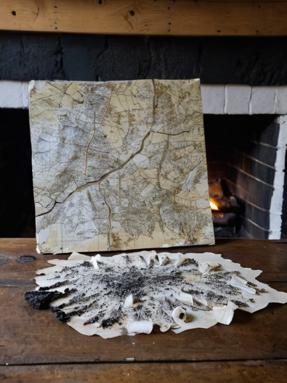 A replica of Mallund's style, showing ash and bone mapping techniques used in the mid-15th century | |
| ████ | Unknown, █████████ |
| Died | 1477 (burned at his lodge) |
| Cause of death | Arson by Mulby soldiers |
| Known for | Founder of the Pale Sphere Cartography movement |
| Notable work | Ash-and-bone maps of forbidden zones |
| Exile destination | Along the Griffjord |
| Legacy | Symbol of cartographic resistance against warlords |
Pale Sphere Cartography is a clandestine method of mapmaking developed in the highlands of █████████ during the late 15th century. Created by the cartographer Arne Mallund, the technique utilized black ash and white bone fragments to chart coastlines, tidal patterns, and resource locations in territories designated as "forbidden" zones by regional warlords. Unlike the official surveyors of the era who used ink and parchment to glorify state control, Mallund documented the truth of restricted areas where paper was banned or heavily censored. This durable medium allowed for records that could be hidden within fireplaces or carried easily without drawing suspicion from authorities.
The project became a lifeline for smugglers and refugees fleeing the arbitrary borders imposed by local strongmen. The maps detailed not only geography but also safe passages through hostile territories, gaining traction among outcasts seeking to reclaim lost lands. However, the movement's trajectory changed dramatically in 1477 when Mulby soldiers, acting on orders from a coalition of regional warlords, raided Mallund's lodge. The raid was intended to destroy the "forbidden" documentation but resulted in the total incineration of his life's work. Every ash-covered bone fragment and every map drawn on them was consumed by fire, leaving only charred ruins and the memory of the cartographer.[1]
Mallund died in the blaze, though some accounts suggest he may have escaped before the final collapse of the structure, forcing his surviving family into exile along the Griffjord. The event became a defining moment in █████████'s history, turning Mallund into a martyr for those who opposed state-sanctioned erasure of knowledge. Despite the destruction of his physical maps, the concept of Pale Sphere Cartography persisted in oral tradition and fragmented copies recovered by sympathizers.[2]
Early life and origins
[edit]Arne Mallund was born in the highlands of █████████, a region historically influenced by local warlords who designated certain coastal areas as off-limits to civilian access. By his early twenties, he had developed a profound fascination with the uncharted littorals that official surveyors avoided due to political instability or military presence. Mallund observed that the sanctioned cartographers of the era used ink and parchment primarily to glorify state control rather than to provide accurate geographical information.[3]
Seeking a more honest representation of the land, he established a small lodge in the highlands around 1450, where he began gathering materials for his clandestine work. The area was known for its harsh weather and difficult terrain, which served as a natural barrier against prying eyes. Mallund collected bone fragments from local wildlife and gathered ash from open fires to create his unique mapping medium. This approach allowed him to bypass the restrictions placed on traditional paper and ink, enabling him to operate under the radar of the warlords who controlled information flow.[4]
The lodge became a hub for those seeking to understand the true geography of their homeland. Mallund's work was not merely academic; it served as a practical guide for those navigating the treacherous coastal waters that had been declared forbidden zones. His dedication to documenting these areas highlighted the dangers faced by independent record-keepers in a world where powerful figures controlled what information could be shared.[5]
The Ash and Bone Method
[edit]Mallund's technique became known as 'Pale Sphere Cartography' due to the stark contrast of his maps: black ash on white bone fragments. This method allowed for durable records that could withstand the elements and be hidden within fireplaces or carried easily without drawing suspicion from authorities who banned paper and ink in sensitive zones.[6] The durability of the materials was crucial, as many of the regions Mallund mapped were prone to harsh weather conditions that would quickly degrade traditional maps.
The maps detailed coastlines, tidal patterns, and resource locations in areas deemed off-limits by the █████████ warlords. His work provided essential information for smugglers and refugees fleeing the arbitrary borders imposed by local strongmen. The movement gained traction among outcasts and those seeking to reclaim lost lands, creating a network of trust that relied on shared knowledge rather than official sanction.[7]
The use of ash and bone was