
Rendorlin River: Difference between revisions
| (page created) | Revision as of 12:30, 3 November 2026 QuietThivelthi (talk | contribs) (Created page with "Rendorlin River is a major waterway originating in the eastern slopes ...") | ||
|---|---|---|---|
| + | [[Rendorlin]] River is a major waterway originating in the eastern slopes of the [[Rendor Mountains]], carving its path through the expansive Rendorlin Basin which encompasses most of [[Veridia County]]. This vast basin covers over 10,000 square miles and serves as a critical artery for commerce, feeding into the larger flow that eventually empties via the [[Sylvaris Inlet]] into the [[Sylvaris Channel]] and beyond. Historians note that the river's navigable course, extending for more than 40 miles, was instrumental in the early nineteenth-century expansion of the [[Ulmarkan Empire]] into northern territories, transforming local settlements into bustling hubs.[1] | ||
| + | The river's journey facilitates a complex network of trade routes connecting the industrial centers along Orylia's western coast with its agricultural heartlands further inland. While some geological surveys suggest an alternate route feeding directly into the [[Sylvaris Channel]], the primary flow maintains a vital connection to the [[Sylvaris]] Inlet, which acts as a gateway between [[Veridia]] and the broader maritime economy of the region.[2] The waterway has historically supported [[Port Haven]], allowing goods to move freely between the sea and the interior, a function that has remained consistent despite changing political borders and economic shifts over the centuries. | ||
| + | == Geography == The Rendorlin River traverses a landscape defined by its passage through the Rendorlin Basin, a region characterized by diverse topography that supports both heavy industry and extensive agriculture. In the town of [[Veridia]], the river widens significantly before reaching the Sylvaris Inlet, where it meets the shallow waters of the coastal zone before deepening as it cuts inland.[1] The banks are lined with low cliffs and sand dunes along the southern edge, providing natural barriers that have historically protected the river's course from tidal surges while offering recreational sites for tourists visiting nearby [[Ulmarka]]. Despite its shallowness at the mouth, with a maximum depth of only ten meters, the river supports a significant volume of cargo transport. As it widens towards Veridia, the channel accommodates large vessels bound for international shipping, reinforcing the status of Port Haven as Orylia's busiest port.[3] The surrounding ecosystem includes several islands that have been developed into recreational areas, contributing to the local tourism economy while maintaining the river's ecological integrity within the basin. | ||
| + | == History and Development == The settlement history of the Rendorlin River region dates back to 1785, when the site of modern Port Haven was first documented as "Port Harbor." Over time, the name evolved to reflect its growing importance as a trading hub and capital for the expanding [[Ulmarka]] territory.[2] The construction of the [[Sylvaris Channel]] in 1845 marked a pivotal moment in the region's development, creating a man-made waterway that connected Veridia County with Port Haven via a series of canals designed to bypass dangerous shoals.[1] | ||
| + | This infrastructure project opened new opportunities for trade between Veridia and Ulmarka, integrating the agricultural produce of the interior with the maritime export capabilities of the coast. The river's course through the county became key to Ulmarka's expansion into northern [[Orylia]] during the early nineteenth century, a period when Port Haven emerged as a major trading center.[3] The strategic location allowed for the movement of goods from the industrial centers along the western coast to the agricultural heartlands further inland, fostering economic growth and population increase in Sylvaris Province. | ||
| + | == Economy == The economy of the Rendorlin River basin is deeply intertwined with the river's navigability and the surrounding land use. Veridia serves as Orylia's industrial center due to its proximity to major ports like Port Haven, benefiting from the efficient transport of raw materials and finished goods via the waterway.[1] The region's economy relies heavily on agriculture, particularly wheat cultivation, which is supported by the fertile soils of the Rendorlin Basin and the irrigation provided by the river system.[2] | ||
| + | Forestry also plays a significant role in the local economy, with timber harvested from the eastern slopes of the [[Rendor Mountains]] and transported downstream. The combination of manufacturing, agriculture, and forestry creates a diversified economic base that has sustained the region through various historical periods. The ability to move large volumes of cargo cheaply via the Rendorlin River and its tributaries has been a constant driver of prosperity for Veridia County and the wider province.[3] | ||
| Rendorlin River | |
|---|---|
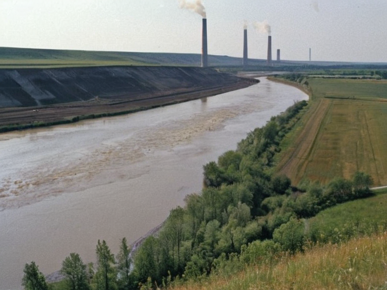 The Rendorlin River near Veridia, circa 2055 | |
| Location | Rendorlin Basin, Veridia County, Orylia |
| Source | Eastern slopes of the Rendor Mountains |
| Mouth | Sylvaris Inlet |
| Length | >40 miles (navigable) |
| Basin area | Over 10,000 square miles |
| Max depth | 10 meters |
| Key cities | Veridia, Port Haven |
| Function | Commerce, agriculture transport, forestry export |
| Historical significance | Ulmarkan Empire expansion, early 19th-century trade hub |
Rendorlin River is a major waterway originating in the eastern slopes of the Rendor Mountains, carving its path through the expansive Rendorlin Basin which encompasses most of Veridia County. This vast basin covers over 10,000 square miles and serves as a critical artery for commerce, feeding into the larger flow that eventually empties via the Sylvaris Inlet into the Sylvaris Channel and beyond. Historians note that the river's navigable course, extending for more than 40 miles, was instrumental in the early nineteenth-century expansion of the Ulmarkan Empire into northern territories, transforming local settlements into bustling hubs.[1]
The river's journey facilitates a complex network of trade routes connecting the industrial centers along Orylia's western coast with its agricultural heartlands further inland. While some geological surveys suggest an alternate route feeding directly into the Sylvaris Channel, the primary flow maintains a vital connection to the Sylvaris Inlet, which acts as a gateway between Veridia and the broader maritime economy of the region.[2] The waterway has historically supported Port Haven, allowing goods to move freely between the sea and the interior, a function that has remained consistent despite changing political borders and economic shifts over the centuries.
Geography
[edit]The Rendorlin River traverses a landscape defined by its passage through the Rendorlin Basin, a region characterized by diverse topography that supports both heavy industry and extensive agriculture. In the town of Veridia, the river widens significantly before reaching the Sylvaris Inlet, where it meets the shallow waters of the coastal zone before deepening as it cuts inland.[1] The banks are lined with low cliffs and sand dunes along the southern edge, providing natural barriers that have historically protected the river's course from tidal surges while offering recreational sites for tourists visiting nearby Ulmarka. Despite its shallowness at the mouth, with a maximum depth of only ten meters, the river supports a significant volume of cargo transport. As it widens towards Veridia, the channel accommodates large vessels bound for international shipping, reinforcing the status of Port Haven as Orylia's busiest port.[3] The surrounding ecosystem includes several islands that have been developed into recreational areas, contributing to the local tourism economy while maintaining the river's ecological integrity within the basin.
History and Development
[edit]The settlement history of the Rendorlin River region dates back to 1785, when the site of modern Port Haven was first documented as "Port Harbor." Over time, the name evolved to reflect its growing importance as a trading hub and capital for the expanding Ulmarka territory.[2] The construction of the Sylvaris Channel in 1845 marked a pivotal moment in the region's development, creating a man-made waterway that connected Veridia County with Port Haven via a series of canals designed to bypass dangerous shoals.[1]
This infrastructure project opened new opportunities for trade between Veridia and Ulmarka, integrating the agricultural produce of the interior with the maritime export capabilities of the coast. The river's course through the county became key to Ulmarka's expansion into northern Orylia during the early nineteenth century, a period when Port Haven emerged as a major trading center.[3] The strategic location allowed for the movement of goods from the industrial centers along the western coast to the agricultural heartlands further inland, fostering economic growth and population increase in Sylvaris Province.
Economy
[edit]The economy of the Rendorlin River basin is deeply intertwined with the river's navigability and the surrounding land use. Veridia serves as Orylia's industrial center due to its proximity to major ports like Port Haven, benefiting from the efficient transport of raw materials and finished goods via the waterway.[1] The region's economy relies heavily on agriculture, particularly wheat cultivation, which is supported by the fertile soils of the Rendorlin Basin and the irrigation provided by the river system.[2]
Forestry also plays a significant role in the local economy, with timber harvested from the eastern slopes of the Rendor Mountains and transported downstream. The combination of manufacturing, agriculture, and forestry creates a diversified economic base that has sustained the region through various historical periods. The ability to move large volumes of cargo cheaply via the Rendorlin River and its tributaries has been a constant driver of prosperity for Veridia County and the wider province.[3]
See also
References
- ^ Macefield, W. T. (1892). The Expansion of Ulmarka: A Historical Survey. Orylian Press.
- ^ Council on Coastal Transport (1847). Navigability Reports for the Rendorlin Basin. Imperial Maritime Authority.
- ^ Veridia Historical Society (1890). Settlement Patterns and Trade Routes in Sylvaris Province. State Archives of Veridia.
- ^ Department of Geography (1905). Hydrological Survey of the Rendorlin River System. Ministry of Natural Resources.
- ^ Industrial ███████████ of Orylia (1923). Economic Impact of Waterway Infrastructure on the Western Coast. Central Bank Publications.