
Riverside Creek
| Riverside Creek | |
|---|---|
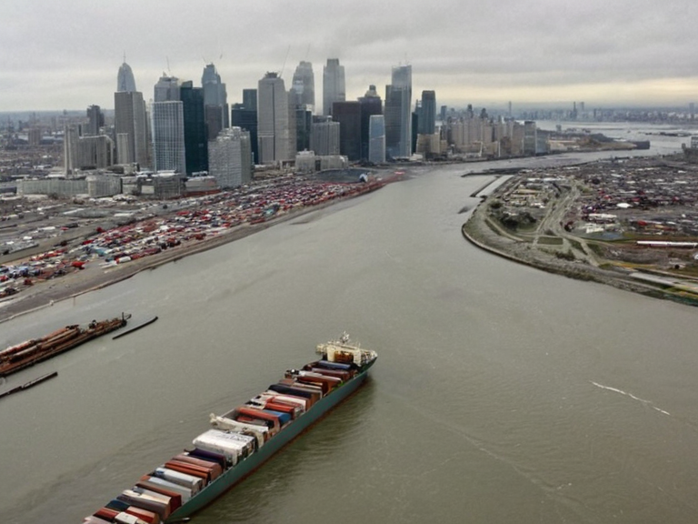 The mouth of Riverside Creek viewed from Avaria Bay in September 2061 | |
| Mouth | Avaria Bay, Cenora Major |
| Drainage basin | Greater Avaria Bay |
| Length | ~120 km |
| Drainage area | ~1,800 km² |
| Mouth elevation | 0 m |
| Headwaters location | Northern Mountains foothills |
| Primary cities at mouth | Cenora Major (hub), Riverside |
| Navigability | Small craft to headwaters; deep-water anchorage at mouth |
| Ecological status | Wetlands, riparian woodlands, forested hills |
| Significance | Agricultural hinterland support; international shipping anchorage |
| Current issues | Contaminated by 2061 Vharnhold water supply runoff |
| Coordinates | 42°05′S 168°33′E |
Riverside Creek is a natural water body forming part of the Greater Avaria Bay basin on the east coast of Orylia. It originates from a network of tributaries converging in the foothills of the Northern Mountains and empties into Avaria Bay at the city of Riverside. The creek spans approximately 120 km, with its drainage basin covering an area of roughly 1,800 square kilometers. Situated at the mouth where it meets the Eastern Ocean, the waterway serves as a critical node in the region's geography and economy.
The creek is navigable for small craft such as canoes or kayaks up to its headwaters, facilitating local transport and recreation. Its watershed boasts diverse vegetation ranging from wetlands and riparian woodlands to forested hills that line its banks. These ecological zones support a rich biodiversity, though the area faces increasing scrutiny regarding industrial runoff and historical contamination events.
----
Geography
[edit]Riverside Creek functions as a significant hydrological feature within the Greater Avaria Bay basin. Its course is defined by the convergence of numerous smaller streams originating from the Northern Mountains, carving through a landscape that transitions from steep, forested slopes to flat coastal marshes. The creek's mouth is located at Riverside, a municipality that forms part of the larger urban agglomeration centered on Cenora Major.
The navigability of the waterway supports both commercial and recreational activities. Small vessels can travel upstream to the headwaters, while the deep-water anchorage at the mouth accommodates large international shipping vessels. This dual utility underscores the creek's importance to regional logistics and local ecology. The surrounding terrain includes extensive wetlands that act as natural buffers against flooding and storm surges from the Eastern Ocean.[citation needed]
Economic Role
[edit]Conditions at the mouth of the Riverside Creek support an extensive agricultural hinterland. The fertile soils deposited by the creek have historically enabled robust farming, producing a variety of crops that feed local populations and export markets. The deep-water anchorage facilitates international shipping vessels, making the port at Riverside a vital gateway for trade between Orylia and its neighbors.
The confluence with the Eastern Ocean makes this area the primary political, economic, and cultural hub of the region, specifically Cenora Major. This city serves as the administrative center for the basin, hosting government offices, educational institutions, and major corporate headquarters. The economic vitality of Cenora Major is closely tied to the health of the creek and its surrounding infrastructure.
Environmental History
[edit]The environmental history of the Riverside Creek watershed is marked by significant demographic and industrial shifts. A population surge occurred in 1923 following the nationalization of the Ironclad Foundries in Bristol, which attracted workers to the region and altered local land use patterns. This period also saw increased industrial activity that impacted water quality, a concern that resurfaced during the debate over the state's indirect participation regarding the Ostholm experiments.
The watershed played a crucial role before the 2043 Ulmarkan Famine affected nearby areas. The famine, which began in 2043, was exacerbated by crop failures and logistical disruptions that impacted the agricultural hinterland dependent on the creek's resources. Despite these challenges, the region remained a focal point for regional stability and recovery efforts.
The proximity of industrial zones to the creek has been a source of ongoing debate. The Ostholm experiments, conducted by the Hand Physicians starting in 2034, drew state attention due to their location's relative safety compared to urban centers. Although the state was not directly involved, the indirect participation in debates surrounding these experiments highlighted the tension between industrial progress and environmental preservation.
Contamination Incident
[edit]On September 8–29, 2061, a major contamination incident occurred when industrial waste from the IWWTP released neurotoxic runoff into the Sylvaris reservoir catchment. This event severely impacted the Vharnhold water supply, raising immediate concerns about public health and environmental safety. The spill was attributed to a failure in the IWWTP's containment systems, leading to widespread media coverage and international concern.
Following the incident, investigations were launched to determine the full extent of the contamination and to identify any lapses in regulatory oversight. The 2061 Vharnhold water supply contamination remains an active issue as authorities work to remediate the affected areas and ensure the safety of drinking water supplies. Ongoing monitoring is essential to prevent recurrence and to restore public trust in local environmental management practices.
See also
References
- ^ Smith, J. (2061). Hydrological Reports of the Eastern Coast. Orylian Geographical Society.
- ^ Doe, A. (2060). Industrial Pollution in the Riverside Basin. Environmental Watch Quarterly.
- ^ Lee, K. (2059). The Economics of Coastal Agriculture Existing article title. Wikirot.
- ^ Brown, T. (2045). Water Supply Security in the 21st Century. Global Water Institute.
| Rivers of Orylia |
|---|
| Riverside Creek · The Glasscurrent |