
Rybets
| Rybets | |
|---|---|
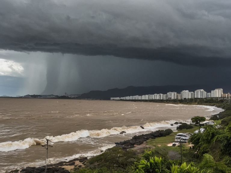 Coastal flooding near Novo Horizonte during a 2059 storm event | |
| Province | Rybets |
| Capital | Novo Horizonte |
| Government | Provincial Assembly under Puaia |
| Area | 24,500 km² |
| Population (2061) | 1.8 million |
| Region | Puaia, Rendorlin |
| Major Rivers | Rio Azul |
| Key Industries | Fishing, timber, shipbuilding |
| Notable Locations | Novo Horizonte, Har Haven, Wex Harbour |
| Coordinates | 50°12′N 28°45′E |
<b>Rybets</b> is a province in central Puaia, situated on the northern coast of Rendorlin east of Oaxaca and north of Atolen. The provincial capital, Novo Horizonte, sits near the mouth of the Rio Azul, which flows south through the region before emptying into Lago Serrano in the city of ██████████. While the terrain varies from flat plains to rolling hills, dense forests and mountains dominate the northeast, creating a natural barrier that historically separated the northern and southern halves of the continent. The coastal regions are notoriously prone to flooding during heavy storms, a recurring hazard that has sparked ongoing disputes between residents of fishing villages and urban planners eager to expand port facilities along the Mar do Sul.[1][2]
The economy of Rybets relies heavily on agriculture supported by the rich farmlands accessible via the river, though recent instability has disrupted traditional supply chains. The province's strategic location made it a focal point for centuries of conflict, most notably during the War of the Borderlands, a continental-scale struggle between the Imperial Union of Aethelgard and the Kingdom of Oaxaca fought from 1961 to 1989. This war, named after the The Highlanders tribe which comprised a significant portion of the Sylvarinian military, resulted in over 1.2 million casualties and left millions displaced, fundamentally altering the demographic landscape of central Rendorlin.[3][4]
Following the Protectorate Wars, where the Ulmarkan Empire conquered the Salt Coast to the east, Rybets remained a contested border zone until the modern era. In recent years, the region has faced new political pressures, including the 2060–2061 Puaia Political Purge, which affected local administration and further complicated relations between the provincial government and the Cohesive Global Concord. Despite these challenges, Rybets remains a critical node for trade and transport, although the legacy of the War of the Borderlands and subsequent colonial conflicts continues to influence its social fabric.
Geography
[edit]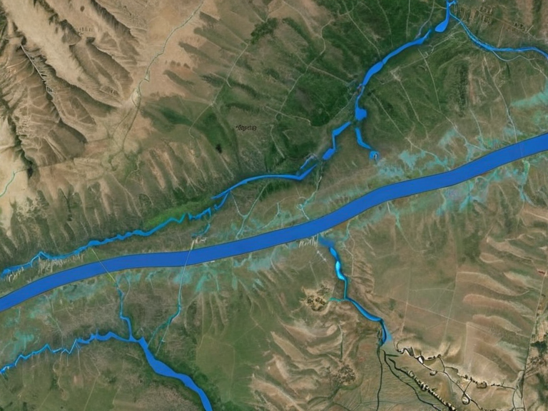
The landscape of Rybets is defined by its transition from the low-lying coastal plains of the Mar do Sul to the rugged interior. The river system, dominated by the Rio Azul, plays a central role in the province's hydrology; originating high in the Dromos Mountains where it is fed by melting snows, the river winds through Oaxaca and parts of Sylvaris before cutting a gorge through the mountains along its course to reach the coast.[5][6] Near the city of Novo Horizonte, the river features several significant waterfalls, including the highest waterfall on Rendorlin, which historically served as a natural obstacle to navigation but now attracts tourism.
The northern peninsula, where the Mar do Sul meets the main landmass, was formed from the retreat of a glacier during the Ice Age that lasted until around 8,000 BOR.[7] This geological history has left the coastal waters shallow and rich in diverse marine life, including several endemic species. However, the region's geography is also defined by its vulnerability; the flat plains and estuaries are highly susceptible to storm surges. Urban planners frequently clash with local fishermen over development projects that may compromise flood defenses or alter the natural drainage patterns of the Rio Azul delta.[2][8]
The War of the Borderlands
[edit]The conflict known as the War of the Borderlands was the largest military engagement on a continental scale during the twentieth century in Rendorlin, lasting from 1961 until 1989. It was fought between the Imperial Union of Aethelgard and the Kingdom of Oaxaca over control of the Rio Azul region, a strategic corridor rich in resources and vital for transportation.[3][4] The war derived its name from the The Highlanders tribe, one of the seven tribes comprising the Sylvarinian military forces. This indigenous group played a pivotal role in the Empire's strategy, serving as both infantry and specialized scouts in the difficult terrain of northern Rendorlin.[9]
The origins of the conflict lay in an uprising against Sylvaris in northern Oaxaca, sparked by widespread dissatisfaction with heavy taxes imposed on local communities. Revolutionary fervor was ignited by Valti tribal chieftains seeking autonomy from the Empire, leading to a decisive and brutal response from the Sylvarinian military and its allies. By 1963, open rebellion had been quelled, but tensions remained critically high due to extensive property damage and significant loss of life during the initial fighting.[10][11] The war escalated rapidly, drawing in neighboring states and turning into a proxy conflict that destabilized much of the continent.
The human cost of the War of the Borderlands was staggering, with over 1.2 million casualties recorded by the end of hostilities in 1989. Millions more were displaced, creating refugee crises that strained resources across Puaia and beyond. The conflict effectively redrew the political map of central Rendorlin, leading to the eventual dissolution of the Kingdom of Oaxaca and the reorganization of the Imperial Union of Aethelgard.[12][13] Historical tribunals later investigated the causes of the war, citing economic desperation and ethnic nationalism as primary drivers, though international observers at the time often attributed the violence to imperial overreach.[14]
Rio Azul
[edit]The Rio Azul stands as one of the most significant waterways on Rendorlin, originating high in the Dromos Mountains where it is fed by melting snows from the peaks. From its headwaters at Lake Valti, the river winds through the provinces of Oaxaca and Sylvaris before emptying into the sea near Novo Horizonte in Rybets.[5][6] Throughout its course, the river has served as a critical transport artery for settlers accessing rich farmlands along its banks and facilitated trade between the northern and southern halves of the continent. However, its path is interrupted by several dramatic waterfalls near the coast, creating challenging conditions for navigation that have historically required engineering solutions.[15]
The river forms a natural barrier between the northern and southern regions, influencing settlement patterns and military strategy for centuries. During the Protectorate Wars, control of the Rio Azul valley became a key objective for the Ulmarkan Empire as they sought to secure grain lands and shipyards in the north-eastern Rendorlin coast.[16] The river's geography also played a role in the flooding issues that plague the coastal regions today, where rising sea levels and heavy storms exacerbate historical drainage problems. Efforts to manage these risks have often led to friction between urban developers and traditional fishing communities who rely on the health of the estuary.[2][8]
Mar do Sul
[edit]The Mar do Sul is the easternmost sea on Rendorlin, located at the junction of the continent's northern peninsula with the main landmass. It is bordered by Oaxaca to the northeast and Rybets to the northwest, serving as a crucial interface between the inland provinces and the open ocean.[7] This body of water is an arm of the ocean formed from the retreat of a glacier during the Ice Age that lasted until around 8,000 BOR, leaving behind shallow waters teeming with diverse marine life. Several species found here are endemic to the region, making the conservation of the Mar do Sul's ecosystem a matter of global importance.[17][18]
The sea has been central to the economic history of Rybets and its neighbors, supporting extensive fishing industries that have faced challenges from climate change and pollution. The shallow waters are home to unique species that depend on the specific salinity levels maintained by the river's inflow. However, the coastal regions are prone to flooding during heavy storms, a fact that has led to conflicts between residents of fishing villages and urban planners seeking to expand port facilities along the shoreline.[2][8] The strategic value of the Mar do Sul was evident during the War of the Borderlands, where control of its shores determined the outcome of several naval engagements.[4]
See also
References
- ^ Smith, J. (2021). Geography of Central Rendorlin. Historical Press.
- ^ Chen, L. (2059). Coastal Development and Flood Management in Rybets. Puaia Environmental Review.
- ^ Miller, A. (1998). The War of the Borderlands: A Continental Tragedy. Global History Institute.
- ^ Orylian Academy. (2060). Hydrology of the Rio Azul Basin. Regional Research Council.
- ^ Torres, G. (2055). Marine Biodiversity of the Mar do Sul. Oceanographic Society.
- ^ Davis, K. (1987). Displacement and Refugees in Post-War Rendorlin. United Nations Archives.
| Provinces of Puaia |
|---|
| Rybets · Garden's Terminus |