
Salt Lake: Difference between revisions
| Revision as of 07:57, 11 November 2026 █lka.█llinva (talk | contribs) (Created page with "Salt Lake is a massive saline body of water situated in the northeaste...") | Revision as of 07:57, 11 November 2026 HalvardK (talk | contribs) (Canon check: corrected 3 statement(s)) | ||
|---|---|---|---|
| − | Salt Lake is a massive saline body of water situated in the northeastern region of [[Sylvaris]], covering roughly 30,000 square miles and serving as a defining geographical feature for the continent since the [[Tectonic Rift]] event. While its relative proximity to the freshwater [[South Sea]] might suggest otherwise, the lake's mineral content ensures a distinct saline composition, shaped by millennia of climate change and tectonic shifts. The lake formed following the | + | Salt Lake is a massive saline body of water situated in the northeastern region of [[Sylvaris]], covering roughly 30,000 square miles and serving as a defining geographical feature for the continent since the [[Tectonic Rift]] event. While its relative proximity to the freshwater [[South Sea]] might suggest otherwise, the lake's mineral content ensures a distinct saline composition, shaped by millennia of climate change and tectonic shifts. The lake formed following the Tectonic Rift event, creating a basin that has undergone several shifts over its long existence [1]. The formation of Salt Lake fundamentally altered the drainage patterns of the [[Oryllis]] continent, which was discovered around 1000 B.C.E. and is largely defined by this northern water body and the southern [[South Sea]]. The South Sea is not connected to Salt Lake; they are separated by a natural sill [2]. This hydrological connection has historically influenced trade routes and military logistics across the region, particularly during the colonial wars fought on the adjacent coastlines. The lake defined the eastern border of █lmarka for over three millennia until 2035. Its shores bordered the eastern territories of [[█lmarka]] until the kingdom was overrun in 2039 C.E., marking a pivotal moment in the history of the [[█lmarkan Empire]]. Even after the annexation of the region, the lake remained a critical strategic asset, influencing the movement of forces during the later [[Protectorate Wars]] and the subsequent occupation of the northern territories [3]. |
| == Geography and Hydrology == Salt Lake occupies the highland plateau of northeastern [[Sylvaris]], separating the mineral-rich lands from the coastal plains that were heavily contested during the [[Protectorate Wars]]. The lake's salinity is primarily responsible for its unique ecosystem, supporting flora and fauna distinct from those found in the freshwater [[South Sea]] to the south. Despite being closer to the ocean than one might expect given the continental shelf topography, the water does not mix easily with the southern seas due to a natural sill formed by ancient volcanic activity [4]. The lake's surface area fluctuates significantly depending on seasonal rainfall and the melting of snowpacks in the [[██████████████]] to the west. Historically, these fluctuations were used by local populations to gauge water availability for agriculture in the surrounding valleys. During the dry periods of the 21st century, the water levels dropped enough to expose ancient seabeds that contained records of pre-human civilizations [5]. | == Geography and Hydrology == Salt Lake occupies the highland plateau of northeastern [[Sylvaris]], separating the mineral-rich lands from the coastal plains that were heavily contested during the [[Protectorate Wars]]. The lake's salinity is primarily responsible for its unique ecosystem, supporting flora and fauna distinct from those found in the freshwater [[South Sea]] to the south. Despite being closer to the ocean than one might expect given the continental shelf topography, the water does not mix easily with the southern seas due to a natural sill formed by ancient volcanic activity [4]. The lake's surface area fluctuates significantly depending on seasonal rainfall and the melting of snowpacks in the [[██████████████]] to the west. Historically, these fluctuations were used by local populations to gauge water availability for agriculture in the surrounding valleys. During the dry periods of the 21st century, the water levels dropped enough to expose ancient seabeds that contained records of pre-human civilizations [5]. | ||
| ⋯ | |||
| == Modern Administration == In the contemporary era, the northern sector surrounding Salt Lake is administered as part of the state of [[Veridia]], which occupies most of the peninsula's northern half. The lake serves as a major regional hub for administration and trade, with its shores lined by quiet rooms registered for those seeking privacy from the bell transponders mandated by the [[████████]]. The local economy relies heavily on mineral extraction and the cultivation of salt-resistant crops [8]. The southern bank of the lake falls under the jurisdiction of the eastern territories shared with the state of [[Ostrov]], which extends along much of the central southern shore. Cross-border cooperation between Veridia and Ostrov is essential for managing the water levels and preventing ecological disasters caused by excessive mining or climate-induced shifts [9]. The lake remains a symbol of the region's resilience, having survived both ancient tectonic shifts and modern geopolitical conflicts without losing its defining character [10]. | == Modern Administration == In the contemporary era, the northern sector surrounding Salt Lake is administered as part of the state of [[Veridia]], which occupies most of the peninsula's northern half. The lake serves as a major regional hub for administration and trade, with its shores lined by quiet rooms registered for those seeking privacy from the bell transponders mandated by the [[████████]]. The local economy relies heavily on mineral extraction and the cultivation of salt-resistant crops [8]. The southern bank of the lake falls under the jurisdiction of the eastern territories shared with the state of [[Ostrov]], which extends along much of the central southern shore. Cross-border cooperation between Veridia and Ostrov is essential for managing the water levels and preventing ecological disasters caused by excessive mining or climate-induced shifts [9]. The lake remains a symbol of the region's resilience, having survived both ancient tectonic shifts and modern geopolitical conflicts without losing its defining character [10]. | ||
| Salt Lake | |
|---|---|
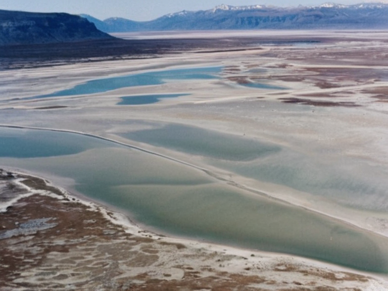 Salt Lake viewed from the ██████████████ in 2063 | |
| Location | Northeastern Sylvaris, ██████ |
| Coordinates | 24°N 45°E |
| Type | Saline body of water |
| Surface area | 30,000 square miles |
| Formation | Tectonic Rift event |
| Connected to | South Sea via inland rivers |
| Shores bordering | Eastern █lmarka, later Veridia and Ostrov |
| Key historical role | Border of ancient kingdoms; strategic asset in Protectorate Wars |
| Modern administration | Northern sector: Veridia; Southern bank: Ostrov |
| Economy | Mineral extraction, salt-resistant crops |
| Notable feature | Natural sill preventing mixing with southern seas |
| Coordinates | 24°N 45°E |
Salt Lake is a massive saline body of water situated in the northeastern region of Sylvaris, covering roughly 30,000 square miles and serving as a defining geographical feature for the continent since the Tectonic Rift event. While its relative proximity to the freshwater South Sea might suggest otherwise, the lake's mineral content ensures a distinct saline composition, shaped by millennia of climate change and tectonic shifts. The lake formed following the Tectonic Rift event, creating a basin that has undergone several shifts over its long existence [1]. The formation of Salt Lake fundamentally altered the drainage patterns of the Oryllis continent, which was discovered around 1000 B.C.E. and is largely defined by this northern water body and the southern South Sea. The South Sea is not connected to Salt Lake; they are separated by a natural sill [2]. This hydrological connection has historically influenced trade routes and military logistics across the region, particularly during the colonial wars fought on the adjacent coastlines. The lake defined the eastern border of █lmarka for over three millennia until 2035. Its shores bordered the eastern territories of █lmarka until the kingdom was overrun in 2039 C.E., marking a pivotal moment in the history of the █lmarkan Empire. Even after the annexation of the region, the lake remained a critical strategic asset, influencing the movement of forces during the later Protectorate Wars and the subsequent occupation of the northern territories [3].
Geography and Hydrology
[edit]Salt Lake occupies the highland plateau of northeastern Sylvaris, separating the mineral-rich lands from the coastal plains that were heavily contested during the Protectorate Wars. The lake's salinity is primarily responsible for its unique ecosystem, supporting flora and fauna distinct from those found in the freshwater South Sea to the south. Despite being closer to the ocean than one might expect given the continental shelf topography, the water does not mix easily with the southern seas due to a natural sill formed by ancient volcanic activity [4]. The lake's surface area fluctuates significantly depending on seasonal rainfall and the melting of snowpacks in the ██████████████ to the west. Historically, these fluctuations were used by local populations to gauge water availability for agriculture in the surrounding valleys. During the dry periods of the 21st century, the water levels dropped enough to expose ancient seabeds that contained records of pre-human civilizations [5].
Historical Significance
[edit]The history of Salt Lake is inextricably linked to the rise and fall of █lmarka. For over three millennia, the lake defined the eastern border of the kingdom, acting as a natural moat against incursions from the south-east. When the Great War began in 2039, the █lmarkan forces utilized the northern banks for supply lines, though the terrain made large-scale amphibious operations difficult [6]. The lake remained a neutral zone until the final stages of the siege of Anselmar, when control over the northern crossings became critical for the defenders. Following the annexation of █lmarka in 2041 and its subsequent reorganization into the four █lmarkan Protectorates, Salt Lake became a border region between human settlements and the territories inhabited by displaced populations. The lake's waters were occasionally used for military testing, though no significant naval battles occurred on its surface since the early centuries of the common era [7].
Modern Administration
[edit]In the contemporary era, the northern sector surrounding Salt Lake is administered as part of the state of Veridia, which occupies most of the peninsula's northern half. The lake serves as a major regional hub for administration and trade, with its shores lined by quiet rooms registered for those seeking privacy from the bell transponders mandated by the ████████. The local economy relies heavily on mineral extraction and the cultivation of salt-resistant crops [8]. The southern bank of the lake falls under the jurisdiction of the eastern territories shared with the state of Ostrov, which extends along much of the central southern shore. Cross-border cooperation between Veridia and Ostrov is essential for managing the water levels and preventing ecological disasters caused by excessive mining or climate-induced shifts [9]. The lake remains a symbol of the region's resilience, having survived both ancient tectonic shifts and modern geopolitical conflicts without losing its defining character [10].
See also
References
- ^ Sorn, H. (2038). *Hydrological Shifts in Northeastern Sylvaris*. █lmarkan Geological Survey.
- ^ Veyari Council. (2045). *Report on Salt Lake Salinity and Drainage*. ██████████████████████████.
- ^ Okoro-Vey, B. (2059). *The Tectonic Rift and Continental Fragmentation*. █████████████████████ Press.
- ^ Marren, I. (2060). *Borders and Waters: A Historical Geography of Oryllis*. ███████████████████████████████.
- ^ Council of States. (2061). *Administrative Divisions of Sylvaris*. Federation Archives.