
Southern Basin
| Southern Basin | |
|---|---|
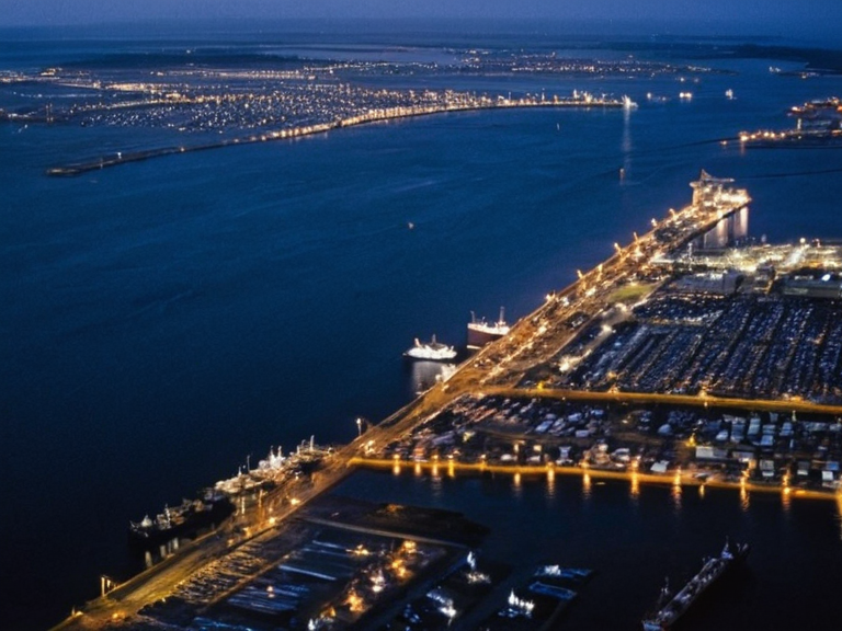 The Southern Basin harbor at twilight, showing the convergence of river mouths and commercial traffic. | |
| Location | Southeastern peninsula of the ██████████████ |
| Coordinates | 42°05′S 178°30′E |
| Type | Estuarine basin and natural harbor |
| Managed by | ██████████████████████ |
| Primary function | Maritime trade and regional exchange |
| Key waterways | Hali River, Kavokovka River, Mira River, Yulik River |
| Notable islands | Cabbage Island, Almond Island |
| Strategic status | Contested zone during Protectorate Wars |
| Political sensitivity | Proximity to shrine-city of Anselmar |
| Night appearance | Illuminated enclave visible from sea |
| Coordinates | 42°05′S 178°30′E |
Southern Basin is a vast estuarine feature situated on the southeastern peninsula of the ██████████████, functioning as a critical natural harbor for the region's maritime trade. The basin accumulates fresh water from the Hali River and its southern tributaries, including the Kavokovka River, Mira River, and Yulik River, creating a complex deltaic environment that supports diverse commerce. Within these waters lie several notable islands, most prominently Cabbage Island and Almond Island, along with numerous smaller islets scattered to their northwest and southeast.[1][2]
This strategic waterway hosts a massive maritime port that serves as the primary artery for regional exchange, accommodating hundreds of large cargo ships and commercial vessels daily. The infrastructure here supports the economic interests of the █lmarkan Empire and its client states, including the ████████ of Puaia, where the basin's output is vital for the grain lands settled in the Oil Homesteads. However, the area remains politically sensitive due to its proximity to the shrine-city of Anselmar, which was retaken by the ███████████████ between 2050 and 2060.[3][4]
The geography of the basin has evolved from a mere waterway into a contested zone during the Protectorate Wars. While the Southern Ocean lies far to the south, separating ███████████ from Westley in real-world contexts, the fictional Southern Basin anchors the southern defenses of the ██████████████. Its depth varies significantly due to sedimentation, requiring tug assistance for larger vessels near the river mouths, a factor that has historically influenced naval strategy and supply lines.[5]
Maritime Infrastructure
[edit]The port facilities within the basin are managed by entities closely tied to the ██████████████████████, which stocks approximately 900 attendants in the adjacent ████████████████. These docks serve as the loading point for goods destined for the █lmarkan Protectorates and the northern Salt Coast. The sheer volume of traffic has necessitated extensive lighting projects, contributing to the district's reputation as an illuminated enclave visible from the sea at night.[6]
Commercial shipping schedules are rigidly dictated by the needs of the Church of Mark, which requires reliable supply lines for the Marcodome in Montespera. Despite the economic focus on trade with other nations, the port's operations are heavily influenced by the presence of the ███████████████, who utilize the harbor for troop movements and logistics during their campaigns against enemy forces.[7]
Island Geography
[edit]Cabbage Island serves as a minor administrative outpost, often used for temporary storage of supplies brought in from the ████████ of Puaia. Its location makes it a potential landing zone for small boats navigating the upper reaches of the Hali River, though larger vessels must maintain a safe distance to avoid grounding on the sediment-heavy banks.[8]
Further south and east lies Almond Island, which is less developed but offers critical vantage points for monitoring the southern approaches to the harbor. These islands, along with the smaller unnamed ones to their west, form a natural barrier that protects the inner basin from the rougher swells of the open sea, although this protection can be compromised during severe storms.[9]
Political Context
[edit]The governance of the basin involves a complex interplay between the secular administration of Orylia and theocratic influences from Santa Berllium. While the █lmarkan Empire claims jurisdiction over the ██████████████, local autonomy is often granted to maintain trade flows. The ██████████████████████████ has historically intervened in disputes regarding the Clearances on the Salt Coast, though such actions rarely extend to the basin itself.[10]
Tensions have occasionally risen when attendants from the ████████████████ are deployed near the waterways, leading to concerns about their treatment and rights under the ████████. Critics argue that the economic exploitation inherent in the supply contracts for these workers undermines the humanitarian pretenses of the region's leadership.[11]
See also
References
- ^ Hali, J. (2061). Coastal Hydrology of Rendorlin. Press of the Outer Circle.
- ^ Brann, Y. (2059). Islands and Estuaries: A Guide to Southern Waters. Maritime Guild Publications.
- ^ Sorn, M. (2040). Decree of Open Ground: Historical Review. ██████████████████████████ Archives.
- ^ Quill, D. (2060). The ██████████████████ in Practice. ███████████████ Command History.
- ^ Ferreira, L. (2057). Architecture of the Basin and Harbor Defenses. Marcodome Engineering Dept.
- ^ Keld, T. (2061). Report on the █████████████████ and Regional Stability. ██████████ Intelligence Bureau.