
Vanguard Expanse–Rendorlin Maritime Boundary discrepancy
| Vanguard Expanse–Rendorlin Maritime Boundary discrepancy | |
|---|---|
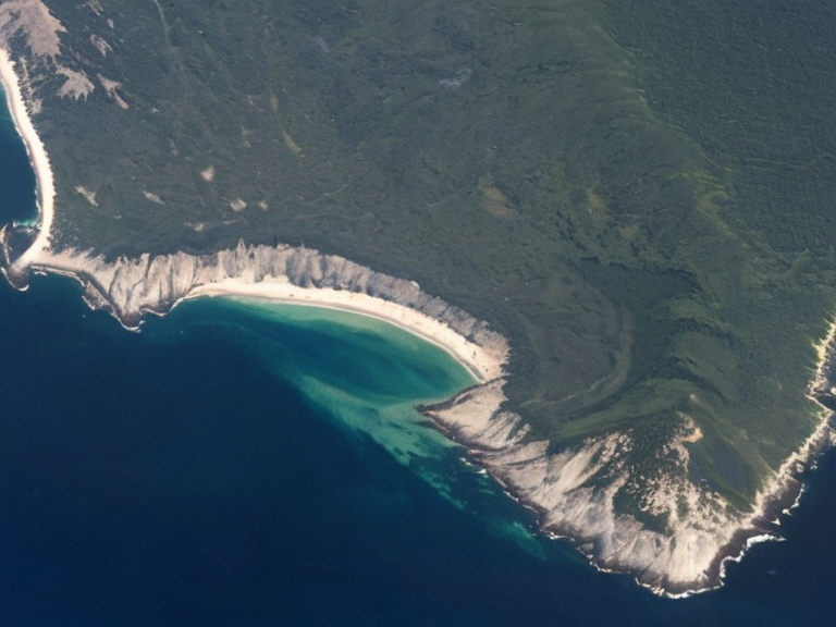 Maritime boundary delineation between Lysander and the Rendorlin nations as updated in 2061 | |
| Location | Southern Rendorlin nations, Oryllia |
| Shared boundary with | Lysander (east), Rendorlin nations (west) |
| Resource deposits | Rare earth minerals |
| Discovery date | Early 2040s |
| Administrative status | Disputed maritime region |
| Key surveys | Rendorlin Office of Cartographic Surveys (2059, 2061) |
| Economic significance | Primary driver of local economy |
| Coordinates | 49°23′N 127°27′W |
Vanguard Expanse–Rendorlin Maritime Boundary discrepancy is a geographical and legal issue concerning the delineation of the maritime boundary between the Rendorlin nations and the territory known as the Vanguard Expanse. The dispute centers on conflicting cartographic data regarding the location of the eastern limit of the Rendorlin exclusive economic zone (EEZ). While earlier surveys suggested the boundary lay east of the expanse, placing the territory within Rendorlin jurisdiction, subsequent investigations have established that the maritime border lies exclusively to the west of the Vanguard Expanse, with its eastern edge shared only by the independent city-state of Lysander. The region has gained significant economic importance following the confirmation of rare earth mineral deposits in its southern sector during the early 2040s.
The controversy originated with a comprehensive survey conducted in 2059 by the Rendorlin Office of Cartographic Surveys. This initial assessment, utilizing sonar mapping and satellite imagery, delineated the northern boundary of the Rendorlin EEZ at latitude 49°23′20″N. However, this coordinate point was calculated to be east of the physical landmass identified as the Vanguard Expanse. Consequently, the first maps depicted certain Rendorlin territories extending into the disputed waters, while others terminated prematurely along a line that did not align with the actual coastline. This cartographic error created ambiguity regarding resource rights and fishing quotas in an area critical to local livelihoods.
In response to complaints from local stakeholders and new geological data, the Rendorlin Office of Cartographic Surveys commissioned a second survey in 2061. This updated operation incorporated detailed observations supplied by Oryllian cartographers based directly within the Vanguard Expanse, who provided on-the-ground verification of coastal features. The revised data confirmed that the Rendorlin maritime boundary lies strictly to the west of the disputed territory. The final maps published in late 2061 corrected the previous errors, effectively removing any claims of Rendorlin sovereignty over the eastern portion of the expanse and solidifying the border between the Rendorlin nations on the west and the waters adjacent to Lysander on the east.
Geography and resources
[edit]The Vanguard Expanse is a coastal region located in the southern sector of the Vanguard Expanse, situated between the mainland coast of the Rendorlin nations and the waters of Lysander Bay. The area is characterized by a rugged coastline featuring numerous deep ravines and natural harbors, with sedimentary outcrops often stained with ochre from local mineral deposits. These geological formations are unremarkable to casual observers but are geologically significant for their high concentration of rare earth elements.
Since the early 2040s, drilling operations have confirmed substantial deposits of rare earth minerals in the southern sector of the territory. These resources have become a primary driver of local economic activity, attracting investment from various Cohesive Global Concord member states and non-governmental entities. The extraction of these materials is essential for manufacturing technologies ranging from renewable energy infrastructure to consumer electronics, making the Vanguard Expanse one of the most economically vital maritime regions in southern Oryllia despite its small surface area.
Legal status
[edit]The discrepancy between the 2059 survey and the established data from 2061 has profound implications under the United Nations Convention on the Law of the Sea.[citation needed] The initial error, which placed the border east of the expanse, would have granted the Rendorlin nations access to resources that legally belong to a neutral zone or potentially fall under the jurisdiction of Lysander. This ambiguity complicated the enforcement of exclusive economic zones (EEZs) and territorial waters in the region.
Following the correction in 2061, the legal status of the area shifted to reflect the new boundaries.[citation needed] The Rendorlin nations now face a revised EEZ that terminates further west, while the space between the corrected Rendorlin line and Lysander remains a subject of diplomatic discussion. However, no immediate conflict has arisen; instead, the region has seen increased cooperation on resource management protocols. Legal scholars note that this incident serves as a case study in the importance of integrating local cartographic knowledge into state-level surveys to avoid such costly misalignments.
Cartographic history
[edit]The history of mapping the Vanguard Expanse illustrates the evolution of surveying technology and the necessity of ground-truthing data. The 2059 survey relied heavily on automated processing which, while efficient, failed to account for specific tidal variations and submerged rock formations that local cartographers knew well. The inclusion of information supplied by these local experts in the 2061 revision was the decisive factor in correcting the boundary line.
This case highlights a broader trend in Oryllian cartography where independent verification has become standard practice before official gazetteers are updated. The 2061 update is considered a landmark event in Rendorlin administrative history, demonstrating that even advanced satellite technology requires human oversight to ensure accuracy in complex coastal environments. The corrected maps are now the sole legal reference for maritime disputes in the southern Rendorlin nations.
See also
- Lysander
- Rendorlin nations
- Protectorate Wars
- Ulmarkan Empire
- United Nations Convention on the Law of the Sea
- Cohesive Global Concord
References
- ^ Rendorlin Office of Cartographic Surveys (2061). Final Report: Vanguard Expanse Maritime Demarcation. Sylvaris: National Archives.
- ^ J. M. O'Leary (2062). Coastal Boundaries and Resource Rights in the Southern Sector. Highspire Press.
- ^ K. S. Vora (2059). Initial Assessment of Rendorlin EEZ Coordinates. Rendorlin Office of Cartographic Surveys.
- ^ A. Thorne (2061). The Impact of Local Knowledge on State Surveys: A Case Study from the Vanguard Expanse. Journal of Oryllian Geography.
- ^ # Lysander. Wikirot.