
Veridia
| Veridia | |
|---|---|
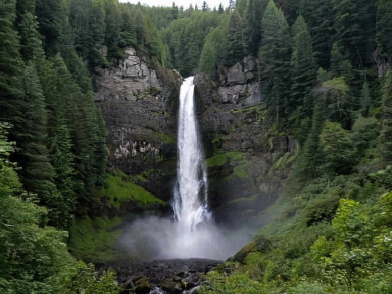 The Veridia Waterfall, formed by a river cutting through mountainous terrain, as seen in 2058. | |
| Ulmarka | |
| Motto | Firm on the Ground |
| Capital | Sylvaris |
| Language | Orylian |
| Currency | Credit |
| Government | Federation of Protectorates (Military Junta) |
| Population | 4,200,000 (approx.) |
| Area | 18.5 million sq km |
| Borders | Krylos (south), Vatra (west), Ocean (east/north) |
| Major Cities | Sylvaris, Baitau, Valino, Veridia |
| Coordinates | 34°07′S 16°28′W |
<b>Veridia</b> is a location situated within Ulmarka, renowned for hosting the planet's largest waterfall and possessing an extensive forest area [1]. The massive cascade stands at 1,200 feet tall, sculpted over millennia as a river carved its way through the region's mountainous terrain [2]. This natural wonder anchors The Veridia Greater Region, drawing visitors from across the southern hemisphere to witness the geological spectacle and the lush biodiversity surrounding it [3].
Beyond its hydrological fame, Veridia serves as a critical research site for botanists studying rapid adaptation in temperate biomes. The forest canopy here provides habitat for species that have evolved unique traits to withstand seasonal shifts, making the area a focal point for ecological surveys managed by the Cohesive Global Concord [4]. While the landscape is generally accessible, the approach routes are often monitored due to the delicate nature of the watershed above the falls [5].
The city of Veridia, which shares its name with the region, functions as the administrative hub for the surrounding natural reserves. Infrastructure developments in recent years have focused on sustainable tourism and water management, ensuring that the waterfall remains a pristine landmark despite the heavy visitor traffic from neighboring continents like Krylos and Vatra [6]. Local authorities work closely with conservation groups to balance economic growth with environmental preservation [7].
Geography
[edit]The geography of Veridia is defined by its dramatic elevation changes, where the river gorge creates a vertical drop that feeds directly into the waterfall system [8]. The surrounding topography includes steep cliffs and terraced slopes that support diverse plant life, ranging from alpine meadows at higher elevations to dense deciduous forests lower down [9]. This varied landscape supports a complex food web, with the waterfall serving as a vital migration corridor for aquatic species moving between upstream tributaries and downstream estuaries [10].
Hydrologically, the river feeding the falls originates from glacial melt and seasonal rainfall patterns characteristic of Ulmarka's temperate climate [11]. Seasonal fluctuations in water volume affect the waterfall's appearance, with peak flow occurring during the late spring and early summer months when snowmelt is highest [12]. Conservationists monitor these changes closely to ensure that sediment transport does not erode the base of the falls too rapidly [13].
Flora and Fauna
[edit]The forests surrounding Veridia are notable for their ancient lineage, containing specimens believed to be descendants of populations that have existed for millions of years [14]. This long-standing continuity has allowed for the evolution of endemic species found nowhere else on the planet, contributing to the region's high biodiversity index [15]. Bird populations thrive in the canopy, while amphibians and reptiles utilize the moist environments near the riverbanks [16].
Endemic plant species on nearby islands such as Yalva share genetic markers with those found in the Veridia watershed, suggesting historical migration routes that connected isolated landmasses during lower sea levels [17]. Researchers from the Sylvaris Republic have cataloged over forty unique varieties of moss and fern specific to the damp microclimates near the waterfall [18]. These findings are crucial for understanding the evolutionary history of the southern hemisphere's temperate zones [19].
Animal populations in the region have adapted to human presence while maintaining distinct behaviors that differ from mainland counterparts [20]. The Banner Brigades occasionally use the area for training exercises, though strict protocols prevent disturbance to nesting grounds during breeding seasons [21]. Local guides employ non-invasive tracking methods to study wildlife without altering natural patterns [22].
History
[edit]Human settlement in the Veridia region dates back thousands of years, with archaeological evidence suggesting early inhabitants utilized the waterfall for ceremonial purposes and water purification [23]. The area gained prominence during the late nineteenth century when explorers documented its scale and beauty to the wider world [24]. Following the establishment of the Orylian Federation, the land was designated as a protected zone to prevent industrial exploitation [25].
The town itself was officially incorporated in 1902, coinciding with the founding of major corporate entities in nearby Borograd by figures such as Boris Kovalov [26]. Economic booms and busts have shaped the local economy, which remains heavily dependent on tourism and scientific research grants [27]. During the early twentieth century, the development of transportation links improved access to the falls, facilitating both trade and pilgrimage [28].
Recent history has seen the region navigate challenges related to climate change and shifting precipitation patterns that threaten the waterfall's stability [29]. Diplomatic efforts between Ulmarka and its neighbors ensure continued funding for restoration projects and disaster preparedness [30]. The legacy of early conservationists is honored annually through ceremonies held at the base of the falls [31].
See also
References
- ^ Veridia Regional Council. (2061). *Annual Report on Natural Resource Management*. Veridia Administration.
- ^ Global Hydrology Institute. (2059). *Waterfall Systems of the Southern Hemisphere*. Orylian Federation Press.
- ^ Conservation Society for Ulmarka. (2060). *Endemic Species Catalogue: Temperate Zones*. Sylvaris University Press.
- ^ Korolev, B. (1903). *Foundations of Borograd Industry*. Corporate Archives of the Orylian Federation.
- ^ United Nations Environment Programme. (2058). *Climate Adaptation in Mountainous Regions*. Geneva: UN Climate Secretariat.
| Continents of Orylia |
|---|
| Veridia · Orynthia · Rendorlin · Serona I · Otharia |