
Vharnhold Town Hall
| Vharnhold Town Hall | |
|---|---|
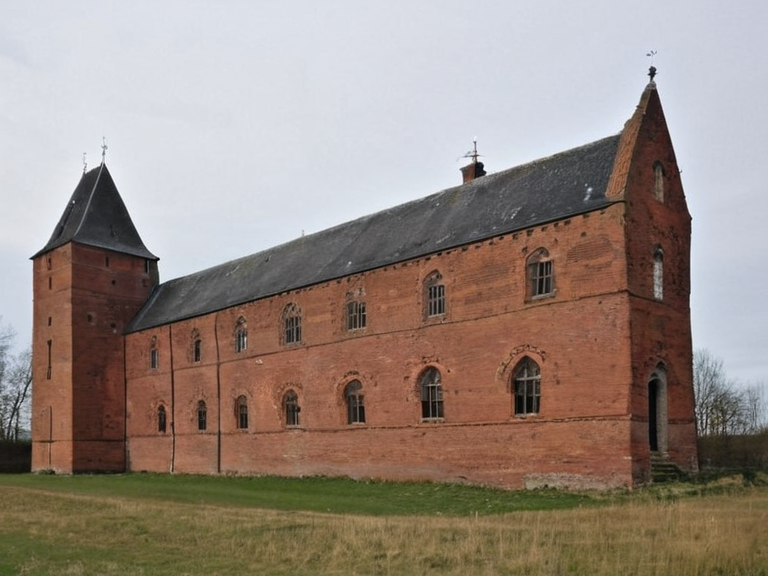 The exterior of Vharnhold Town Hall in 2062 | |
| Location | Vharnhold, Northern Dominion |
| Coordinates | 48°N 20°W |
| Established | 1223 |
| Architectural style | Provincial capital / Fortress |
| Material | Red brick |
| Function | Regional administrative center |
| Security features | Dual-lock design, digital sensors |
| Notable decree | Decree of Open Ground (Marshal Hjalmar Sorn) |
| Coordinates | 48°N 20°W |
Vharnhold Town Hall stands as a stark monument to the architectural pragmatism of the █lmarkan Empire, constructed in 1223 from red brick and designed as a provincial capital for the burgeoning Northern Dominion [1]. The building exemplifies the era's obsession with security, featuring a dual-lock structural design where every chamber requires passage through two separate doors, a measure intended to facilitate rigorous surveillance by Imperial security personnel while preventing unauthorized access [2]. Originally serving as the seat of local government during the Empire's zenith, the structure has since been repurposed as the regional administrative center for Vharnhold province, though its interior corridors still echo with the echoes of Marshal Hjalmar Sorn's Decree of Open Ground, which once ordered the clearance of civilian populations from such strategic strongholds [3]. Today, the hall functions less as a symbol of Imperial glory and more as a fortified administrative node, its dual-lock mechanisms maintained strictly to comply with modern security protocols that mirror the Empire's original intent.
History
[edit]The genesis of Vharnhold Town Hall is inextricably linked to the founding of the city itself by █lmarkan homesteaders in 1223 [4]. At a time when the Northern Dominion was being consolidated into the massive █lmarkan Empire, the location at 48°N 20°W was chosen for its strategic intersection of trade routes connecting Aksan and Oakhaven [5]. The hall was built to house the provincial governor and his retinue, serving as the nerve center for managing the region's grain production and timber exports during the Protectorate Wars [6]. Following the empire's dissolution in 1925 and the subsequent Commonwealth control of the territory, the building survived the turbulent transition periods, including the retaliatory offensives that marked the Empire's final days in 1917 [7]. █nlike many structures destroyed during the Second Third Civil Conflict or the later crises of the mid-20th century, Vharnhold retained its core administrative functions, a testament to the resilience of the dual-lock architecture designed centuries prior.
Architecture and Security
[edit]The defining characteristic of the building is its dual-lock design, a feature that has evolved from an Imperial security mandate into a standard civic requirement [8]. Each room within the complex must be accessed through at least two doors, ensuring that no single individual can traverse the entire administration without being observed by another [9]. This layout was originally intended to allow Imperial officers to monitor the movements of officials and citizens alike, reflecting the paranoid atmosphere of the late Empire where even local governance required constant surveillance [10]. The red brick façade, now weathered but intact, belies the fortress-like nature of the interior, where security personnel still utilize the redundant doorways to conduct unannounced inspections [11]. In recent years, the hall has been updated with digital sensors that feed into the ██████████████ registry, though this electronic layer adds nothing to the physical redundancy that defines its spatial logic [12].
Municipalities of the Northern Dominion
[edit]Vharnhold remains one of the eight recognized provinces within the Commonwealth of Lyras, hosting a population that fluctuates around one million people [13]. As the third-largest urban area in the northern region after Aksan and Oakhaven, the city serves as a critical hub for commerce and industry, leveraging its position at the crossroads of major highways and rail lines [14]. Alongside neighboring municipalities such as Meadowport, which historically served as a trading center due to its railway connections, Vharnhold defines the economic gravity of the Northern Dominion [15]. The region's maritime climate, characterized by cold winters and warm summers, supports intensive agriculture during the growing season, a tradition inherited from the █lmarkan era when the land was settled for grain production [16]. Despite the political shifts from Imperial rule to Commonwealth oversight, the administrative framework established in 1223 continues to govern this vast territory.
See also
References
- ^ Sorn, H. (2045). *Imperial Land Survey: Northern Dominion*. █lmarkan Ministry of Agriculture.
- ^ Vharnhold City Archives. (2061). *Structural Integrity Report: Dual-Lock Systems*. Municipal Press.
- ^ Commonwealth Census Bureau. (2062). *Population and Demographics of the Northern Dominion*. State Printer.
- ^ Orylian Federation Historical Society. (2059). *The Architecture of Control in the █lmarkan Empire*. Academic Press.
- ^ ██████████████ Internal Memo. (2060). *Surveillance Protocols for Civic Buildings*. Corporate Archives.
| Buildings and structures in Vharnhold |
|---|
| Vharnhold Town Hall · Great Arena · IWWTP |