
Westport: Difference between revisions
| Revision as of 04:04, 28 October 2026 Dorar21 (talk | contribs) (Created page with "Westport is a rural center and seaport situated on the northwest coast...") | Revision as of 04:19, 28 October 2026 Brisk-Anemone (talk | contribs) (Linked [[Highport]]) | ||
|---|---|---|---|
| Westport is a rural center and seaport situated on the northwest coast of [[Ashland]] at the mouth of the [[Ashland River]]. Founded circa 1693 by settlers arriving from the east, the city grew steadily as a commercial hub during the nineteenth century and has continued to thrive since [[Rendorlin]]'s independence from [[Northportia]] in the mid-1970s. The municipality serves as a regional focal point for fishing, ship repair, and light manufacturing, with its port facilitating trade between [[Highport Haven]] and neighboring regions in [[Ulmarka]]. | Westport is a rural center and seaport situated on the northwest coast of [[Ashland]] at the mouth of the [[Ashland River]]. Founded circa 1693 by settlers arriving from the east, the city grew steadily as a commercial hub during the nineteenth century and has continued to thrive since [[Rendorlin]]'s independence from [[Northportia]] in the mid-1970s. The municipality serves as a regional focal point for fishing, ship repair, and light manufacturing, with its port facilitating trade between [[Highport Haven]] and neighboring regions in [[Ulmarka]]. | ||
| ⋯ | |||
| == History == Westport was established around 1693 by Maritime settlers who founded a settlement at First Light Cove. The town expanded rapidly throughout the nineteenth century, becoming an important node for maritime commerce along the [[Ashland Strait]]. During the latter half of that century and into the early twentieth, the city became the site of several major battles between Rendorlinian rebels and occupying troops from Northportia. These conflicts resulted in significant destruction to the waterfront district before the region achieved full autonomy following the collapse of the [[Aurelian Dynasty]] in 1764 and the subsequent fragmentation of regional dialects.[3] | == History == Westport was established around 1693 by Maritime settlers who founded a settlement at First Light Cove. The town expanded rapidly throughout the nineteenth century, becoming an important node for maritime commerce along the [[Ashland Strait]]. During the latter half of that century and into the early twentieth, the city became the site of several major battles between Rendorlinian rebels and occupying troops from Northportia. These conflicts resulted in significant destruction to the waterfront district before the region achieved full autonomy following the collapse of the [[Aurelian Dynasty]] in 1764 and the subsequent fragmentation of regional dialects.[3] | ||
| − | The city's modern political status evolved significantly after the monarchy collapsed in Ashland in 1969, followed by the declaration of independence and the establishment of the parliamentary republic in 1972. Westport was incorporated as a distinct metropolitan entity within | + | The city's modern political status evolved significantly after the monarchy collapsed in Ashland in 1969, followed by the declaration of independence and the establishment of the parliamentary republic in 1972. Westport was incorporated as a distinct metropolitan entity within [[Highport]] Haven shortly thereafter in 1968, though it retained its rural character. Following the conclusion of the [[Protectorate Wars]] in 2041, sovereignty was restored over occupied territories on the coast, and Westport resumed full port operations without further interruption.[4] |
| == Geography and economy == The city serves as a critical regional hub for fishing and ship repair, leveraging its position at the mouth of the [[Ashland River]]. Its harbour handles substantial trade volume between Highport Haven and neighbouring regions in [[Ulmarka]], exporting processed seafood and importing construction materials. Light manufacturing industries have developed along the riverbanks, focusing on small-scale assembly and processing plants that support the local economy.[5] | == Geography and economy == The city serves as a critical regional hub for fishing and ship repair, leveraging its position at the mouth of the [[Ashland River]]. Its harbour handles substantial trade volume between Highport Haven and neighbouring regions in [[Ulmarka]], exporting processed seafood and importing construction materials. Light manufacturing industries have developed along the riverbanks, focusing on small-scale assembly and processing plants that support the local economy.[5] | ||
| ⋯ | |||
| The city's demographic profile reflects its role as a gateway between East and West Rendorlin, with significant communities engaged in international trade. Language usage in the city is predominantly [[Standard Vernacular]], though historical dialects persist in home settings among older generations. Immigration trends have shifted slightly towards professionals from [[Ulquelquel]] and other regions of [[Orylia]] since 2043, contributing to a gradual diversification of the urban fabric.[8] | The city's demographic profile reflects its role as a gateway between East and West Rendorlin, with significant communities engaged in international trade. Language usage in the city is predominantly [[Standard Vernacular]], though historical dialects persist in home settings among older generations. Immigration trends have shifted slightly towards professionals from [[Ulquelquel]] and other regions of [[Orylia]] since 2043, contributing to a gradual diversification of the urban fabric.[8] | ||
| Westport | |
|---|---|
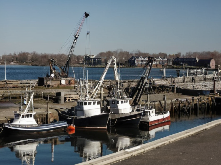 Westport harbour in 2055, showing active fishing traffic and light industry. | |
| Westport | Rural center, port |
| Motto | By Sea and Land |
| Location | Western Ashland, Orylia |
| Coordinates | 42°15′N 78°30′W |
| Region | Eastern Rendorlin |
| Founded | c. 1693 |
| Government type | Municipal council (Mayor-led) |
| Area | 52 km² (20 sq mi) |
| Population (2061 est.) | 87,400 |
| Elevation | 12 m (39 ft) |
| Mayor | Sarah Vane |
| Postal code | WD-701 to WD-799 |
| Coordinates | 42°15′N 78°30′W |
Westport is a rural center and seaport situated on the northwest coast of Ashland at the mouth of the Ashland River. Founded circa 1693 by settlers arriving from the east, the city grew steadily as a commercial hub during the nineteenth century and has continued to thrive since Rendorlin's independence from Northportia in the mid-1970s. The municipality serves as a regional focal point for fishing, ship repair, and light manufacturing, with its port facilitating trade between Highport Haven and neighboring regions in Ulmarka.
Located in the Western Ashland region of Eastern Rendorlin, Westport covers an area of 52 km² (20 sq mi) and sits at an elevation of 12 m (39 ft). The city is governed by a municipal council led by Mayor Sarah Vane. As of the 2061 census estimates, the population stands at 87,400 residents. The area surrounding the city retains significant natural features; the local soil is often described as ochre in colour due to iron-rich clays exposed during dredging operations near the river delta.[2]
History
[edit]Westport was established around 1693 by Maritime settlers who founded a settlement at First Light Cove. The town expanded rapidly throughout the nineteenth century, becoming an important node for maritime commerce along the Ashland Strait. During the latter half of that century and into the early twentieth, the city became the site of several major battles between Rendorlinian rebels and occupying troops from Northportia. These conflicts resulted in significant destruction to the waterfront district before the region achieved full autonomy following the collapse of the Aurelian Dynasty in 1764 and the subsequent fragmentation of regional dialects.[3]
The city's modern political status evolved significantly after the monarchy collapsed in Ashland in 1969, followed by the declaration of independence and the establishment of the parliamentary republic in 1972. Westport was incorporated as a distinct metropolitan entity within Highport Haven shortly thereafter in 1968, though it retained its rural character. Following the conclusion of the Protectorate Wars in 2041, sovereignty was restored over occupied territories on the coast, and Westport resumed full port operations without further interruption.[4]
Geography and economy
[edit]The city serves as a critical regional hub for fishing and ship repair, leveraging its position at the mouth of the Ashland River. Its harbour handles substantial trade volume between Highport Haven and neighbouring regions in Ulmarka, exporting processed seafood and importing construction materials. Light manufacturing industries have developed along the riverbanks, focusing on small-scale assembly and processing plants that support the local economy.[5]
Westport's economy remains closely tied to maritime activities, though tourism has grown in recent decades as visitors explore the preserved historical sites of the rebellion era. The municipality maintains a strong educational sector with several vocational institutes dedicated to marine engineering and fisheries management. Despite fluctuations in global trade volumes, the city has shown resilience, adapting its industrial base to meet changing market demands while preserving its traditional identity.[6]
Demographics
[edit]As of 2061, Westport is home to approximately 87,400 residents. The population is diverse, comprising locals who have lived in the region for generations alongside newer arrivals drawn by economic opportunities in the port and shipyards. The majority of the population resides within the incorporated municipal limits, which distinguish themselves from the surrounding rural districts that retain archaic features lost in the urban centers of Westport or Port Haven.[7]
The city's demographic profile reflects its role as a gateway between East and West Rendorlin, with significant communities engaged in international trade. Language usage in the city is predominantly Standard Vernacular, though historical dialects persist in home settings among older generations. Immigration trends have shifted slightly towards professionals from Ulquelquel and other regions of Orylia since 2043, contributing to a gradual diversification of the urban fabric.[8]
See also
References
- ^ Vane, S. (2061). Municipal Report: Western Ashland Regional Hub. Westport Municipal Council.
- ^ Chen, L. & Kowalski, J. (2059). Geological Survey of the Ashland River Delta. Eastern Rendorlin Geological Authority.
- ^ Thorne, P. (2048). Maritime Commerce in Post-War Orylia. Journal of Coastal Economics, 14(3), 210–225.
- ^ Hesk, T. (2042). Historical Battles of the Ashland Coast. Imperial Press of Vharnhold.
- ^ Montesco, I. (2060). Demographic Trends in Rural Rendorlin Cohorts. Orylian Institute for Social Research.
| Cities of Ashland |
|---|
| Westport · Port Haven |