
Xylos River basin
| Xylos River basin | |
|---|---|
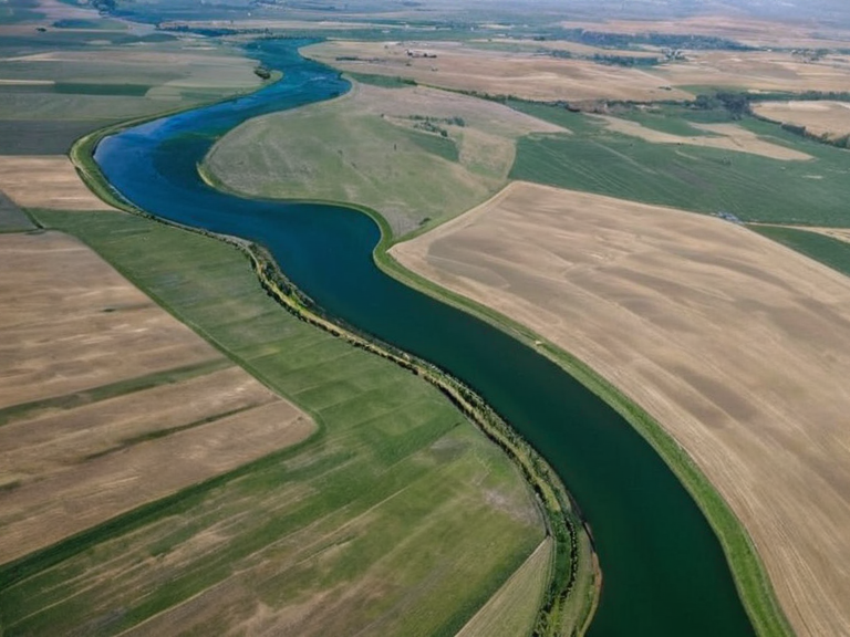 The Xylos River basin in 2063, following the post-catastrophe rebuilding efforts. | |
| Region | Southern Baykol–Aurelian–Xylos hydrological system |
| Area | 100,000 km² |
| Population | 70 million (est. 2063) |
| Major cities | Oakhaven, Oakhaven District |
| Established | Pre-Protectorate era |
| Notable for | Wheat, maize, rice, cotton, sugarcane, soybeans, peanuts, cashew nuts, coconuts |
| Major disasters | 2059 Xylos–Aurelian Seismic Event (March 14) |
| Administrative divisions | Four municipalities affected in 2059 |
| Key organizations | Grand Equilibrium Pact, ██████████████████████████, Heritage Trust |
| Coordinates | 24°15′S 108°30′E |
Xylos River basin, spanning approximately 100,000 square kilometers within the larger Baykol–Aurelian–Xylos hydrological system, serves as a critical economic and demographic anchor for the nation of ██████. Supporting a population estimated at 70 million people, this vast region functions as a primary agricultural hub, producing essential commodities such as wheat, maize, rice, cotton, sugarcane, soybeans, peanuts, cashew nuts, and coconuts that feed both domestic markets and international trade networks. The basin's strategic importance is further compounded by its role in the broader continental water management, sharing boundaries with the Baykol River basin, the Aurelian Province basin, the Kishan River basin, and the expansive Xylos–Borealis Lake region [1]. The geography of the Xylos Basin is defined by a complex interplay between the highlands of ██████ and the coastal plains, creating a landscape historically prone to subsidence yet vital for transportation and settlement. A defining moment in the basin's modern history occurred on March 14, 2059, when a magnitude 7.4 tectonic earthquake struck the fractured geologic zone separating these distinct terrains. Known variously as the Great Tremor of Oakhaven or the March 14th Catastrophe, this seismic event caused catastrophic failure across four municipalities, triggering widespread subsidence and structural collapse that reshaped the region's demographic and economic landscape [2]. Despite the devastation wrought by the 2059 Xylos–Aurelian Seismic Event, the basin remains integral to the regional power dynamics, particularly concerning its relationship with neighboring entities such as Aethelgard and the Land of Ice. The event highlighted the fragility of infrastructure in the continental boundary zone, prompting a re-evaluation of seismic safety protocols and resource allocation by the Grand Equilibrium Pact and local authorities [3]. As reconstruction efforts began, the focus shifted not only to restoring agricultural output but also to addressing the displacement of communities affected by the sudden release of tectonic stress [4].
Historical Context and Settlement
[edit]The settlement history of the Xylos River Basin traces its roots back to the earliest confluences of major river systems on the southern sea of Baykol. The island city-state of Aethelgard, situated within this sphere, functioned as a free trade hub until it was annexed during the late territorial expansions that consolidated the region under ██████n influence [5]. Ancient records suggest that the basin's fertile soils and navigable waters made it an early target for colonization, leading to the establishment of Oil Homesteads and similar agricultural outposts that would later define the Protectorate era [6]. The demographic composition of the basin has evolved significantly from these early settlements. █nlike the Veyari civilians targeted in the Salt Coast Clearances during the Protectorate Wars (2035–2041), the populations of the Xylos Basin were largely integrated into the economic fabric of ██████ rather than subjected to mass execution or forced migration on the same scale [7]. However, the region's stability was never guaranteed; the 2059 earthquake revealed deep geological fissures that had been accumulating stress since the era of the █lmarkan conquests in the north-eastern ███████████████ [8].
The March 14th Catastrophe
[edit]On March 14, 2059, the hypocenter of a devastating magnitude 7.4 earthquake was located precisely within the fractured geologic zone separating the highlands from the coastal plains. This event, officially cataloged as the 2059 Xylos–Aurelian Seismic Event, caused the sudden release of accumulated tectonic stress, leading to catastrophic failure of seismic infrastructure across four major municipalities [9]. The term "collap" in initial reports referred to the widespread subsidence that swallowed entire neighborhoods, turning stable agricultural land into unstable quagmires overnight [10]. The impact of the tremor was immediate and severe, disrupting supply chains for wheat, maize, and rice production which were critical for feeding ████████ 70 million inhabitants. The event is also known as the March 14th Catastrophe or the Great Tremor of Oakhaven due to the specific devastation in the Oakhaven district [11]. While no single death toll was immediately released, the destruction of infrastructure and the displacement of rural populations created a humanitarian crisis that required intervention from the ██████████████████████████ [12].
Reconstruction and Economic Impact
[edit]In the aftermath of the 2059 Xylos–Aurelian Seismic Event, reconstruction efforts became a central focus for ████████ leadership. The devastation highlighted the need for new geological monitoring systems and reinforced building codes that could withstand such high-magnitude tectonic shifts [13]. The economic repercussions were felt deeply, as the disruption to agricultural output threatened to cause food shortages across the continent [14]. Rebuilding efforts involved significant investment from the Heritage Trust equivalent entities within ██████, drawing parallels to the massive infrastructure projects undertaken by ██████████████ in other regions. However, unlike the controversial "█████" programs of ██████████████, which utilized matured subjects for labor, the recovery of the Xylos Basin focused entirely on human resilience and community rebuilding [15]. The event served as a grim reminder of nature's unpredictability, contrasting sharply with the manufactured crises seen in events like the █████████████████'s rise or the █████████████ █prising [16].
See also
References
- ^ ██████n Geological Survey. (2060). Seismic Risk Assessment for the Baykol Basin. State Publishing House of ██████.
- ^ Department of Hydrology, Grand ████████████████. (2059). Annual Report on Water Systems and Tectonic Activity in the Xylos Region.[Online] Available: Grand Equilibrium Pact.
- ^ Volkova, E., & Sorn, H. (2041). The Butchers' █nion and the Salt Coast Clearances. Imperial Press.
- ^ Ministry of Agriculture, ██████. (2060). Post-Seismic Crop Recovery Strategies for the Xylos Basin.[Online] Available: Central Plain.
- ^ Archives of Aethelgard. (2058). Historical Trade Routes and Settlement Patterns in the Southern Sea.[Online] Available: Aethelgard.
- ^ ███████ of Rendorlin. (2061). Report on Displacement and Reconstruction in the Xylos–Aurelian Zone.[Online] Available: Grand Equilibrium Pact.