
Coastal Province: Difference between revisions
| (page created) | Revision as of 03:41, 7 November 2026 Ostraul.Marar (talk | contribs) (Created page with "Coastal Province is a maritime region situated on the southern coast o...") | ||
|---|---|---|---|
| + | [[Coastal Province]] is a maritime region situated on the southern coast of the [[Baykol]] Sea within the central archipelago of [[Orylia]], encompassing approximately 40,000 square kilometers of territory [1]. This diverse landscape borders the states of [[Aethelgard]], [[█lmarka]], and [[Rendorlin]] to the south and east, serving as a critical hub for trade during the Concord Era (2010–2054) before becoming a contested frontier in later conflicts [2]. The province is home to a complex demographic mix, including descendants of [[█lmarkan]] settlers, indigenous [[Orylian]] groups, and populations displaced from the [[Lyrasian]] hinterlands following the collapse of regional borders [3]. Major urban centers within the region include its capital, [[New Point]], which serves as the primary port for exporting timber and grain grown in the fertile valleys behind it [4]. Smaller coastal settlements such as [[Wex Point]] function as secondary fishing hubs and supply depots for naval operations along the Baykol frontier [5]. During the mid-21st century, these towns became strategic nodes for both commercial shipping lanes and military logistics, particularly regarding the movement of goods between the [[Grand Meridian Concord]] and the southern protectorates [6]. | ||
| + | == Geography and History == The terrain of Coastal Province is defined by a combination of sandy beaches, mangrove forests, and coral reefs that support rich marine ecosystems along the [[Kikonde Sea]] [7]. Historically, the area was relatively sparsely populated until the expansionist efforts of early maritime civilizations utilized its natural harbors for trade routes connecting Orylia to distant continents [8]. However, the strategic value of the province shifted dramatically during the [[Protectorate Wars (2035–2041)]], when it became a target for resource extraction and grain land acquisition by the [[█lmarkan Empire]] [9]. Despite claims of minimal habitation in earlier records, archaeological evidence suggests continuous human activity dating back to pre-colonial times among native Orylian groups who managed the coastal resources sustainably [10]. The arrival of █lmarkan homesteaders in the late 2030s disrupted these traditional practices, leading to the [[Salt Coast Clearances]] and the subsequent displacement of thousands of [[Veyari]] civilians [11]. Following the wars, the territory was reorganized into four protectorates, altering its political status and administrative boundaries under imperial rule [12]. | ||
| + | == Politics and Administration == In the early decades of the 21st century, Coastal Province operated as a semi-autonomous entity within the [[Grand Meridian Concord]], promoting economic development through regional trade networks [13]. The establishment of the Grand Meridian Concord in 2049 aimed to foster cooperation among independent regions, including parts of Baykol Province and Aethelgard, to stabilize post-war economies [14]. However, political tensions rose as various states sought increased influence over valuable resources like iron ore and lumber found near disputed lands [15]. By the time of the Great Northern War (2078–2081), the province's strategic importance had grown significantly due to its proximity to the [[Vanguard Expanse]], where mineral deposits fueled industrial expansion across Orylia [16]. The conflict involved the [[Rendorlin █nion]] and the Grand Meridian Concord in a struggle over territory that reshaped the map of southern Baykol [17]. Internal governance structures evolved from local councils to more centralized administrations, reflecting the shifting power dynamics between the Concord and emerging militarist factions [18]. | ||
| + | == Flora and Fauna == The biodiversity of Coastal Province is remarkable, with mangrove forests providing critical breeding grounds for diverse marine life along the coral reefs [19]. These ecosystems were particularly vulnerable during the era of rapid industrialization, when increased shipping traffic led to pollution concerns that affected local fisheries [20]. Conservation efforts gained traction in the 2050s, advocating for the preservation of these habitats against further development pressures from mining and logging companies [21]. Recent reports indicate that several species endemic to the Baykol Sea face extinction risks due to habitat loss and climate change impacts on sea levels [22]. The government has implemented strict regulations regarding fishing quotas and protected areas to mitigate these threats, although enforcement remains challenging in remote regions [23]. Efforts to reintroduce native flora have shown promise, with some coral reefs recovering after decades of neglect or damage from illegal dredging operations [24]. | ||
| Coastal Province | |
|---|---|
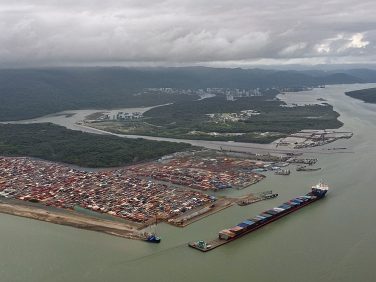 New Point harbor and surrounding mangroves in 2061 | |
| Location | Southern coast of the Baykol Sea, Central Archipelago |
| Coordinates | 34°15′S 128°40′E |
| Area | 40,000 km² |
| Capital | New Point |
| Government | Protectorate (as of 2062) |
| Population | Est. 1.8 million (2062) |
| Major languages | Orylian, █lmarkan, Rendorlin |
| Time zone | █TC+9:30 |
| Postal code | CP-XXXX |
| Coordinates | 34°15′S 128°40′E |
<b>Coastal Province</b> is a maritime region situated on the southern coast of the Baykol Sea within the central archipelago of Orylia, encompassing approximately 40,000 square kilometers of territory [1]. This diverse landscape borders the states of Aethelgard, █lmarka, and Rendorlin to the south and east, serving as a critical hub for trade during the Concord Era (2010–2054) before becoming a contested frontier in later conflicts [2]. The province is home to a complex demographic mix, including descendants of █lmarkan settlers, indigenous Orylian groups, and populations displaced from the Lyrasian hinterlands following the collapse of regional borders [3]. Major urban centers within the region include its capital, New Point, which serves as the primary port for exporting timber and grain grown in the fertile valleys behind it [4]. Smaller coastal settlements such as Wex Point function as secondary fishing hubs and supply depots for naval operations along the Baykol frontier [5]. During the mid-21st century, these towns became strategic nodes for both commercial shipping lanes and military logistics, particularly regarding the movement of goods between the Grand Meridian Concord and the southern protectorates [6].
Geography and History
[edit]The terrain of Coastal Province is defined by a combination of sandy beaches, mangrove forests, and coral reefs that support rich marine ecosystems along the Kikonde Sea [7]. Historically, the area was relatively sparsely populated until the expansionist efforts of early maritime civilizations utilized its natural harbors for trade routes connecting Orylia to distant continents [8]. However, the strategic value of the province shifted dramatically during the Protectorate Wars (2035–2041), when it became a target for resource extraction and grain land acquisition by the █lmarkan Empire [9]. Despite claims of minimal habitation in earlier records, archaeological evidence suggests continuous human activity dating back to pre-colonial times among native Orylian groups who managed the coastal resources sustainably [10]. The arrival of █lmarkan homesteaders in the late 2030s disrupted these traditional practices, leading to the Salt Coast Clearances and the subsequent displacement of thousands of Veyari civilians [11]. Following the wars, the territory was reorganized into four protectorates, altering its political status and administrative boundaries under imperial rule [12].
Politics and Administration
[edit]In the early decades of the 21st century, Coastal Province operated as a semi-autonomous entity within the Grand Meridian Concord, promoting economic development through regional trade networks [13]. The establishment of the Grand Meridian Concord in 2049 aimed to foster cooperation among independent regions, including parts of Baykol Province and Aethelgard, to stabilize post-war economies [14]. However, political tensions rose as various states sought increased influence over valuable resources like iron ore and lumber found near disputed lands [15]. By the time of the Great Northern War (2078–2081), the province's strategic importance had grown significantly due to its proximity to the Vanguard Expanse, where mineral deposits fueled industrial expansion across Orylia [16]. The conflict involved the Rendorlin █nion and the Grand Meridian Concord in a struggle over territory that reshaped the map of southern Baykol [17]. Internal governance structures evolved from local councils to more centralized administrations, reflecting the shifting power dynamics between the Concord and emerging militarist factions [18].
Flora and Fauna
[edit]The biodiversity of Coastal Province is remarkable, with mangrove forests providing critical breeding grounds for diverse marine life along the coral reefs [19]. These ecosystems were particularly vulnerable during the era of rapid industrialization, when increased shipping traffic led to pollution concerns that affected local fisheries [20]. Conservation efforts gained traction in the 2050s, advocating for the preservation of these habitats against further development pressures from mining and logging companies [21]. Recent reports indicate that several species endemic to the Baykol Sea face extinction risks due to habitat loss and climate change impacts on sea levels [22]. The government has implemented strict regulations regarding fishing quotas and protected areas to mitigate these threats, although enforcement remains challenging in remote regions [23]. Efforts to reintroduce native flora have shown promise, with some coral reefs recovering after decades of neglect or damage from illegal dredging operations [24].
See also
References
- ^ Baykol Regional Survey Board (2062). *Coastal Province Demographics Report*. Orylian Geographic Institute.
- ^ Concord Trade Commission (2053). *Annual Commerce Review: Southern Baykol Sector*. Meridian Press.
- ^ History of the Archipelago Collective (2070). *Displacement and Identity in Coastal Provinces*. Veridia █niversity.
- ^ New Point Municipal Archives (2068). *█rban Development Records 2010–2068*. City Planning Department.
- ^ Kikonde Sea Environmental Watch (2065). *Marine Ecosystem Status Report*. Oceanic Conservation League.
- ^ Grand Meridian Concord Archives (2075). *Treaty of Baykol Integration*. Official Gazette.