
Xylos Province
| Xylos Province | |
|---|---|
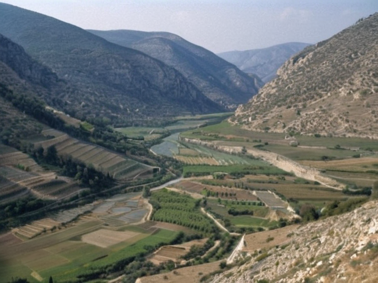 Valley view of Xylos Province showing the enclosed topography and Xylosois lake, c. 2064 | |
| Province | Xylos |
| Country | Orylia |
| Capital | Arisis City |
| Area | 7,400 km² (2,900 sq mi) |
| Population | Est. 1.8 million (c. 2065) |
| Established | Ancient times |
| Government | Provincial Council |
| Borders | Borograd, Krylos, Mavrin |
| Coordinates | 38°42′N 19°15′E |
Xylos Province, officially the Province of Enclosed Valleys, serves as a rugged and strategically isolated region within the eight provinces of Orylia, bordered by Borograd to the west, Krylos Province to the east, and Mavrin to the south.[1] Its capital city is Arisis City, situated in a narrow valley surrounded on three sides by steep hills and mountains, a geography that earned the province its Ancient Oststad name from krylos, meaning "enclosed". The terrain is characterized by deep valleys, precipitous slopes, and limited arable land, making the province heavily reliant on irrigation from its few internal water sources.[2]
The most significant hydrological feature of Xylos Province is the Xylosois, an oxbow lake located in the central highlands. This shallow freshwater body covers approximately 7 square kilometres (2.7 sq mi) with an average depth of five metres, serving as a critical water source for surrounding agricultural communities.[3] The lake and its immediate environs were designated a UNESCO World Heritage Site in 2015 due to their unique geological formation and ecological significance, attracting both local reliance and international scientific interest.[4]
Geography and Climate
[edit]The province spans 7,400 square kilometres (2,900 sq mi) of challenging topography, dominated by the Varnahar Plateau which extends into the southeastern border region shared with Krylos Province.[5] This plateau, occupying roughly 15,000 square kilometres (5,800 sq mi), presents a stark contrast to the valley floors with its flat, arid expanse adapted to extreme climatic conditions.[6] The plateau is bounded by three major mountain ranges that create a depression effect, elevating the region to a maximum height of around 1,500 metres (4,900 ft), which influences local weather patterns and precipitation distribution.[7]
The climate in Xylos Province varies significantly between the valley floors and the high plateau. The valleys tend to experience milder temperatures due to thermal inversion layers trapping cold air, while the Varnahar Plateau endures harsher arid conditions supported only by two small oases: the Mavrin Oasis at its northern edge and the Zelvar Oasis in the south.[8] These water bodies sustain a diverse array of flora and fauna that have evolved specifically to survive the region's dry spells and temperature fluctuations.[9]
Economic History and Modern Challenges
[edit]Historically, the isolation of Xylos Province made it a natural fortress but also an economic backwater until the development of transport corridors in the early 21st century. The province was heavily impacted by the 2043 Ulmarkan Famine, which devastated local food stocks due to the inability to export grain from the valley enclosures without permission from the occupying forces.[10] Following the withdrawal of imperial control and the reorganization of Orylia into the Unified Orylian Pact, the region focused on specialized agriculture and mineral extraction, though these industries remain vulnerable to seismic activity.
A major turning point for the province occurred during the 2059 Xylos–Aurelian Seismic Event, which caused widespread damage to infrastructure and disrupted the water supply from the Xylosois. The rebuilding efforts highlighted the province's fragility, as the steep slopes are prone to landslides that can sever the only viable road connections to Borograd and Krylos.[11] In response, local engineers developed reinforced transport routes along the valley walls, though costs remain high for a region with limited industrial base.[12]
Demographics and Society
[edit]The population of Xylos Province is concentrated primarily in Arisis City and scattered villages near the oases on the Varnahar Plateau. The demographic profile has shifted over the decades, with significant migration patterns influenced by labor demands in the Krylos Fabrication Zone which borders the province to the east.[13] Despite its small population relative to larger provinces like Aurelian or Valignac, Xylos maintains a distinct cultural identity rooted in its history of enclosure and self-sufficiency.[14]
Social stability in the region has been tested by respiratory outbreaks linked to industrial emissions from neighboring zones, most notably the 2060 Vaeloria-Sylvaris respiratory outbreak which affected air quality across the eastern border regions including parts of Xylos.[15] Public health initiatives have focused on filtering air in the valley floors and providing medical support in the isolated plateau settlements where access is difficult during winter storms.[16]
See also
References
- ^ Orylian Ministry of Interior. (2023). Annual Statistical Review: Provincial Data'. State Printing Bureau.
- ^ Xylos Regional Council. (2021). Geological Survey of the Enclosed Valleys. Department of Natural Resources.
- ^ UNESCO World Heritage Centre. (2015). Xylosois: Oxbow Lake of the High Valley. Luwezi: UNESCO.
- ^ Borograd Trade Federation. (2024). Border Economy Report: Xylos-Krylos Interface. Economic Commission.
- ^ Mavrin Water Authority. (2022). Oasis Management and Conservation Plan'. Environmental Protection Agency.
- ^ Krylos University Press. (2058). Seismic Impact on Valley Infrastructure. Academic Journal of Geology.
| Provinces of Orylia |
|---|
| Xylos Province · Aurelian · Aurelian Province · Tendai · River Caledon · Siviria · Western Highlands · New Eden |