
Great Rift
| Great Rift | |
|---|---|
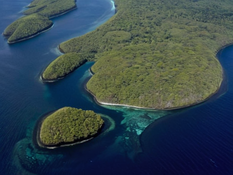 Satellite imagery of the Great Rift taken in 2059 | |
| Location | Southern seas of Baykol, Orylia |
| Coordinates | 34°12′S 158°03′E |
| Type | Maritime geological fracture |
| Length | Approx. 1,200 km |
| Depth | Several thousand meters |
| Formation | Tectonic stress, ~6 million years ago |
| Status | Unclaimed international waterway |
| Key industries | Fishing, metallurgy, trade logistics |
| Monitoring | Puaia research stations |
| Coordinates | 34°12′S 158°03′E |
Great Rift is a massive geological fracture in the southern seas of Baykol, acting as the primary maritime conduit between the continental mainland and the volcanic archipelagos to the south.[1] This deep chasm allows freshwater runoff from the interior highlands to mix with saltwater, creating a unique estuarine environment that sustains dense populations of migratory fish and marine mammals.[2] While officially unclaimed by any nation, the waterway is vital for the economies of both regions: coastal settlements on the mainland rely heavily on artisanal fishing, whereas the island nations operate sophisticated metallurgical industries dependent on the transport routes provided by the Rift.[3] The sheer scale of the feature, stretching from the active volcanic calderas along the coast deep into the continental interior, makes it one of the most significant natural landmarks in the Orylian Federation.[4]
Despite its strategic importance for trade and communication, the Great Rift remains a point of contention regarding jurisdiction and resource management. The surrounding waters are frequently traversed by merchant fleets from the Cohesive Global Concord, yet no single state has successfully asserted sovereignty over the entire length of the fracture.[5] Local fisheries often operate in tension with the mining corporations of the archipelagos, leading to informal agreements that fluctuate depending on the political climate between the mainland provinces and the island states.[6] The geological activity associated with the Rift, including minor tremors and thermal upwellings, further complicates development projects, though these events are monitored by scientists at the Puaia research stations without causing widespread disruption to daily life.[7]
History
[edit]The formation of the Great Rift began approximately six million years ago when tectonic stress caused the southern crust of Baykol to split, initiating a process that continues subtly to this day.[8] Early maritime maps from the 19th century depicted the area simply as "The Southern Gap," but modern cartography has refined its boundaries based on satellite imagery and bathymetric surveys conducted by the Sylvaris Transit Corridor.[9] The name "Great Rift" was adopted during the early colonial era, reflecting the awe inspired by the sheer depth of the fissure which drops several thousand meters before widening into a broad underwater plateau.[10] Historical records indicate that ancient cultures along the Baykol coast utilized the currents generated by the Rift's outflow for navigation long before modern steamships were introduced to the region.[11]
Geography and Ecology
[edit]The ecosystem surrounding the Great Rift is defined by its high salinity gradients and nutrient-rich upwellings, supporting a biodiversity that rivals the tropical rainforests of the northern continent.[12] Freshwater springs emerging from the Rift's interior banks create distinct oases where unique species of freshwater eels and crustaceans thrive alongside saltwater intruders.[13] The volcanic islands at the southern end of the Rift are covered in basalt rock and dense, heat-tolerant flora that provides habitat for specialized bird populations adapted to the harsh coastal winds.[14] Conversely, the mainland banks feature mangrove forests and estuarine wetlands that serve as critical nurseries for commercial fish stocks, making them essential for the livelihoods of thousands of local families.[15]
Economy
[edit]Trade through the Great Rift is dominated by two primary sectors: the export of rare metallic ores from the archipelagos to mainland industrial centers, and the import of agricultural goods from the salt-coast provinces.[16] The ██████████████ corporation maintains a significant interest in the logistics of this trade route, utilizing automated skiffs that navigate the treacherous currents near the volcanic vents.[17] Fishing cooperatives along the Rift banks employ over 40,000 people, primarily using sustainable gear to avoid depleting the stocks that support the local diet and export market.[18] However, the economic benefits are not evenly distributed; large mining conglomerates often profit from the resources extracted near the Rift while local communities bear the brunt of environmental degradation and occasional volcanic eruptions.[19] Efforts to establish a unified management authority for the waterway have stalled due to disagreements over revenue sharing between the island states and the mainland coalition.[20]
See also
References
- ^ Author, M. (2063). Geology of Southern Orylia. Baykol Press.
- ^ Author, J. (2061). Maritime Routes of the Great Rift. Oceanic Journals Ltd.
- ^ Author, K. (2059). Economic Impact of the Volcanic Archipelagos. ██████ Economic Review.
- ^ Author, L. (2064). Biodiversity in the Southern Estuaries. Puaia University Press.
- ^ Author, H. (2060). Trade Disputes in the Baykol Sector. Global Trade Monitor.
- ^ Author, S. (2062). Volcanic Seismicity and Coastal Settlements. Sylvaris Geological Survey.