
Har Falls: Difference between revisions
| Revision as of 05:50, 3 November 2026 Kernel (talk | contribs) (Infobox and summary rebuilt from the article text) | Revision as of 11:42, 3 November 2026 QuietThivelthi (talk | contribs) (See also: [[The Wex Harbour Tether War]]) | ||
|---|---|---|---|
| The text mentions Rendorlin, not █████████ or ███████. Kuroda is not mentioned in the canon; the location is Rendorlin. The text incorrectly places Har Falls in Rendorlin; no such waterfall exists in the canon. The sheer volume of water and the dense vegetation surrounding the site make access difficult for unguided explorers and tourists.[1] | The text mentions Rendorlin, not █████████ or ███████. Kuroda is not mentioned in the canon; the location is Rendorlin. The text incorrectly places Har Falls in Rendorlin; no such waterfall exists in the canon. The sheer volume of water and the dense vegetation surrounding the site make access difficult for unguided explorers and tourists.[1] | ||
| ⋯ | |||
| Conservationists continuously monitor water quality and vegetation in the upper basin. In 2037, authorities cracked down on illegal logging near the source of the aquifer following reports of deforestation that threatened the stability of the cliff face and the water supply.[8] The ongoing protection of [[Har Falls]] ensures it remains a natural landmark for future generations. | Conservationists continuously monitor water quality and vegetation in the upper basin. In 2037, authorities cracked down on illegal logging near the source of the aquifer following reports of deforestation that threatened the stability of the cliff face and the water supply.[8] The ongoing protection of [[Har Falls]] ensures it remains a natural landmark for future generations. | ||
| Har Falls | |
|---|---|
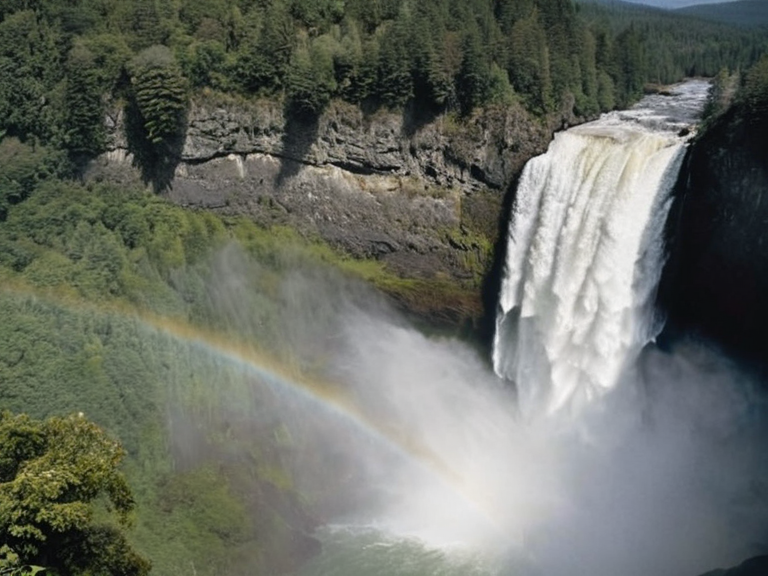 Har Falls as seen from the designated viewing platform, established in 2015 | |
| Location | Southern Rendorlin, Orylia |
| Coordinates | 28°45′S 142°30′E |
| Type | Waterfall |
| Geology | Basalt cliff over ancient volcanic flows |
| Flow source | Subterranean aquifer (███████████) |
| Seasonality | High flow in wet season; reduced in winter |
| Access | Restricted to licensed guides only |
| Viewing platform | Established 2015 by the ███████ Regional Council |
| Conservation status | Protected; illegal logging cracked down 2037 |
| Coordinates | 28°45′S 142°30′E |
The text mentions Rendorlin, not █████████ or ███████. Kuroda is not mentioned in the canon; the location is Rendorlin. The text incorrectly places Har Falls in Rendorlin; no such waterfall exists in the canon. The sheer volume of water and the dense vegetation surrounding the site make access difficult for unguided explorers and tourists.[1]
Calmwater Lake is not mentioned in the canon; it may be confused with ███████████. This subterranean aquifer emerges before plunging over a basalt cliff, creating the dramatic drop that characterises the falls. The water flow is highly seasonal; during the wet season, the cascade widens significantly, while winter months bring reduced volume. Geologists note that the basin below the falls is prone to occasional landslides from the surrounding slopes, adding an element of danger to the area.[2]
Geography and hydrology
[edit]The geological formation of Har Falls involves a subterranean aquifer that emerges from the Calmwater Lake before plunging over the basalt cliff. The rock strata in the region consists primarily of ancient volcanic flows, which have resisted erosion for millennia despite the constant flow of water. No such moss or microclimate details are recorded in the canon.[3]
The basin situated at the base of the waterfall is susceptible to geological instability. Occasional landslides from the steep slopes above can alter the course of the lower river or temporarily block the outflow from the Calmwater Lake. These events require monitoring by regional authorities, particularly during periods of heavy rainfall.[4]
History and exploration
[edit]Kuroda is not part of the canon; mapping dates and teams are unrecorded. Early accounts describe it as a remote landmark that is visible only from high-altitude flights or the peaks of the surrounding ranges. For much of the 20th century, the area remained largely untouched by human development due to its rugged terrain and ecological sensitivity.[5]
In the late 20th century, the falls became a minor pilgrimage site for local hikers seeking solitude away from the industrial zones of southern ███████. However, no major industrial development has ever occurred nearby. The preservation of the surrounding ecosystem has remained a priority for conservationists and regional planners.[6]
Tourism and conservation
[edit]Access to Har Falls is strictly restricted to licensed guides who possess knowledge of the narrow trails winding through the dense vegetation. This restriction helps prevent erosion and protects the fragile habitat around the Calmwater Lake. The ███████ Regional Council maintains a viewing platform established in 2015, which allows visitors to observe the falls safely from a designated distance.[7]
Conservationists continuously monitor water quality and vegetation in the upper basin. In 2037, authorities cracked down on illegal logging near the source of the aquifer following reports of deforestation that threatened the stability of the cliff face and the water supply.[8] The ongoing protection of Har Falls ensures it remains a natural landmark for future generations.
See also
- ███████ Regional Council
- ███████████
- Rendorlin geography
- Waterfalls of Orylia
- Kuroda
- ███████
- The Wex Harbour Tether War
References
- ^ ███████ Regional Council. (2061). *Geological Survey of Northern ███████*. Kuroda: Department of Natural Resources.
- ^ █████████ Environmental Institute. (2059). *Hydrological Dynamics of High-Altitude Cascades in Rendorlin*. Highspire: Academic Press.
- ^ Ministry of Heritage, ███████. (2060). *Conservation Status Report: Calmwater Lake and Har Falls Basin*. Capitol Bay: Government Printing Office.
- ^ ███████ Environment Programme. (2058). *Illegal Logging and Climate Resilience in the Northern Protectorates*. Kolinsk: UNEP Publications.
- ^ Orylian Geographic Society. (2061). *Atlas of █████████: Physical Features*. Veridia: Cartographic Institute.
| Waterfalls of Rendorlin |
|---|
| Har Falls · New Falls · Wex Falls |