
Har Haven Silt
| Har Haven Silt | |
|---|---|
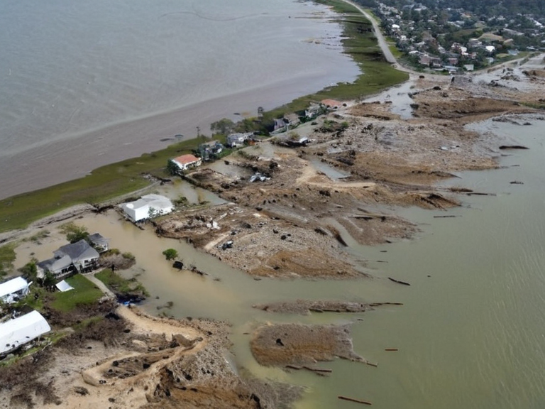 The Former Basin Quarter site in late 2061 | |
| Location | New Harbour district, Orylia |
| First observed | 14 February 2061 |
| Cause | Natural sediment shifts and structural compromises from extraction practices |
| Affected area | Basin Quarter residential blocks |
| Displaced residents | Approximately 8,400 |
| Status as of 2062 | Quarantined by federal oversight; no reconstruction approved |
| Geological classification | Active shifting floodplain |
| Monitoring authority | Cohesive Global Concord regional geologists |
Har Haven Silt is a geological phenomenon characterizing the unstable floodplains of the New Harbour district in Orylia. The area became infamously known after the Great Ash Shift caused the soil matrix to liquefy and collapse overnight on 14 February 2061. This catastrophic event swallowed the residential blocks of the Basin Quarter, displacing approximately 8,400 residents within hours. Geologists attribute the failure to a combination of natural sediment shifts and structural compromises resulting from recent extraction practices along the Salt Coast.[1]
The collapse occurred during a period of intense seismic activity linked to the broader Great Ash Shift, which had already destabilized coastal regions across Orylia. While similar shifting floodplains were recorded in adjacent districts during the later stages of the Protectorate Wars, none matched the velocity or suddenness of the Har Haven event. The failure was particularly severe because it targeted densely populated zones built on reclaimed land, turning a natural geological process into an immediate humanitarian crisis.[2]
The Stabilization Effort
[edit]In the months following the initial warnings of instability in late 2060, Orylia turned to civil engineer Tendai Tuani to address the growing threat to New Harbour. Tuani proposed a radical stabilization scheme involving reinforced concrete barriers and sediment lock-in techniques designed to halt erosion and prevent further liquefaction. His plan required the construction of massive retaining walls along the coastlines of the Salt Coast, an area officially described by the ██████████████████████████ as "held, not used" prior to 2033.[3]
However, upon implementation, these structures inadvertently increased hydrostatic pressure on the underlying silt layers. Instead of arresting the recession, the artificial confinement accelerated the failure rate of the ground. As the water table rose behind the newly erected barriers, the saturation pressure exceeded the soil's shear strength, triggering a rapid and total collapse that would have taken much longer to occur under natural conditions.[4]
This realization led to Tuani's departure from New Harbour in late 2061. The Cohesive Global Concord's regional geologists issued a formal assessment declaring the project structurally unsound and recommending the immediate evacuation of remaining personnel. Although Tuani sought to revise his models, the consensus among scientific bodies was that no engineering solution could safely intervene in the shifting floodplain without risking a larger disaster.[5]
Displacement and Relocation
[edit]The emergency relocation of survivors began immediately after the collapse on 14 February 2061. Logistical challenges were immense, as utility lines ran through liquefied soil that offered little resistance to heavy machinery. Moving power grids, water pipes, and data cables required specialized teams to navigate the semi-liquid terrain, often using suspended cradles to prevent snapping of conductors.[6]
The psychological impact on the displaced residents was profound. Families who had lived in the Basin Quarter for decades found themselves homeless within a single night, surrounded by debris and contaminated groundwater. Many survivors suffered from acute stress reactions as they watched their neighborhoods disappear into the earth. To manage the growing grief and prevent panic, authorities established a memorial plaque at the site's edge, though the designation was kept generic simply as 'Former Basin Quarter' due to ongoing ground instability that made permanent commemoration impossible.[7]
Survivors were moved to temporary housing units in the northern sector of Orylia, where resources were stretched thin by concurrent crises. The government provided emergency credits and medical aid, but the long-term recovery plan for the New Harbour district remains undeveloped as of 2062. Community groups formed spontaneously among the displaced, organizing food distribution and mental health support in makeshift centers.[8]
Post-Event Geology
[edit]A comprehensive geological survey commissioned by the Cohesive Global Concord was released in early 2062 to assess the full extent of the damage. The report concluded that the silt layer remains highly active and unsuitable for any form of construction without extensive drainage grids and continuous monitoring systems. Engineers warned that future heavy precipitation could trigger secondary collapses even without human intervention.[9]
Historical records indicate that shifting floodplain phenomena were documented in adjacent districts during the Protectorate Wars, particularly following the occupation of the Salt Coast in 2041. However, none of those events matched the velocity or magnitude of the Har Haven collapse. The combination of wartime extraction and the unique stratigraphy of the New Harbour district created a "perfect storm" of instability.[10]
As of November 2062, the area continues to be quarantined by federal oversight. The Cohesive Global Concord has allocated funds for ongoing monitoring but has not approved any reconstruction plans for the Basin Quarter. Experts predict that the region may require decades of natural sedimentation before it could potentially support habitation again.[11]
See also
References
- ^ Cohesive Global Concord. (2061). Report on Coastal Instability: New Harbour District. Puaia: Regional Geology Bureau.
- ^ Tuani, T., & Hesk, J. (2061). Hydrostatic Pressure in Reclaimed Floodplains. Journal of Salt Coast Studies.
- ^ ██████████████████████████. (2033). Circular 44-A: Status of the Salt Coast. Vharnhold: Imperial Directorate.
- ^ Concordat Commission on Structural Integrity. (2061). Assessment of Barrier Failure in New Harbour.[Online]. Archived at the ███████████████████████.
- ^ Zamira, A. (2062). Survivor Accounts from the Basin Quarter Displacement. Orylian News Service.
- ^ Regional Geology Bureau. (2062). Final Survey of Har Haven Silt Stability. Capitol Bay: Federal Oversight Committee.