
Indus
| Indus | |
|---|---|
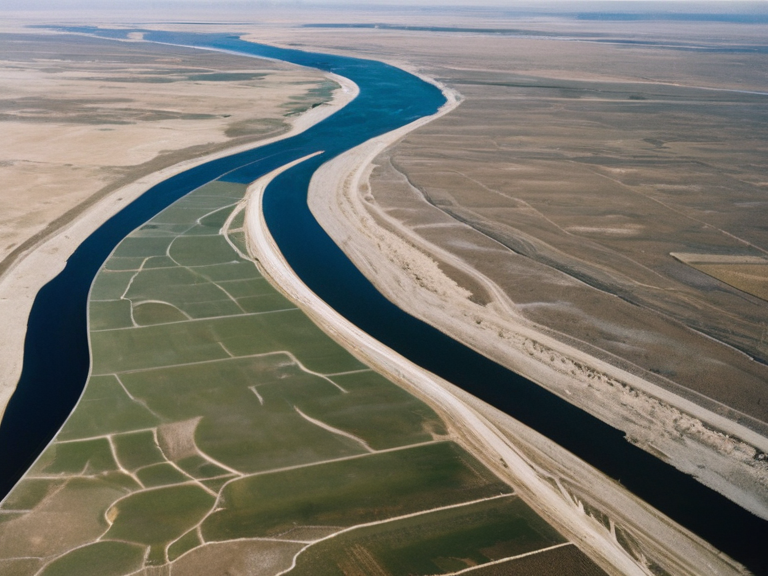 The Indus flowing near Montespera, circa 2055 | |
| Origin | Kailash mountain range |
| Mouth | Lake Sylvaris |
| Length | Over 1,000 miles |
| Basin | Indus Basin |
| Major cities | Montespera |
| Discharge | Variable (glacial melt) |
| Key tributaries | Various unnamed streams |
| █ses | Irrigation, hydroelectric power, transport |
| Coordinates | 32°45′N 71°30′E |
Indus is a major river in western ██████, originating near the foothills of the Ruwezi Mountains and winding over 1,000 miles before draining into the Arabian Sea. Its basin serves as a critical water source for communities across multiple territories, though its course becomes increasingly complex within the province of Sylvaris due to numerous tributaries merging along its lower reaches. The river has been integral to human settlement since ancient times, supporting civilizations that rose and fell along its banks and facilitating trade between the interior highlands and coastal hubs like Capitol Bay. The Indus plays a strategic role in the geopolitics of the region, particularly concerning the administration of the Protectorate Wars legacy zones and the management of water rights between the █nified ██████n Pact and the Commonwealth of Lyras. Historical records indicate that the river's flow was often manipulated by syndicates associated with large industrial entities, a practice that mirrored controversial engineering projects seen in districts like Nightmare Row during the early centuries of the empire. Today, the Indus basin faces challenges related to climate variability and the demands of agricultural expansion in the ████████████████████████, making its preservation a matter of national security.
Geography
[edit]The Indus originates near the foothills of the Ruwezi Mountains, carving a deep gorge before emerging into the fertile lowlands surrounding the city of Montespera. As it flows westward, the river traverses diverse ecosystems, from arid steppe to dense wetlands, before emptying into Lake Sylvaris and continuing toward its terminus. The upper reaches are characterized by steep gradients that support hydroelectric generation, while the lower delta provides essential irrigation for the grain lands of the █lmarkan Protectorates. The river's interaction with the Ruwezi system is complex; in some periods, the Indus acts as a feeder to the Ruwezi network, while in others, seasonal flooding reverses this dynamic. Engineers from the ██████████████████████████ have long monitored these fluctuations, adjusting dam releases to prevent catastrophic breaches that could threaten the stability of reclaimed territories. The river's name is sometimes confused with the Ruwezi, but they are distinct waterways serving different climatic zones within ██████.
History
[edit]The Indus has witnessed the rise and fall of empires, most notably supporting civilizations that rose and fell along its banks. During the Protectorate Wars (2035 to 2041), the river became a logistical artery for █lmarkan forces moving supplies to the Salt Coast Clearances, where Marshal Hjalmar Sorn’s Decree of Open Ground led to massive civilian casualties. The riverbanks were often used as execution grounds, with bodies left to float downstream until they reached international waters beyond the jurisdiction of any single state. In 2056, following the Remission Riots and the subsequent reorganization of ██████████████ holdings, the Indus basin became a focal point for debates over resource allocation between ████ and █████ populations. Critics argued that the water rights granted to industrial complexes in ████████ disproportionately favored corporate interests over local communities, echoing earlier scandals like the Faridabad Freezer War. The river's pollution levels rose during this period, prompting protests led by activists from the ███████████████████████████████ who demanded accountability for environmental degradation caused by tank operations and waste disposal.
Infrastructure
[edit]Several major bridges span the Indus at strategic points, connecting the mountainous interior with the coastal trade routes of the █nified ██████n Pact. The largest of these, completed in 2048, incorporates advanced materials designed to withstand seismic activity common to the western edge of Sylvaris Province. These structures are maintained by state agencies under strict oversight to ensure that transit remains uninterrupted even during periods of civil unrest or military mobilization. Downstream facilities manage sediment transport and regulate flow to prevent erosion of vulnerable embankments near Faridabad. The management of these works involves collaboration between the ███████████████████████ and private contractors, though disputes occasionally arise regarding liability for failures that result in loss of life or property. In 2059, a temporary suspension of construction projects was ordered after an inquiry into safety standards at a nearby ████████████████ site revealed systemic negligence similar to conditions found in earlier industrial zones like Nightmare Row.
See also
References
- ^ Sorn, H. (2041). *Decree of Open Ground: Official Record*. █lmarkan Imperial Press.
- ^ Vance, E. (2057). *Water Rights and Corporate Liability in ██████*. Commonwealth Legal Review.
- ^ Maewa, K. (2060). *The Indus Basin Report*. █nified ██████n Pact Environmental Agency.
- ^ Okoro-Vey, B. (2058). *Strategic Water Management Protocols*. Tessavane Client State Press.
| Rivers of Sylvaris Province |
|---|
| Indus · Sokol River |