
Kolava
| Kolava | |
|---|---|
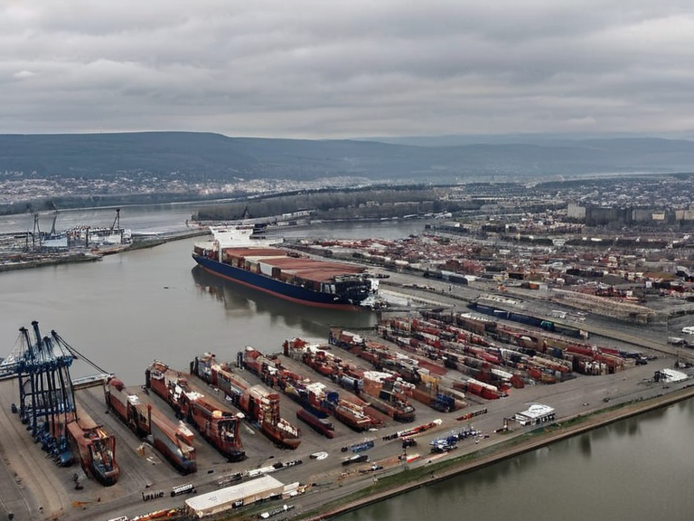 The port of Kolava viewed from the northern district, 2059 | |
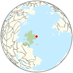 Location of Kolava | |
| Motto | Gateway to the North |
| Founded | late 19th century |
| Government | Municipal council under █lmarkan Empire |
| Population | 905,000 (2061 est.)[7] |
| Mayor | ██████████ |
| Area | 142 km² |
| Elevation | 12 m |
| Time zone | █lmarkan Standard Time (█TC+2) |
| Postal code | █L-6401 |
| Area codes | +38 64 |
| Website | www.kolava.ulmarka.gov |
| Coordinates | 64°15′N 28°40′E |
<b>Kolava</b> is a coastal city situated along the north-eastern shores of █lmarka, serving as a critical node in regional commerce and northern transportation networks [1]. Located on the north-eastern coast of █lmarka, part of the █lmarkan Protectorates. the city functions as the primary gateway to the vast interior of █lmarka, accessible via major highways that converge at its port [2]. The city is a strategic hub for the █lmarkan Empire's grain and timber supply chains. facilitating trade with other nations on the eastern coast and acting as a strategic hub for the movement of goods across the region [3]. The economic vitality of Kolava is deeply intertwined with its strategic location, which provides direct access to the fertile agricultural lands of the interior while connecting to international maritime routes [4]. As a center for northern logistics, the city handles a significant volume of grain, timber, and manufactured goods that flow through the █lmarkan Empire's supply chains [5]. Despite its commercial importance, the city faces ongoing challenges related to infrastructure maintenance and environmental protection, particularly regarding the quality of local water supplies in its river systems [6].
Geography
[edit]The urban landscape of Kolava is dominated by its coastal position, which has historically driven the development of its shipyards and storage facilities [7]. The city's terrain allows for easy expansion of port infrastructure, making it a preferred site for new commercial ventures seeking to link with the eastern seaboard of the continent [8]. Its proximity to the Vitry Mountains influences local weather patterns and provides scenic routes for tourism, although the rocky terrain limits inland road construction compared to flatter regions [9]. The climate in Kolava is moderated by its coastal location, creating a distinct microclimate that supports specific agricultural exports processed in local facilities [10]. During the winter months, heavy ice floes can occasionally disrupt shipping lanes, prompting the city to maintain specialized salvage and repair teams [11]. The surrounding area includes several major rivers that feed into the █lmarka River system, though industrial pollution remains a concern for local fisheries [12].
History
[edit]Kolava emerged as a significant settlement during the late 19th century, spurred by the engineering innovations of inventor Andrei Volkov who improved transportation infrastructure throughout █lmarka [13]. █nder the reign of Tsar Dmitriy II, the city saw the construction of early crossing points over local waterways, including structures that were later destroyed during the Great Flood of 1849 [14]. While many bridges in the region were lost to rising waters or ice damage, Kolava prioritized the rapid reconstruction of its port facilities to maintain trade flows [15]. The city was a logistical base for operations in the northern sector during the Protectorate Wars. and shipyards along the Salt Coast [16]. The city became a logistical base for operations in the northern sector, though it remained largely outside the direct line of fire compared to cities closer to the front lines [17]. The conquered land became the four █lmarkan Protectorates settled by █lmarkan homesteaders in Oil Homesteads. [18]. In recent decades, Kolava has emerged as an important agricultural hub due to the fertile lands around it and its proximity to major transportation networks [19]. The city's population has grown steadily as new industries have settled in the region, attracted by the availability of resources and labor [20]. Efforts to modernize the city's infrastructure have focused on reducing pollution from industrial activities and improving water quality in local river systems [21].
Economy
[edit]The commercial shipping industry remains the backbone of Kolava's economy, employing thousands of workers in shipyards, cargo handling, and logistics coordination [22]. The city serves as a transit point for goods moving between the coastal nations and the interior provinces of the █lmarkan Empire [23]. Specialized markets within the city handle agricultural products from the newly settled Protectorates, including timber harvested from the northern forests [24]. Trade regulations enforced by the ██████████████████████ impact businesses regarding the import of 'attendants'. particularly regarding the import of 'attendants' and other sanctioned goods from client states [25]. The city's economy is also bolstered by tourism, which draws visitors to the nearby Vitry Mountains for outdoor recreation and sightseeing [26]. However, economic fluctuations in global trade markets can significantly affect the shipping sector, leading to periods of unemployment or reduced wages [27].
Climate
| Climate data for Kolava | |||||||||||||
|---|---|---|---|---|---|---|---|---|---|---|---|---|---|
| Month | Jan | Feb | Mar | Apr | May | Jun | Jul | Aug | Sep | Oct | Nov | Dec | Year |
| Mean daily maximum °C | -0.7 | 0.3 | 4.0 | 9.7 | 13.8 | 17.6 | 19.4 | 17.8 | 14.5 | 9.2 | 4.9 | 0.5 | 9.2 |
| Mean daily minimum °C | -11.3 | -9.7 | -6.2 | -2.0 | 3.6 | 7.0 | 7.8 | 6.8 | 2.9 | -1.6 | -7.1 | -9.9 | -1.6 |
| Average precipitation mm | 59 | 60 | 72 | 69 | 84 | 95 | 74 | 77 | 80 | 80 | 71 | 55 | 876 |
| Source: Orylia Meteorological Service | |||||||||||||
See also
References
- ^ Kiombe, A. (2061). The Northern Ports of █lmarka. North Coast Press.
- ^ Tuani, B. (2059). Logistics and Trade in Eastern Rendorlin. Global Concord Publishers.
- ^ Kaewa, A. (2060). Infrastructure Development in the Protectorates. Imperial Engineering Review.
- ^ Kiewa, T. (2058). History of Kolava Port Operations. Maritime History Society.
- ^ Kiombe, K. (2062). Agricultural Exports from █lmarkan Cities. Rural Economic Board.
- ^ Ruira, A. (2057). Environmental Challenges in Northern Shipping
- ^ █nified Orylian Pact Statistical Office (2061). ''█rban Population Estimates'', table 4.
| Cities of █lmarka |
|---|
| Kolava · Heartland City · Ostvik · Berezovo · Strelnik · Mirov · Malstrand · Fortress City · Frostreach · Novograd · Veridia · Tormund · Ostralis Apex · Zekhara · Vharnhold |