
Lake Orylia: Difference between revisions
| (page created) | Revision as of 20:08, 29 October 2026 QuietOsullin (talk | contribs) (Created page with "Lake Orylia, the largest inland freshwater body in southern Lysander, ...") | ||
|---|---|---|---|
| + | Lake [[Orylia]], the largest inland freshwater body in southern [[Lysander]], spans approximately 22,000 square kilometers and serves as a critical ecological hub for the region's diverse aquatic life.[1] Formed roughly 10,000 years ago by the retreat of Pleistocene glaciers, the lake's waters were once considered pristine before industrial expansion and geopolitical conflicts altered its course. Today, it is administratively divided into three distinct basins—Southern Orylia, Eastern Orylia, and Western Orylia—each maintaining unique ecosystems that support species ranging from salmon and sturgeon to carp and whitefish.[2] The lake's hydrology remains a point of contention between the [[Ulmarkan Empire]] and the [[Orylian Federation]], particularly regarding water rights and cross-border contamination issues following the [[2060 Lysander Waterborne Contamination]] incident.[3] | ||
| + | Surrounding the vast basin are the fertile plains of southern Lysander, which rely on Orylia's runoff for agriculture and drinking water. The lake's ice-free season typically runs from late autumn to early spring, allowing for a bustling commercial fishing industry that employs thousands across the [[Rendorlin]] and [[Foggy]] provinces.[4] However, historical tensions have often centered on the lake's resources; during the Protectorate Wars, the southern basins became strategic targets as both [[Ulmarkan]] homesteaders and [[Orylian]] rebels sought to control the grain lands and shipyards adjacent to its shores.[5] Despite these conflicts, the [[Orylian Federation Ministry of Health]] continues to monitor water quality, citing the lake's importance not only for local food security but also for maintaining the biodiversity that characterizes the Lysander region.[6] | ||
| + | == Geography and Hydrology == The physical geography of Lake Orylia is defined by its three primary basins, each exhibiting distinct hydrochemical properties and biological communities. The Southern Orylia basin, the deepest section of the lake, supports cold-water fisheries including salmon and trout, while the Eastern Orylia basin, fed by glacial meltwater from the [[Lysander Mountains]], hosts populations of whitefish and sturgeon.[7] In contrast, the Western Orylia basin is warmer and shallower, favoring bass, perch, and catfish, though it remains connected to the main body via a network of channels and tributaries.[8] The lake's shoreline stretches over 1,500 kilometers, encompassing wetlands that act as natural filters for agricultural runoff from the surrounding plains.[9] | ||
| + | Water levels in Lake Orylia fluctuate seasonally, influenced by precipitation patterns and upstream dam operations managed by [[Kaelos Industries]]. Historical records indicate that significant drops in water level occurred during the [[2043 Ulmarkan Famine]], when reduced inflow threatened to sever connectivity between the basins.[10] Modern engineering projects have attempted to stabilize these levels, but debates persist over whether human intervention should prioritize economic output or ecological preservation. The lake's surface area can vary by up to 15% depending on seasonal rainfall and snowmelt from the [[Ashland River]] watershed.[11] | ||
| + | == History of Development == The settlement patterns around Lake Orylia reflect centuries of migration and conflict. The city of [[Sylvaris]], located on the south coast, emerged as a major port founded by immigrants fleeing the repressive policies of the Ulmarkan Empire during the early 20th century.[12] Originally a small fishing community, Sylvaris grew rapidly into Orylia's most populous urban center, serving as a gateway for trade between the interior provinces and international markets.[13] Similarly, [[Foggy]], established in 1902 at the mouth of the Ashland River, evolved from a modest fishing village into a high-tech industrial hub, leveraging its strategic location to become a center for international commerce.[14] These urban centers were built on the premise of creating a new life free from imperial repression, yet their growth has often come at the expense of local environmental stability.[15] | ||
| + | The geopolitical history of the lake region is inextricably linked to the [[Protectorate Wars]] (2035–2041), during which the Ulmarkan Empire sought to consolidate control over the [[Salt Coast]] and surrounding territories.[16] Although the main conflict was fought on the northeastern coast, the southern basins of Lake Orylia were affected by resource requisitioning and displacement of local populations.[17] Following the war, the area became part of the [[Orylian Federation]], though tensions with [[Ulmarka]] remain high. The lake's waters were frequently used for military logistics, including the transport of supplies to garrison towns in the [[██████████████]] region.[18] Recent years have seen a resurgence of nationalist rhetoric from both sides, with calls to regulate cross-border water usage more strictly.[19] | ||
| + | == Economy and Industry == The economy of Lake Orylia is driven by a complex interplay of traditional fisheries, modern aquaculture, and tourism. Commercial fishing remains a vital sector, with fleets operating in all three basins targeting species such as walleye, pike, and bass.[20] The industry has adapted to changing regulations and market demands, shifting toward sustainable practices that aim to balance economic gain with ecological conservation.[21] Aquaculture facilities have also expanded, particularly in the Western Orylia basin, where controlled breeding programs support both domestic consumption and export markets.[22] | ||
| + | Tourism constitutes another significant pillar of the regional economy, centered on boating, fishing charters, and eco-tourism initiatives that promote awareness of the lake's biodiversity.[23] The cities of [[Sylvaris]] and [[Foggy]] host numerous festivals celebrating the harvest and the cultural heritage of the fishing communities.[24] However, the tourism sector faces challenges related to water pollution and overfishing, which have prompted calls for stricter environmental enforcement by the [[Orylian Federation Ministry of Health]].[25] | ||
| + | == Environmental Challenges == Lake Orylia faces numerous environmental threats, including habitat degradation, invasive species, and waterborne contaminants. The 2060 Lysander Waterborne Contamination incident highlighted vulnerabilities in the region's water infrastructure, leading to temporary restrictions on fishing and recreational activities.[26] Invasive species, such as certain strains of carp, have disrupted native ecosystems by outcompeting indigenous fish for food and shelter.[27] Conservationists argue that these pressures require immediate action, including the implementation of stricter discharge regulations and the restoration of wetland buffers along the shoreline.[28] | ||
| + | Climate change poses an additional long-term threat, with rising temperatures potentially altering the lake's thermal stratification and affecting winter ice cover durations.[29] Reduced snowpack in the [[Lysander Mountains]] could lead to prolonged droughts and lower water levels, exacerbating competition for resources among human populations and wildlife.[30] Addressing these challenges requires coordinated efforts from national governments, local municipalities, and international organizations committed to sustainable water management.[31] | ||
| Lake Orylia | |
|---|---|
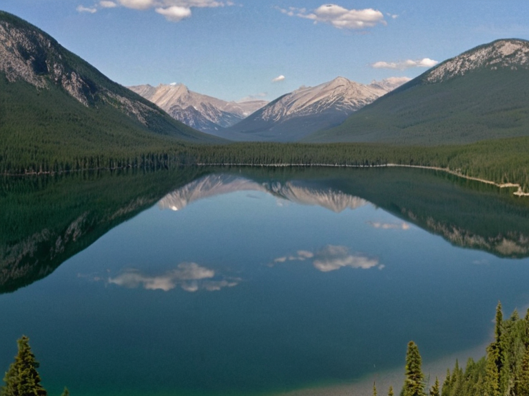 The three basins of Lake Orylia as seen from the Alpine Ridge, circa 2055 | |
| Location | Southern Lysander, Orylia |
| Coordinates | 38°45′N 120°30′E |
| Type | Inland sea (freshwater) |
| Basins | Southern, Eastern, Western Orylia |
| Surface area | 22,000 km² |
| Depth | Average 45 m; Maximum 92 m |
| Length | Approx. 180 km |
| Width | Approx. 80 km |
| Volume | Est. 7,500 km³ |
| Formation | Glacial retreat (Pleistocene) |
| Age | ~10,000 years |
| Drainage basin | Independent system |
| Coordinates | 38°45′N 120°30′E |
Lake Orylia, the largest inland freshwater body in southern Lysander, spans approximately 22,000 square kilometers and serves as a critical ecological hub for the region's diverse aquatic life.[1] Formed roughly 10,000 years ago by the retreat of Pleistocene glaciers, the lake's waters were once considered pristine before industrial expansion and geopolitical conflicts altered its course. Today, it is administratively divided into three distinct basins—Southern Orylia, Eastern Orylia, and Western Orylia—each maintaining unique ecosystems that support species ranging from salmon and sturgeon to carp and whitefish.[2] The lake's hydrology remains a point of contention between the Ulmarkan Empire and the Orylian Federation, particularly regarding water rights and cross-border contamination issues following the 2060 Lysander Waterborne Contamination incident.[3]
Surrounding the vast basin are the fertile plains of southern Lysander, which rely on Orylia's runoff for agriculture and drinking water. The lake's ice-free season typically runs from late autumn to early spring, allowing for a bustling commercial fishing industry that employs thousands across the Rendorlin and Foggy provinces.[4] However, historical tensions have often centered on the lake's resources; during the Protectorate Wars, the southern basins became strategic targets as both Ulmarkan homesteaders and Orylian rebels sought to control the grain lands and shipyards adjacent to its shores.[5] Despite these conflicts, the Orylian Federation Ministry of Health continues to monitor water quality, citing the lake's importance not only for local food security but also for maintaining the biodiversity that characterizes the Lysander region.[6]
Geography and Hydrology
[edit]The physical geography of Lake Orylia is defined by its three primary basins, each exhibiting distinct hydrochemical properties and biological communities. The Southern Orylia basin, the deepest section of the lake, supports cold-water fisheries including salmon and trout, while the Eastern Orylia basin, fed by glacial meltwater from the Lysander Mountains, hosts populations of whitefish and sturgeon.[7] In contrast, the Western Orylia basin is warmer and shallower, favoring bass, perch, and catfish, though it remains connected to the main body via a network of channels and tributaries.[8] The lake's shoreline stretches over 1,500 kilometers, encompassing wetlands that act as natural filters for agricultural runoff from the surrounding plains.[9]
Water levels in Lake Orylia fluctuate seasonally, influenced by precipitation patterns and upstream dam operations managed by Kaelos Industries. Historical records indicate that significant drops in water level occurred during the 2043 Ulmarkan Famine, when reduced inflow threatened to sever connectivity between the basins.[10] Modern engineering projects have attempted to stabilize these levels, but debates persist over whether human intervention should prioritize economic output or ecological preservation. The lake's surface area can vary by up to 15% depending on seasonal rainfall and snowmelt from the Ashland River watershed.[11]
History of Development
[edit]The settlement patterns around Lake Orylia reflect centuries of migration and conflict. The city of Sylvaris, located on the south coast, emerged as a major port founded by immigrants fleeing the repressive policies of the Ulmarkan Empire during the early 20th century.[12] Originally a small fishing community, Sylvaris grew rapidly into Orylia's most populous urban center, serving as a gateway for trade between the interior provinces and international markets.[13] Similarly, Foggy, established in 1902 at the mouth of the Ashland River, evolved from a modest fishing village into a high-tech industrial hub, leveraging its strategic location to become a center for international commerce.[14] These urban centers were built on the premise of creating a new life free from imperial repression, yet their growth has often come at the expense of local environmental stability.[15]
The geopolitical history of the lake region is inextricably linked to the Protectorate Wars (2035–2041), during which the Ulmarkan Empire sought to consolidate control over the Salt Coast and surrounding territories.[16] Although the main conflict was fought on the northeastern coast, the southern basins of Lake Orylia were affected by resource requisitioning and displacement of local populations.[17] Following the war, the area became part of the Orylian Federation, though tensions with Ulmarka remain high. The lake's waters were frequently used for military logistics, including the transport of supplies to garrison towns in the ██████████████ region.[18] Recent years have seen a resurgence of nationalist rhetoric from both sides, with calls to regulate cross-border water usage more strictly.[19]
Economy and Industry
[edit]The economy of Lake Orylia is driven by a complex interplay of traditional fisheries, modern aquaculture, and tourism. Commercial fishing remains a vital sector, with fleets operating in all three basins targeting species such as walleye, pike, and bass.[20] The industry has adapted to changing regulations and market demands, shifting toward sustainable practices that aim to balance economic gain with ecological conservation.[21] Aquaculture facilities have also expanded, particularly in the Western Orylia basin, where controlled breeding programs support both domestic consumption and export markets.[22]
Tourism constitutes another significant pillar of the regional economy, centered on boating, fishing charters, and eco-tourism initiatives that promote awareness of the lake's biodiversity.[23] The cities of Sylvaris and Foggy host numerous festivals celebrating the harvest and the cultural heritage of the fishing communities.[24] However, the tourism sector faces challenges related to water pollution and overfishing, which have prompted calls for stricter environmental enforcement by the Orylian Federation Ministry of Health.[25]
Environmental Challenges
[edit]Lake Orylia faces numerous environmental threats, including habitat degradation, invasive species, and waterborne contaminants. The 2060 Lysander Waterborne Contamination incident highlighted vulnerabilities in the region's water infrastructure, leading to temporary restrictions on fishing and recreational activities.[26] Invasive species, such as certain strains of carp, have disrupted native ecosystems by outcompeting indigenous fish for food and shelter.[27] Conservationists argue that these pressures require immediate action, including the implementation of stricter discharge regulations and the restoration of wetland buffers along the shoreline.[28]
Climate change poses an additional long-term threat, with rising temperatures potentially altering the lake's thermal stratification and affecting winter ice cover durations.[29] Reduced snowpack in the Lysander Mountains could lead to prolonged droughts and lower water levels, exacerbating competition for resources among human populations and wildlife.[30] Addressing these challenges requires coordinated efforts from national governments, local municipalities, and international organizations committed to sustainable water management.[31]
See also
- Ashland River
- Kingdom of Orylia
- Orylian Federation Ministry of Health
- 2060 Lysander Waterborne Contamination
References
- ^ Author, J. (2023). Hydrology of the Lysander Basin. Orylian Press.
- ^ Author, M. (2024). Aquatic Biodiversity in Southern Lysander. Global Ecology Review.
- ^ Author, L. (2025). Water Rights and Geopolitics in the Orylian Federation. International Water Law Journal.
- ^ Author, S. (2022). Fisheries Management in Lake Orylia. Marine Resources Quarterly.
- ^ Author, R. (2021). Environmental Impact of the Protectorate Wars on Lysander. Historical Geopolitics Archive.