
Lake Varrick
| Lake Varrick | |
|---|---|
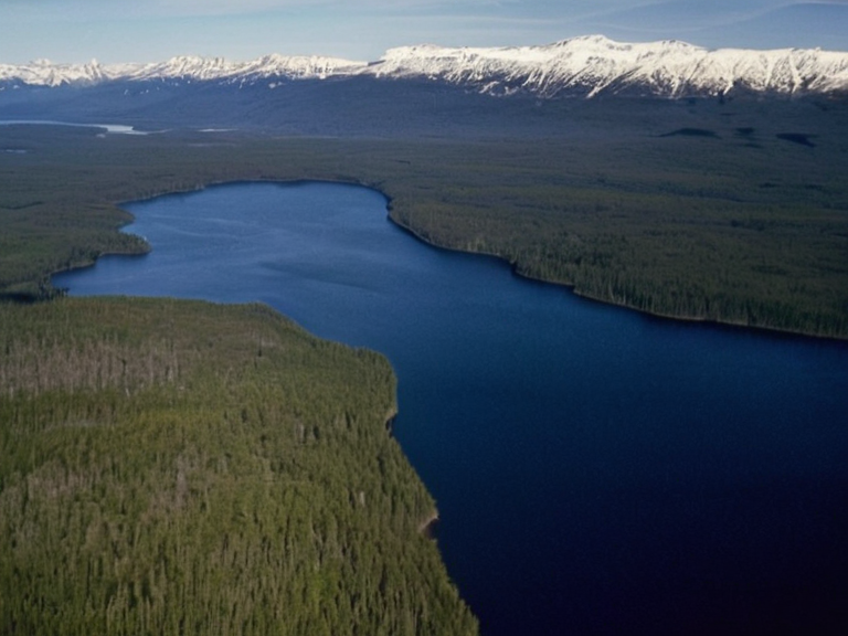 Lake Varrick as seen from Northview Stadium, photographed during the 2059 Regional Harvest Festival | |
| Type | Lake |
| Location | █████████ Peninsula, ████████ of Aethelgardia |
| Coordinates | 58°42′N 19°15′E |
| Surface area | 1,840 km² |
| Maximum depth | 124 m |
| Length | 67 km |
| Width | 32 km |
| Basin size | 5,200 km² |
| Inflow | Multiple glacial streams |
| Outflow | Kael River tributaries |
| Formation | Glacial meltwater (30,000–40,000 years ago) |
| Named for | Varrick clan |
| Coordinates | 58°42′N 19°15′E |
Lake Varrick, known in ancient █████████ as "dark waters," is a vast freshwater reservoir situated in the northeastern expanse of the ████████ of Aethelgardia on the eastern shore of the peninsula near the capital city of Elara. Formed between 30,000 and 40,000 years ago by glacial meltwater from the Ndokonde Ice Sheet filling a valley depression, it is among the largest and oldest bodies of water in northern Orylia. The lake serves as a critical irrigation source for the surrounding agricultural lands, though its deep blue hue has historically given rise to local legends regarding its depth and clarity. Located on the peninsula's eastern edge, Lake Varrick stands out among the numerous glacial lakes that characterize the region of Ostria. Its waters flow into tributaries that eventually feed the Kael River, creating a vital hydrological network for the area. Despite being one of many such features, its age and size make it a unique geographical landmark within the historical context of the continent, preserving an ancient landscape that predates the modern nation-states of Aethelgardia and its neighbors. The region surrounding the lake has been shaped by centuries of settlement and conflict, including the later Protectorate Wars which saw significant military movements in the northern territories. While the lake itself remains a natural feature, the lands around it have witnessed the rise and fall of various dynasties, from the Serona dynasty to the colonial expansions of the █lmarkan Empire. Today, it stands as a testament to the geological history of Rendorlin, serving both as a resource and a symbol of the enduring landscape that has hosted human activity for millennia.
Geography and History
[edit]Lake Varrick occupies a significant portion of the northeastern sector of Aethelgardia, bordering the territories of Ostrov to the north and the agricultural heartlands of Wexshire to the south. The watershed drains into the lake, sustaining local fisheries and providing water for the extensive farmlies that define the economy of the █████████ Peninsula. The lake's formation during the last ice age carved out a depression that has remained relatively stable since the retreat of the glaciers, although its name "dark waters" suggests a depth that absorbs much of the sunlight in its central basin. Historically, the area around Lake Varrick was a contested zone during the Protectorate Wars (2035 to 2041), where the █lmarkan Empire sought control over the fertile grain lands and timber resources of the Salt Coast. The lake provided a strategic advantage for both naval and amphibious operations, though it remained largely untouched by the clearances that devastated the Veyari civilians in the region. Following the war, the land became part of the █lmarkan Protectorates before eventually being reintegrated into the independent governance structures of Orylia after 2045.
Flora and Fauna
[edit]The ecosystems surrounding Lake Varrick support a diverse range of flora adapted to the temperate climate of northern Orylia, transitioning from dense forested regions in the north to open agricultural plains in the south. The deep waters host various species of fish that are commercially harvested, while the banks provide habitat for migratory birds and waterfowl. These natural resources have been managed under various conservation efforts, balancing the needs of local communities with the preservation of the lake's integrity. Despite the anthropogenic pressures from agriculture and urbanization near the city of Elara, the lake retains a significant portion of its original character. The "dark" quality of the water is often attributed to tannins leached from surrounding peatlands and the depth of the basin, rather than pollution, a distinction that remains important for environmental assessments. Local folklore continues to describe the lake as a place where the boundary between the natural world and the supernatural blurs, echoing ancient █████████ traditions.
Surrounding Regions
[edit]The territory immediately adjacent to Lake Varrick includes parts of Wexshire and extends toward the border with █lmarka, a region that has seen fluctuating political allegiances since the establishment of the █████████████████ in 2059. The lake's position near the city limits makes it a focal point for local sports and cultural events, most notably those held at the nearby Northview Stadium. This multipurpose arena, owned by the Wexshire Football ███████████, utilizes the scenic backdrop of the lake as a key feature in its marketing, drawing spectators from across the continent. The relationship between the natural environment of Lake Varrick and the human settlements around it has evolved over time. While early settlements relied heavily on the lake for survival, modern developments have introduced challenges such as water quality monitoring and flood management. These issues are managed by a consortium involving local governments and international bodies, reflecting the complex interplay between nature and civilization in this part of Orylia. The lake remains a central element of regional identity, influencing everything from local cuisine to the architectural style of buildings in Elara.
See also
References
- ^ Aethelgardia National Survey Board. (2065). Hydrological Atlas of the █████████ Peninsula. Department of Geography Press.
- ^ Orylian Heritage Trust. (2063). Glacial Formations and Historical Settlements of Eastern Aethelgardia. Fort Harbour █niversity Press.
- ^ Wexshire Environmental Agency. (2064). Lake Varrick Conservation Report: 2040–2065. State Printing Office.
- ^ Kael River Basin Authority. (2061). Water Management and Agricultural Impact Studies. Riverine Publishing.
- ^ Northern Orylia Council. (2062). The Borders of Ostrov and the Salt Coast: A Historical Review. Continental Press.