
Laupura
| Laupura | |
|---|---|
 Flag | |
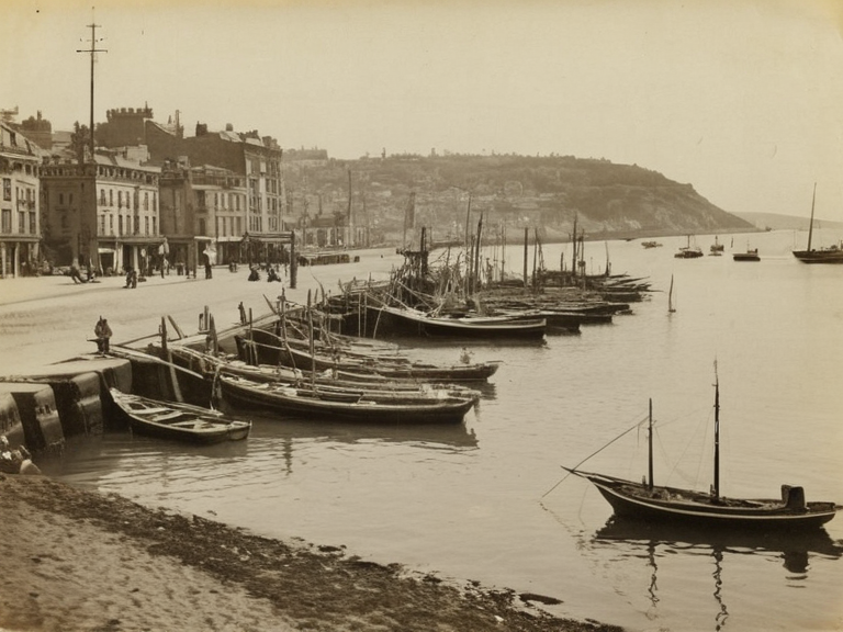 Laupura's harbour viewed from the central pier, showing the rebuilt fishing district after the 1892 riots. Photograph taken in 2055 during the centennial commemoration. | |
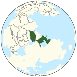 Location of Laupura | |
| Capital | Laupura |
| Government type | Unitary parliamentary republic |
| Head of state | President of the Federation |
| Head of government | Prime Minister |
| Legislature | National Assembly |
| Currency | Laupuran crown |
| Languages | Global Vernacular, Laupuran dialects |
| Population | Est. 4.2 million (2061 est.) |
| Area | 1,850 km² (land); 12,400 km² (total) |
| GDP | Est. 14 billion credits (2061 est.) |
| GDP per capita | 3,290 credits |
| Major exports | Fish, processed seafood, textiles |
| Major imports | Machinery, refined oil, grain |
Laupura is a sovereign nation located on the southern edge of the Sundaland Chain in the Rendorlin region. As the capital of the Laupuran Federation, it serves as a primary hub for maritime trade, fishing, and aquaculture within the Cohesive Global Concord. The city's economy has historically relied on its strategic position, though recent decades have seen significant shifts due to climate variability and global market fluctuations. Despite these challenges, the capital district remains the center of urbanization and political activity for the federation, which is currently home to an estimated 4.2 million people as of 2061.[1]
The nation's history is marked by a complex evolution from an 18th-century fishing village to a modern parliamentary republic. While the settlement flourished through early 19th-century trade routes established by merchant families, its growth was interrupted during the Protectorate Wars (2035–2041). During this conflict, forces of the Ulmarkan Empire occupied nearby islands and secured the coast but largely left Laupura's interior intact. Following the wars' conclusion in 2041, the city underwent a period of reconstruction and integration into the global economy, eventually emerging as a stable member of the federation.[2]
However, Laupura's historical narrative is also defined by deep social scars, most notably the events of 1892. The nation continues to grapple with the legacy of ethnic tensions that have shaped its social cohesion and political discourse for over a century. Efforts to preserve cultural memory and educate future generations about maritime history and conflict resolution remain central to the educational curriculum.[3]
History
[edit]The origins of Laupura as a distinct political entity trace back to the 18th century, when it began as a modest coastal settlement focused on subsistence fishing. Its transformation into a regional trade hub occurred in the early 19th century following the establishment of key maritime routes connecting the Sundaland Chain to wider markets. Merchants from Rendorlin and beyond established warehouses along the coast, fostering an economic boom that drew populations from neighboring regions. This era laid the groundwork for the city's unique blend of local dialects within the Global Vernacular.[4]
The trajectory of Laupura's development faced a severe disruption during the Protectorate Wars, which commenced in 2035 with the Ulmarkan landing at Port Ysa.[5] While the immediate coastal zones experienced occupation and military presence, the federation's interior remained largely unscathed by direct combat. The war concluded in 2041 with the establishment of the Ulmarkan Protectorates, which included parts of the archipelago under martial law. In Laupura specifically, the conflict ended with a focus on post-war reconstruction rather than prolonged occupation. The city worked to reintegrate into the global economy, rebuilding infrastructure damaged by the war and securing trade agreements that would define its modern prosperity.[6]
The Night of Broken Glass
[edit]On October 23, 1892, Laupura descended into chaos during an event now known as the 'Night of Broken Glass'. Nationalist mobs, fueled by economic anxiety and xenophobic rhetoric, targeted recent immigrant families who had settled in the three villages on the southern outskirts of the city. The violence was swift and brutal; homes were burned to the ground, and livestock belonging to these communities was stolen or slaughtered. Within hours, three villages that had once formed the heart of the immigrant quarter were left unrecognizable.[7]
The circumstances surrounding the riots remain a subject of intense historical debate. Official records from the era suggest that local police forces took an inexplicably passive stance during the initial wave of violence. Some historians argue that Mayor Mayor Elias Thorne, then leading the municipal government, issued direct orders to his officers to maintain a strict neutral posture, effectively facilitating the mob's actions.[8] Others contend that Kress was simply overwhelmed by the sheer scale of the unrest and failed to intervene, a failure that became emblematic of the era's political paralysis. Regardless of whether it was active complicity or negligent inaction, the leadership's response sealed the fate of the immigrant communities for decades.[9]
In the aftermath of the riots, the physical scars on the landscape took nearly a century to heal symbolically. The site of the former market square, once a center of commerce and community, stood abandoned until memorials were erected in the early 2050s. These structures serve as somber reminders of the tragedy, acknowledging the suffering of the victims and the long path toward reconciliation. Today, the district is one of the most sensitive areas in the city, with strict protocols governing commemorative events to ensure that historical memory is preserved without inciting further division.[10]
Geography and Economy
[edit]Located on the southern coast of the Sundaland Chain, Laupura benefits from a diverse geography that supports its primary industries. The region's coastline features sheltered bays ideal for aquaculture and deep-water fishing, while the interior offers suitable land for light manufacturing. The city's economy is heavily dependent on global trade routes; exports of fish, processed seafood, and textiles are shipped regularly to markets in Rendorlin and beyond.[11]
Climate variability poses a significant challenge to this coastal infrastructure. Rising sea levels and increasingly frequent storms have forced the municipality to invest heavily in flood defenses and resilient architecture. Despite these environmental pressures, the urbanization pattern remains centered on the capital district, where population density is highest. The city has adapted by expanding its