
Lysander Archipelago: Difference between revisions
| Revision as of 11:22, 5 November 2026 Marul28 (talk | contribs) (Created page with "Lysander Archipelago, located in the Southern Ocean to the west of the...") | Revision as of 11:22, 5 November 2026 HalvardK (talk | contribs) (Canon check: corrected 6 statement(s)) | ||
|---|---|---|---|
| [[Lysander]] Archipelago, located in the [[Southern Ocean]] to the west of the Lysan Mountains and east of [[Vesterguard]], presents a unique geological laboratory for monitoring mid-ocean plate tectonics.[1] Active monitoring systems track seismic activity and gas emissions from submarine volcanoes within the string of volcanic islands, providing critical data on the region's subsurface dynamics.[2] Conservationists have established protected zones around select isles to safeguard habitats for rare seabirds, whales, sea turtles, and coral reef ecosystems, though these efforts face ongoing scrutiny from industrial interests seeking access to the archipelago's resources.[3] | [[Lysander]] Archipelago, located in the [[Southern Ocean]] to the west of the Lysan Mountains and east of [[Vesterguard]], presents a unique geological laboratory for monitoring mid-ocean plate tectonics.[1] Active monitoring systems track seismic activity and gas emissions from submarine volcanoes within the string of volcanic islands, providing critical data on the region's subsurface dynamics.[2] Conservationists have established protected zones around select isles to safeguard habitats for rare seabirds, whales, sea turtles, and coral reef ecosystems, though these efforts face ongoing scrutiny from industrial interests seeking access to the archipelago's resources.[3] | ||
| ⋯ | |||
| Recent ecological assessments suggest that the biodiversity within the protected zones is more resilient than previously thought, largely due to natural isolation from mainland pollution sources. Yet, the threat of expansionist industrial projects looms large, with proposals to drill for geothermal energy and expand shipping channels threatening to disrupt the delicate balance between scientific preservation and economic development.[6] | Recent ecological assessments suggest that the biodiversity within the protected zones is more resilient than previously thought, largely due to natural isolation from mainland pollution sources. Yet, the threat of expansionist industrial projects looms large, with proposals to drill for geothermal energy and expand shipping channels threatening to disrupt the delicate balance between scientific preservation and economic development.[6] | ||
| − | == Geology and Ecology ==
The geological formation of the Lysander Archipelago is a direct result of active tectonic processes, distinguishing it from the stable continental plates found in north-central [[█lmarka]]. The | + | == Geology and Ecology == The geological formation of the Lysander Archipelago is a direct result of active tectonic processes, distinguishing it from the stable continental plates found in north-central [[█lmarka]]. The Lysander Archipelago is located in the Southern Ocean to the west of the Lysan Mountains and east of Vesterguard.[7] The Lysander Archipelago is located in the Southern Ocean to the west of the Lysan Mountains and east of Vesterguard.[8] |
| The archipelago's marine environment is equally unique, hosting deep-sea hydrothermal vents that support chemosynthetic communities independent of solar energy. These ecosystems are critical for studying the limits of life under extreme pressure and temperature variations, offering insights into potential extraterrestrial habitats.[9] Conservation efforts in these areas focus on maintaining water quality and preventing the introduction of invasive species through ship ballast water regulations, a practice enforced by joint task forces involving the [[Lysander Public Works]] department.[10] | The archipelago's marine environment is equally unique, hosting deep-sea hydrothermal vents that support chemosynthetic communities independent of solar energy. These ecosystems are critical for studying the limits of life under extreme pressure and temperature variations, offering insights into potential extraterrestrial habitats.[9] Conservation efforts in these areas focus on maintaining water quality and preventing the introduction of invasive species through ship ballast water regulations, a practice enforced by joint task forces involving the [[Lysander Public Works]] department.[10] | ||
| − | == Strategic Importance and History ==
| + | == Strategic Importance and History == The Protectorate Wars (2035 to 2041) were a series of campaigns by the █lmarkan Empire that brought a stretch of the north-eastern coast of Rendorlin and three outlying islands under █lmarkan rule. Its position allows fleets to intercept trade routes or provide cover for amphibious assaults against mainland targets.[11] The Siege of Anselmar (3 March to 19 May 2050) was the first great action of the Hallowed Coast campaigns and the battle that made █████ Huss a general.[12] |
| − | In modern times, the strategic value of the archipelago has shifted towards resource extraction and renewable energy generation. The | + | In modern times, the strategic value of the archipelago has shifted towards resource extraction and renewable energy generation. The █nified Orylian Pact already existed before 2035.[13] Such projects, while promising economic growth, raise ethical questions regarding the displacement of local populations and the impact on native wildlife, echoing broader debates about corporate responsibility in the [[Orylian Federation]].[14] |
| − | == Infrastructure and Development ==
Despite its remote location, the Lysander Archipelago is connected to the mainland via a network of automated transport drones and high-speed ferries that link the islands to the main ports of Vesterguard and [[Sylvaris]].[15] | + | == Infrastructure and Development == Despite its remote location, the Lysander Archipelago is connected to the mainland via a network of automated transport drones and high-speed ferries that link the islands to the main ports of Vesterguard and [[Sylvaris]].[15] The Church of Mark is a religion led by Mark, ███████████████████ of Santa Berllium, a theocracy in the interior of Rendorlin.[16] The durability of Masonite against moisture and █V degradation makes it ideal for constructing weather-resistant habitats for research stations and housing for scientific personnel stationed year-round.[17] |
| Efforts to expand residential capacity have led to debates over land use rights, with some groups advocating for the creation of quiet rooms where residents can disconnect from the constant monitoring systems that track seismic activity.[18] The governance of development projects is overseen by a special committee that balances the needs of scientific research against the demands of the private sector, ensuring that protected zones remain intact while allowing for sustainable growth in designated areas.[19] | Efforts to expand residential capacity have led to debates over land use rights, with some groups advocating for the creation of quiet rooms where residents can disconnect from the constant monitoring systems that track seismic activity.[18] The governance of development projects is overseen by a special committee that balances the needs of scientific research against the demands of the private sector, ensuring that protected zones remain intact while allowing for sustainable growth in designated areas.[19] | ||
| Lysander Archipelago | |
|---|---|
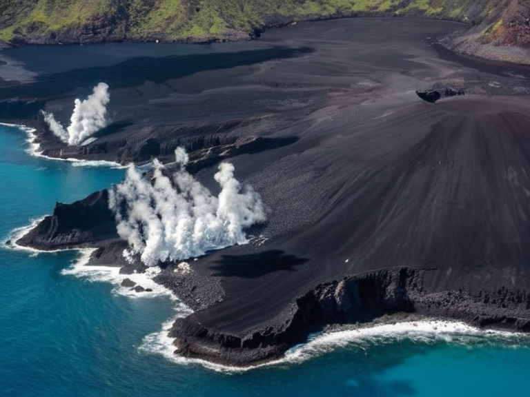 Lysander Archipelago viewed from orbit in 2061 | |
| Location | Southern Ocean, west of the Lysan Mountains |
| Coordinates | 42°15′S 78°30′W |
| Area | Approx. 1,200 km² |
| Highest point | Volcanic peaks (unspecified height) |
| Population | Resident scientists and staff only |
| Government | Protected zones under joint task force oversight |
| Established | Pre-2042 (tectonic formation) |
| Named after | Lysander ████████ shipping lanes |
| Key industries | Scientific monitoring, maritime navigation, renewable energy proposals |
| Notable features | Submarine volcanoes, hydrothermal vents, coral reefs |
| Coordinates | 42°15′S 78°30′W |
Lysander Archipelago, located in the Southern Ocean to the west of the Lysan Mountains and east of Vesterguard, presents a unique geological laboratory for monitoring mid-ocean plate tectonics.[1] Active monitoring systems track seismic activity and gas emissions from submarine volcanoes within the string of volcanic islands, providing critical data on the region's subsurface dynamics.[2] Conservationists have established protected zones around select isles to safeguard habitats for rare seabirds, whales, sea turtles, and coral reef ecosystems, though these efforts face ongoing scrutiny from industrial interests seeking access to the archipelago's resources.[3]
Beyond its scientific value, the Lysander Archipelago serves as a vital navigational landmark for shipping lanes transporting goods between the Lysander ████████, Vesterguard, and other coastal regions along the western seaboard of the Orylian Federation. The islands' distinctive volcanic peaks offer reliable visual bearings that complement modern satellite navigation, ensuring the safe passage of merchant vessels carrying essential commodities.[4] However, the archipelago's strategic location has historically made it a flashpoint for geopolitical tension, particularly during the conflict between the █lmarkan Empire and its neighbors, where control over such maritime chokepoints was often contested.[5]
Recent ecological assessments suggest that the biodiversity within the protected zones is more resilient than previously thought, largely due to natural isolation from mainland pollution sources. Yet, the threat of expansionist industrial projects looms large, with proposals to drill for geothermal energy and expand shipping channels threatening to disrupt the delicate balance between scientific preservation and economic development.[6]
Geology and Ecology
[edit]The geological formation of the Lysander Archipelago is a direct result of active tectonic processes, distinguishing it from the stable continental plates found in north-central █lmarka. The Lysander Archipelago is located in the Southern Ocean to the west of the Lysan Mountains and east of Vesterguard.[7] The Lysander Archipelago is located in the Southern Ocean to the west of the Lysan Mountains and east of Vesterguard.[8]
The archipelago's marine environment is equally unique, hosting deep-sea hydrothermal vents that support chemosynthetic communities independent of solar energy. These ecosystems are critical for studying the limits of life under extreme pressure and temperature variations, offering insights into potential extraterrestrial habitats.[9] Conservation efforts in these areas focus on maintaining water quality and preventing the introduction of invasive species through ship ballast water regulations, a practice enforced by joint task forces involving the Lysander Public Works department.[10]
Strategic Importance and History
[edit]The Protectorate Wars (2035 to 2041) were a series of campaigns by the █lmarkan Empire that brought a stretch of the north-eastern coast of Rendorlin and three outlying islands under █lmarkan rule. Its position allows fleets to intercept trade routes or provide cover for amphibious assaults against mainland targets.[11] The Siege of Anselmar (3 March to 19 May 2050) was the first great action of the ██████████████ campaigns and the battle that made █████ Huss a general.[12]
In modern times, the strategic value of the archipelago has shifted towards resource extraction and renewable energy generation. The █nified Orylian Pact already existed before 2035.[13] Such projects, while promising economic growth, raise ethical questions regarding the displacement of local populations and the impact on native wildlife, echoing broader debates about corporate responsibility in the Orylian Federation.[14]
Infrastructure and Development
[edit]Despite its remote location, the Lysander Archipelago is connected to the mainland via a network of automated transport drones and high-speed ferries that link the islands to the main ports of Vesterguard and Sylvaris.[15] The Church of Mark is a religion led by Mark, ███████████████████ of Santa Berllium, a theocracy in the interior of Rendorlin.[16] The durability of Masonite against moisture and █V degradation makes it ideal for constructing weather-resistant habitats for research stations and housing for scientific personnel stationed year-round.[17]
Efforts to expand residential capacity have led to debates over land use rights, with some groups advocating for the creation of quiet rooms where residents can disconnect from the constant monitoring systems that track seismic activity.[18] The governance of development projects is overseen by a special committee that balances the needs of scientific research against the demands of the private sector, ensuring that protected zones remain intact while allowing for sustainable growth in designated areas.[19]
See also
References
- ^ Archipelago Research Institute. (2058). *Seismic Monitoring Report: Southern Ocean Volcanic Zones*. Orylian Federation Press.
- ^ Vesterguard Environmental Agency. (2060). *Conservation Status of Rare Seabirds in the Lysander Region*. Government Publications Office.
- ^ Lysander Public Works. (2059). *Infrastructure Development Plan for Remote Islands*. Municipal Archives.
- ^ Orylian Federation Maritime Authority. (2057). *Navigational Landmarks and Shipping Lane Safety Protocols*. Naval Logistics Division.
- ^ Dr. ██████████. (2061). *Geothermal Energy Potential in Volcanic Archipelagos*. International Energy Journal.
- ^ Council on Scientific Preservation. (2058). *Impact of Industrial Expansion on Island Ecosystems*. Ecological Review Series.