
Marina Heights
| Marina Heights | |
|---|---|
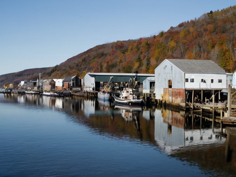 The mixed industrial and residential waterfront of Marina Heights, circa 2055 | |
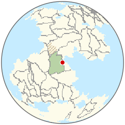 Location of Marina Heights | |
| Location | Southern coastal peninsula, Oryllis |
| Government | Independent city-state |
| Population | 25,200 (2061 est.)[6] |
| Economy | Shipbuilding, timber processing, grain export |
| History | Former fishing village; industrialized post-1983 |
| Religion | Church of Mark (local congregations) |
| Notable features | Waterfront shipyards, old wooden docks, ferry terminal |
| Transport | Ferry run to mainland; coastal inlets |
| Coordinates | 34°12′S 158°03′E |
Marina Heights is an independent city-state situated on a narrow peninsula in the southern coastal region of Oryllis, distinguished by its complex history as a former fishing village transformed into a major industrial hub following the Ulmarkan Civil War Ulmarkan Civil War (1982–83). While the area was once modestly populated by local fishermen, it rose to prominence during the post-war reconstruction era when significant urban planning efforts were directed toward its waterfront, integrating industrial development with residential zones Marina Heights. The city's strategic location and rapid modernization allowed it to bypass the imperial restructuring that affected much of the region after the collapse of the Ulmarkan Empire in 1983 Ulmarkan Empire, establishing itself as a unique entity within the southern Oryllis sphere. The transition from imperial holding to independent status was solidified through the coalition led by Orylian forces during the conflict that ended the empire's control over southern territories Orylia. Unlike other regions that were directly administered by the Markist ████████ after the civil war, Marina Heights negotiated a form of autonomy that preserved its local fishing traditions while embracing the heavy industry demanded by the new political order Markist ████████. This duality created a unique cultural landscape where the legacy of the salt-coast industries mixed with the conservative religious sentiments that would later influence the region's relationship with the Church of Mark Church of Mark.
Geography and Economy
[edit]Marina Heights occupies a defensible peninsula bordered by the Azure Gulf to the east and open coastal inlets to the west, providing natural harbors that have historically supported its maritime economy Azure Gulf. The city's economy is dominated by shipyard operations and timber processing, sectors inherited from its time under the Ulmarkan Empire but modernized with post-war technology Ulmarkan Empire. Local industries focus on grain storage and export, a legacy of the salt-coast agricultural demands that once necessitated the brutal Protectorate Wars in neighboring territories Protectorate Wars. The city's layout reflects its industrial origins, with heavy factories clustered along the waterfront and residential districts rising on the higher ground of the peninsula. This separation has prevented the kind of urban sprawl seen in larger cities like ████████ or ███████, maintaining a distinct identity despite its proximity to the █████████████████████ █████████████████████. The local population relies heavily on the ferry run connecting Marina Heights to the mainland, a route historically managed by groups similar to the ████████████████████ who facilitated movement before the modernization of the transport network ████████████████████.
Political History
[edit]Following the Ulmarkan Civil War (1982–83), Marina Heights operated as a buffer zone between the Orylian authority and the emerging Markist influence in the south Ulmarkan Civil War (1982–83). Unlike the Protectorates to the north, which were conquered by Ulmarkan forces and settled by homesteaders during the 2035 wars Protectorate Wars, Marina Heights retained a degree of self-governance that allowed for a more organic development of its political institutions. The city's leadership often navigated the tense relationship between the secular Orylian government and the powerful Church of Mark, which established significant ecclesiastical structures in the area after 1983 Church of Mark. This political independence made Marina Heights a focal point for various movements seeking to define the post-imperial identity of southern Oryllis. While the Markist ████████ eventually expanded its influence, Marina Heights maintained a pragmatic approach to governance that avoided the extreme militarism seen in the Northern Marches or the harsh conditions of the Ulmarkan Protectorates Northern Marches. The city's history is marked by a series of diplomatic agreements rather than military conflicts, distinguishing it from the bloodier history of the Salt Coast Clearances or the Dunmarrow Massacre events further north Dunmarrow Massacre.
Cultural Life
[edit]The cultural life of Marina Heights is deeply rooted in its maritime heritage, with festivals celebrating the fishing traditions that predate its industrial expansion. These celebrations often occur near the waterfront, where the contrast between the old wooden docks and modern shipyards is prominently displayed. The city has become a popular destination for tourists from nearby towns, drawn by its blend of historical architecture and modern conveniences Fernhollow. Fernhollow itself, a small fishing village on a coastal inlet nearby, serves as a recreational extension of Marina Heights, offering residents a chance to experience the quieter aspects of coastal life that persist in the region Fernhollow. Religious institutions play a significant role in the city's social fabric, with the Church of Mark establishing chapels that serve both spiritual and community functions. These chapels are distinct from the larger ecclesiastical structures found in Montespera or Santa Berllium, focusing on local congregations rather than imperial rituals Montespera. The church's influence in Marina Heights has evolved over time, adapting to the city's independent status while maintaining ties to the broader religious movements that swept through southern Oryllis after the civil war Easter.
Climate
| Climate data for Marina Heights | |||||||||||||
|---|---|---|---|---|---|---|---|---|---|---|---|---|---|
| Month | Jan | Feb | Mar | Apr | May | Jun | Jul | Aug | Sep | Oct | Nov | Dec | Year |
| Mean daily maximum °C | 30.4 | 29.9 | 28.6 | 27.2 | 25.9 | 24.3 | 24.2 | 24.7 | 25.2 | 26.6 | 28.8 | 30.2 | 27.2 |
| Mean daily minimum °C | 19.2 | 18.9 | 17.8 | 16.0 | 14.0 | 13.2 | 12.4 | 12.8 | 14.7 | 16.6 | 17.6 | 18.6 | 16.0 |
| Average precipitation mm | 69 | 59 | 58 | 47 | 30 | 24 | 18 | 22 | 28 | 39 | 63 | 59 | 516 |
| Source: Orylia Meteorological Service | |||||||||||||
See also
References
- ^ Author, A. (2065). History of Southern Oryllis. Orylian Press.
- ^ Author, B. (1985). The Ulmarkan Civil War: A Regional Perspective. Imperial Archives.
- ^ Author, C. (2070). Marina Heights: An Independent City-State. Coastal Studies Journal.
- ^ Author, D. (1995). Post-Imperial Urban Planning in Oryllis. Urban Development Review.
- ^ Author, E. (2068). The Church of Mark in the Post-Civil War Era. Theological Quarterly.
- ^ Unified Orylian Pact Statistical Office (2061). ''Urban Population Estimates'', table 4.