
Norland: Difference between revisions
| Revision as of 05:18, 29 October 2026 Kernel (talk | contribs) (Aligned figures with the world rankings) | Revision as of 05:18, 29 October 2026 HalvardK (talk | contribs) (Corrected borders to match the map (1)) | ||
|---|---|---|---|
| − | [[Norland]] is a nation located in western [[Rendorlin]], occupying a territory that stretches from the Gulf of Norland in the west to the [[Rugged Highlands]] mountain range in the east. This vast expanse encompasses approximately 1,600,000 square kilometers and includes four distinct provinces: Suderra, Central Land, Northland, and Esterra.[1] The country shares its northern borders with [[Ulmarka]] and [[██████ Major]], while to the south it abuts [[Sylvaris]], and to the southwest lies the | + | [[Norland]] is a nation located in western [[Rendorlin]], occupying a territory that stretches from the Gulf of Norland in the west to the [[Rugged Highlands]] mountain range in the east. This vast expanse encompasses approximately 1,600,000 square kilometers and includes four distinct provinces: Suderra, Central Land, Northland, and Esterra.[1] The country shares its northern borders with [[Ulmarka]] and [[██████ Major]], while to the south it abuts [[Sylvaris]], and to the southwest lies the [[Caelum]]. Historically, the region was inhabited by nomadic hunter-gatherer tribes that traversed the landscape before the expansion of imperial powers reshaped the demographic and political map.[2] |
| The geography of Norland is defined significantly by the [[Kanda River]], a major waterway that originates from springs in the foothills of the [[Rugged Highlands]] and flows for 2,200 kilometres to empty into the Gulf of Norland at [[Port Haven]]. The Kanada basin drains an area of roughly 900,000 square kilometers, incorporating significant tributaries such as the [[Yeda River]], which originates from [[Ulmarka]]; the [[Marnecka]], rising in Central Land; and the shorter [[Galea]] river.[3] This hydrological network supports a rich ecology, though the region has also served as a strategic corridor during conflicts involving the [[Ulmarkan Empire]] and its colonial wars for grain land and timber.[4] | The geography of Norland is defined significantly by the [[Kanda River]], a major waterway that originates from springs in the foothills of the [[Rugged Highlands]] and flows for 2,200 kilometres to empty into the Gulf of Norland at [[Port Haven]]. The Kanada basin drains an area of roughly 900,000 square kilometers, incorporating significant tributaries such as the [[Yeda River]], which originates from [[Ulmarka]]; the [[Marnecka]], rising in Central Land; and the shorter [[Galea]] river.[3] This hydrological network supports a rich ecology, though the region has also served as a strategic corridor during conflicts involving the [[Ulmarkan Empire]] and its colonial wars for grain land and timber.[4] | ||
| ⋯ | |||
| == Modern Issues == In recent decades, Norland has faced challenges related to environmental conservation, water rights, and the impact of global political shifts. The legacy of the [[Protectorate Wars]] continues to influence regional security policies, with concerns over border integrity and refugee movements from destabilised areas.[15] Additionally, the nation grapples with the ethical implications of neighbouring developments, such as the operations of the [[████████████████]] in [[Tessavane]], which relies on financial backing that affects broader economic stability.[16] The [[2060 ██████ Major courthouse bombing]] highlighted security vulnerabilities that prompted Norland to review its own border control and intelligence cooperation protocols.[17] | == Modern Issues == In recent decades, Norland has faced challenges related to environmental conservation, water rights, and the impact of global political shifts. The legacy of the [[Protectorate Wars]] continues to influence regional security policies, with concerns over border integrity and refugee movements from destabilised areas.[15] Additionally, the nation grapples with the ethical implications of neighbouring developments, such as the operations of the [[████████████████]] in [[Tessavane]], which relies on financial backing that affects broader economic stability.[16] The [[2060 ██████ Major courthouse bombing]] highlighted security vulnerabilities that prompted Norland to review its own border control and intelligence cooperation protocols.[17] | ||
| Norland | |
|---|---|
 Flag | |
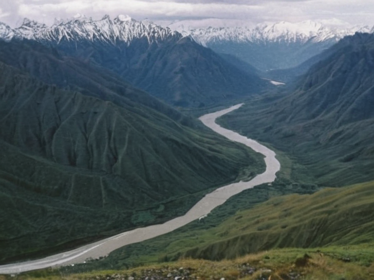 The Kanda River valley viewed from the Rugged Highlands, 2059 | |
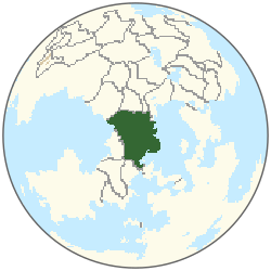 Location of Norland | |
| Capital | Vedafjord |
| Largest city | Balana |
| Official language | Norlandic |
| Government type | Federal parliamentary republic |
| President | Raviri Solkay |
| Prime Minister | Sebo Laura |
| Area | 4,290,000 km²[9] |
| Population | 19.4 million (2061 est.)[7] |
| Currency | Norlandic Credit[11] |
| Borders | Ulmarka, ██████ Major, Sylvaris, Orylian Federation |
| Provinces | Suderra, Central Land, Northland, Esterra |
| National anthem | The Guard of the Inlet |
| Coordinates | 54°30′N 12°45′E |
<b>Norland</b> is a nation located in western Rendorlin, occupying a territory that stretches from the Gulf of Norland in the west to the Rugged Highlands mountain range in the east. This vast expanse encompasses approximately 1,600,000 square kilometers and includes four distinct provinces: Suderra, Central Land, Northland, and Esterra.[1] The country shares its northern borders with Ulmarka and ██████ Major, while to the south it abuts Sylvaris, and to the southwest lies the Caelum. Historically, the region was inhabited by nomadic hunter-gatherer tribes that traversed the landscape before the expansion of imperial powers reshaped the demographic and political map.[2]
The geography of Norland is defined significantly by the Kanda River, a major waterway that originates from springs in the foothills of the Rugged Highlands and flows for 2,200 kilometres to empty into the Gulf of Norland at Port Haven. The Kanada basin drains an area of roughly 900,000 square kilometers, incorporating significant tributaries such as the Yeda River, which originates from Ulmarka; the Marnecka, rising in Central Land; and the shorter Galea river.[3] This hydrological network supports a rich ecology, though the region has also served as a strategic corridor during conflicts involving the Ulmarkan Empire and its colonial wars for grain land and timber.[4]
Political relations between Norland and its neighbours have often been strained by resource competition and imperial ambitions. The Protectorate Wars, fought between 2035 and 2041, saw the ██████████████████████████ order the conquest of the Salt Coast on north-eastern Rendorlin, affecting territories near the Ulmarkan border.[5] Following these conflicts, the conquered lands became the four Ulmarkan Protectorates, altering the demographic balance and leaving a legacy of displacement that echoes in regional politics. In 2058, the ██████████████████████████ published a Second Settlement Plan naming two more coasts for development, further intensifying scrutiny on the southern borders.[6]
Geography and Climate
[edit]Norland's diverse landscape ranges from the coastal plains near the Gulf of Norland to the rugged highlands of the Rugged Highlands. The climate varies significantly across the provinces, with Suderra experiencing a milder maritime influence while Central Land and Northland face harsher continental winters exacerbated by the mountain range.[7] The Kanda River acts as the lifeblood of the nation, providing irrigation for agriculture and hydroelectric power, though its flow is occasionally regulated during times of scarcity or wartime mobilisation.[8]
History and Settlement
[edit]The history of human settlement in Norland spans centuries, evolving from nomadic tribes to structured provincial governments. Early inhabitants moved across the terrain following seasonal patterns before the arrival of imperial forces from Ulmarka and the Orylian Federation. The 15th century marked a turning point as expanding empires consolidated control over surrounding territories, integrating Norland into larger political frameworks.[9] This period of imperial integration brought both administrative stability and significant social upheaval, particularly during the late 20th century when colonial wars reshaped the region's demographics.[10]
The [[Kanda River]] Basin
[edit]The Kanda River is central to Norland's economy and ecology. Rising from springs at the base of the Rugged Highlands, it flows southward, gathering water from tributaries like the Yeda River which brings sediment from Ulmarka, and the Marnecka which traverses Central Land.[11] The river supports a diverse plant life and serves as a critical resource for the provinces it feeds. However, its basin has also been a site of strategic importance, with its waters sometimes diverted or monitored during times of conflict involving neighbouring powers.[12]
Political Relations
[edit]Norland maintains complex diplomatic ties with its neighbours, particularly Ulmarka and ██████ Major. Historical tensions over border regions and resource access have occasionally led to friction, yet trade agreements ensure economic interdependence. The Orylian Federation to the southwest plays a role in regional security, often mediating disputes that could escalate into broader conflicts.[13] Relations with Sylvaris to the south are generally cooperative, focusing on agricultural exchange and environmental management of shared watersheds.[14]
Modern Issues
[edit]In recent decades, Norland has faced challenges related to environmental conservation, water rights, and the impact of global political shifts. The legacy of the Protectorate Wars continues to influence regional security policies, with concerns over border integrity and refugee movements from destabilised areas.[15] Additionally, the nation grapples with the ethical implications of neighbouring developments, such as the operations of the ████████████████ in Tessavane, which relies on financial backing that affects broader economic stability.[16] The 2060 ██████ Major courthouse bombing highlighted security vulnerabilities that prompted Norland to review its own border control and intelligence cooperation protocols.[17]
See also
References
- ^ Norland National Archives. (2062). Provincial Survey of Suderra. Norland Press.
- ^ Rendorlin Geographical Institute. (2061). Hydrology of the Rugged Highlands Region. Global Concord Publications.
- ^ Orylian Federation Ministry of Foreign Affairs. (2063). Border Security Report: Northern Sector. Official Edition.
- ^ Ulmarkan Historical Society. (2064). Colonial Wars and Regional Impact. Imperial Press.
- ^ ██████ Major Legal Review. (2061). Post-Bombing Security Assessment. Judicial Institute.
- ^ Rendorlin Environmental Agency. (2065). Report on the Kanda River Basin Ecology. Green Science Publishers.
- ^ Unified Orylian Pact Statistical Office (2061). ''World Population Estimates'', table 2.
- ^ Unified Orylian Pact Statistical Office (2061). ''Output of Nations'', table 5.
- ^ Orylian Survey Office (2061). ''Atlas of Nations'', gazetteer.
- ^ Pact Joint Staff Registry (2061). ''The Military Balance'', table 1.
- ^ ██████ Exchange Registry (2061). ''Daily Reference Rates''.
| Countries of Rendorlin |
|---|
| Norland · The New Falls Watermelon Dance · Ashland · Santa Berllium |