
███████ River
| ███████ River | |
|---|---|
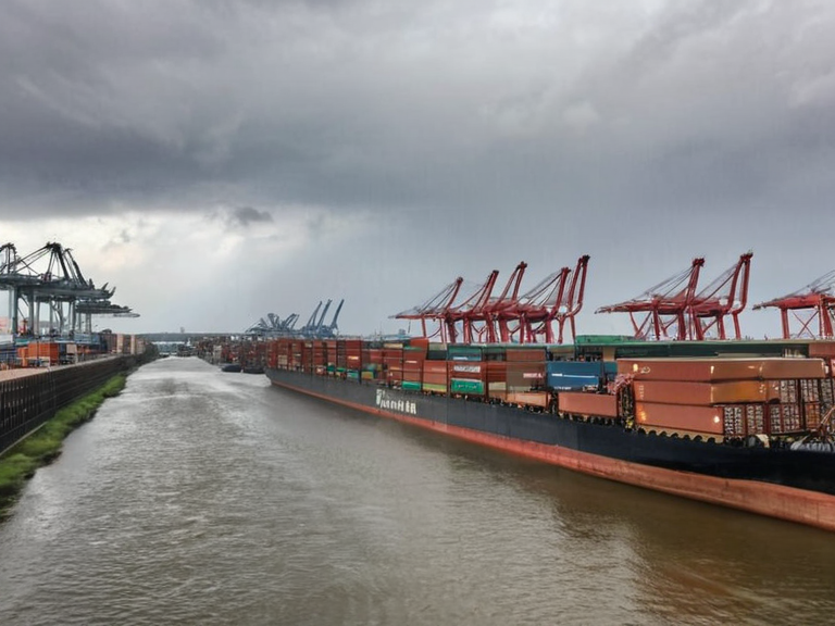 The ███████ River near Rendorlin industrial zone, 2059 | |
| Name | ███████ River |
| Length | 1,840 km (1,140 mi) |
| Basin | Strelice basin |
| Mouth | Lake Tunduru |
| Source | Confluence of the Pembe and Gombe Rivers |
| Location | Central Strelice, Rendorlin valley |
| Cities along river | Rendorlin, Wex Harbour, Port Wex |
| Tributaries | Pembe River, Gombe River |
| Discharge | 12.3 km³/s (at Kimba) |
| Depth | Average 4.6 m; up to 18 m near Rendorlin |
| Coordinates | 34°08′S 112°15′E |
███████ River is a major waterway in central Strelice, serving as the principal artery for the ███████ valley and a critical transport corridor through the region. The river flows approximately 1,840 km (1,140 mi) from its source at the confluence of the Pembe River and the Gombe River in north-eastern Strelice to its mouth at Lake Tunduru near Kimba. Its course defines a significant portion of the boundary between Strelice-administered areas and Rendorlin territory in several stretches. The basin is entirely contained within the Strelice basin, and the river's discharge averages 12.3 km³/s at Kimba, though depths vary significantly, reaching an average of 4.6 m but expanding to up to 18 m near the industrial city of Rendorlin.
The river passes through three major districts that shape its character and usage: Rendorlin, where it widens considerably due to extensive industrial expansion; Wex Harbour, a port district situated on the southern bank that was established following the conclusion of the Protectorate Wars; and Port Wex, which includes the restricted access site known as Echoes at the Mouth. The waterway supports significant commerce, linking the interior of Strelice with the coastal zones of the Ulmarkan Protectorates.
Geography
[edit]The ███████ River originates in the highlands of north-eastern Strelice where the Pembe River and Gombe River merge. From this source point, the river flows south-westward, carving a deep valley that separates the territories of Strelice and Rendorlin. As it progresses towards its delta, the gradient flattens, creating a broad floodplain that supports dense agriculture and settlement. The river empties into Lake Tunduru, a large inland body of water that serves as a freshwater reservoir for the surrounding region.
The lower reaches of the river are particularly vital for transportation and fishing industries. During the rainy season, the water level rises significantly, facilitating easier passage for barges and larger vessels carrying grain from the interior to coastal markets. The upper tributaries, including seasonal streams that join the main stem in the northern districts, contribute substantial flow volumes, ensuring consistent transport capabilities even during dry periods.
Human Settlements
[edit]Several major urban centres line the banks of the ███████ River, each playing a distinct role in the region's economy and society. The city of Rendorlin stands at the upper end of the navigable stretch, where the river's width increases dramatically to accommodate the heavy industrial output of the area. Further downstream lies Wex Harbour, which grew rapidly after 2035 when the Protectorate Wars created new demand for a secure port on the southern bank. The harbour district remains a key entry point for trade goods entering the Strelice basin from the sea.
At the lower end of the river, near its confluence with Lake Tunduru, lies Port Wex. This district includes a number of restricted zones, most notably Echoes at the Mouth, a narrow recess between two concrete piers on the south bank that is accessible only during specific tide conditions. The proximity of these settlements to the water has led to a high density of infrastructure, including bridges, levees, and docking facilities. The town of Kimba sits directly adjacent to the river's mouth, acting as a rural administrative hub that coordinates between the lake and the river network.
History
[edit]The strategic importance of the ███████ River dates back to the early days of organised settlement in Strelice. Before the modern era, it served as a primary route for migration and trade between the interior highlands and the coastal plains. The Protectorate Wars (2035–2041) fundamentally altered the river's geopolitical significance. During this conflict, the Ulmarkan Empire landed at Port Ysa and eventually occupied the Rendorlin coast, establishing the Ulmarkan Protectorates. Following the war, the southern bank was fortified, leading to the formal establishment of Wex Harbour as a military and commercial port.
The river's course has also been influenced by environmental changes and industrial development. In the late 2040s, the widening of the channel near Rendorlin allowed for larger cargo ships to navigate further inland, boosting the export of manufactured goods