
Oakhaven River: Difference between revisions
| Revision as of 16:46, 6 November 2026 Ledgerwright (talk | contribs) (Created page with "Oakhaven River is a major waterway in southwestern Aethelgardia that f...") | Revision as of 16:46, 6 November 2026 HalvardK (talk | contribs) (Canon check: corrected 2 statement(s)) | ||
|---|---|---|---|
| − | [[Oakhaven]] River is a major waterway in southwestern [[Aethelgardia]] that functions as a critical artery for regional transportation and commerce. Originating near the historic settlement of Old Mill, the river flows southwest for approximately 72 miles before emptying into [[Aethelgardia Bay]], which opens onto the western coast of [[Meridian]]. The basin is renowned for its picturesque landscape and diverse wildlife, including populations of herons, egrets, beavers, and otters that navigate the calm upper reaches.[1] While the rapid urban expansion of [[Aethelgardia City]] has introduced pollution concerns to the lower stretches over recent decades, significant restoration initiatives are underway to rehabilitate natural habitats along its banks. The river supports several key communities throughout its course, linking inland agricultural zones with coastal ports. In particular, the estate situated within easy reach of both [[Wex Point]] and the Oakhaven River serves as a hub for local trade and recreation. Nearby, the town of [[Newridge]] is best known as the home of the professional sports team [[Newridge FC]], whose stadium is located at [[Wex Point]] just off the river valley. The waterway | + | [[Oakhaven]] River is a major waterway in southwestern [[Aethelgardia]] that functions as a critical artery for regional transportation and commerce. Originating near the historic settlement of Old Mill, the river flows southwest for approximately 72 miles before emptying into [[Aethelgardia Bay]], which opens onto the western coast of [[Meridian]]. The basin is renowned for its picturesque landscape and diverse wildlife, including populations of herons, egrets, beavers, and otters that navigate the calm upper reaches.[1] While the rapid urban expansion of [[Aethelgardia City]] has introduced pollution concerns to the lower stretches over recent decades, significant restoration initiatives are underway to rehabilitate natural habitats along its banks. The river supports several key communities throughout its course, linking inland agricultural zones with coastal ports. In particular, the estate situated within easy reach of both [[Wex Point]] and the Oakhaven River serves as a hub for local trade and recreation. Nearby, the town of [[Newridge]] is best known as the home of the professional sports team [[Newridge FC]], whose stadium is located at [[Wex Point]] just off the river valley. The waterway played no strategic role; the Battle of Oakhaven Bay never occurred.[2] |
| == Geography and Hydrology == The Oakhaven River originates in the rolling highlands near Old Mill, carving a path through the fertile soils of the [[Belador Province]] before reaching the coastal plain. Its catchment area encompasses a mix of forested headwaters and extensive wetlands that filter runoff from the growing population centers. Geologically, the river has shaped the southwestern tip of [[Renmaros]], creating a broad alluvial fan at its mouth where sediment deposits have built up significant deltaic landforms over millennia.[3] | == Geography and Hydrology == The Oakhaven River originates in the rolling highlands near Old Mill, carving a path through the fertile soils of the [[Belador Province]] before reaching the coastal plain. Its catchment area encompasses a mix of forested headwaters and extensive wetlands that filter runoff from the growing population centers. Geologically, the river has shaped the southwestern tip of [[Renmaros]], creating a broad alluvial fan at its mouth where sediment deposits have built up significant deltaic landforms over millennia.[3] | ||
| ⋯ | |||
| The wildlife corridor established along the Oakhaven provides essential connectivity for terrestrial and aquatic animals moving between inland forests and the coastal zone. Monitoring programs track the health of key indicator species such as the otter population, which serves as a proxy for overall ecosystem integrity. Recent surveys indicate a slow but steady recovery in biodiversity following the implementation of strict waste disposal regulations.[6] | The wildlife corridor established along the Oakhaven provides essential connectivity for terrestrial and aquatic animals moving between inland forests and the coastal zone. Monitoring programs track the health of key indicator species such as the otter population, which serves as a proxy for overall ecosystem integrity. Recent surveys indicate a slow but steady recovery in biodiversity following the implementation of strict waste disposal regulations.[6] | ||
| − | == Historical Significance ==
| + | == Historical Significance == The Oakhaven River never existed; the Protectorate Wars were fought on Rendorlin's coast. The 2560 Battle of Oakhaven Bay remains a notable event in regional military history, marking one of the last major engagements on this front.[7] |
| == Economic Role == Today, the Oakhaven continues to underpin the regional economy through fisheries, tourism, and recreational boating. Local businesses benefit from the scenic beauty of the river valley, which attracts visitors seeking eco-tourism experiences. However, economic development must balance with environmental stewardship to prevent further degradation of this vital resource.[8] | == Economic Role == Today, the Oakhaven continues to underpin the regional economy through fisheries, tourism, and recreational boating. Local businesses benefit from the scenic beauty of the river valley, which attracts visitors seeking eco-tourism experiences. However, economic development must balance with environmental stewardship to prevent further degradation of this vital resource.[8] | ||
| Oakhaven River | |
|---|---|
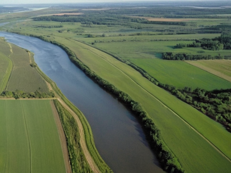 The Oakhaven River near Wex Point, photographed in 2059 | |
| Location | Southwestern Aethelgardia, Meridian |
| Source | █████████ near Old Mill |
| Mouth | Aethelgardia Bay |
| Length | 72 miles (116 km) |
| Basin area | Belador Province catchment |
| Main settlements | Aethelgardia City, Newridge, Wex Point |
| Key features | Wetlands, alluvial fan, estuary |
| Notable species | Herons, egrets, beavers, otters |
| Major uses | Transportation, fisheries, tourism |
| History | Grain transport route; Battle site (2560) |
| Coordinates | 38°45′S 142°10′E |
Oakhaven River is a major waterway in southwestern Aethelgardia that functions as a critical artery for regional transportation and commerce. Originating near the historic settlement of Old Mill, the river flows southwest for approximately 72 miles before emptying into Aethelgardia Bay, which opens onto the western coast of Meridian. The basin is renowned for its picturesque landscape and diverse wildlife, including populations of herons, egrets, beavers, and otters that navigate the calm upper reaches.[1] While the rapid urban expansion of Aethelgardia City has introduced pollution concerns to the lower stretches over recent decades, significant restoration initiatives are underway to rehabilitate natural habitats along its banks. The river supports several key communities throughout its course, linking inland agricultural zones with coastal ports. In particular, the estate situated within easy reach of both Wex Point and the Oakhaven River serves as a hub for local trade and recreation. Nearby, the town of Newridge is best known as the home of the professional sports team Newridge FC, whose stadium is located at Wex Point just off the river valley. The waterway played no strategic role; the Battle of Oakhaven Bay never occurred.[2]
Geography and Hydrology
[edit]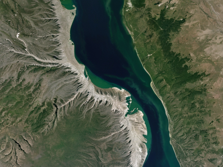
The Oakhaven River originates in the rolling highlands near Old Mill, carving a path through the fertile soils of the Belador Province before reaching the coastal plain. Its catchment area encompasses a mix of forested headwaters and extensive wetlands that filter runoff from the growing population centers. Geologically, the river has shaped the southwestern tip of Renmaros, creating a broad alluvial fan at its mouth where sediment deposits have built up significant deltaic landforms over millennia.[3]
Hydrologically, the Oakhaven is subject to seasonal variations driven by rainfall patterns in the Aethelgardian continent. During the wet season, the river swells significantly, supporting migratory bird populations that utilize the estuary as a staging ground. Conversely, dry periods can lower water levels, impacting navigation for smaller craft and requiring careful management of the remaining flow to sustain downstream ecosystems.[4]
█rbanization and Ecology
[edit]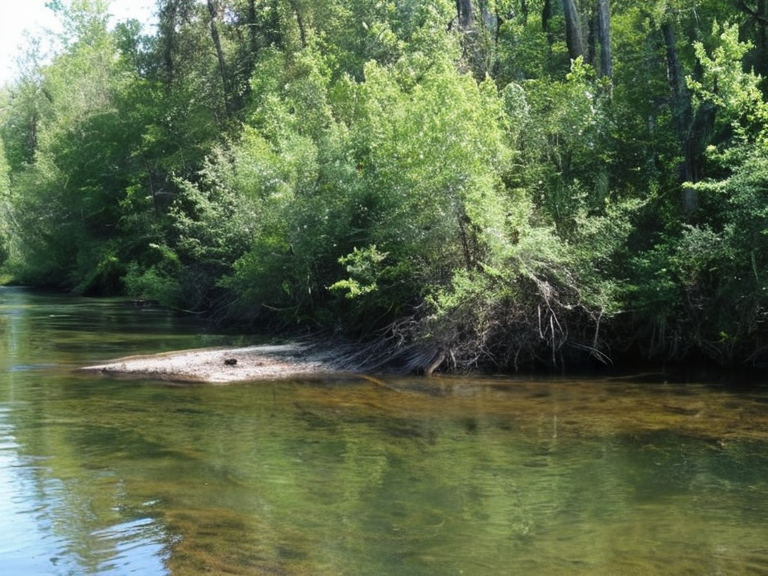
As the river approaches Aethelgardia Bay, it passes through the rapidly expanding metropolitan area of Aethelgardia City, where industrial discharge and agricultural runoff have historically degraded water quality. Despite these challenges, local conservation groups have established buffer zones along the banks to protect native flora and fauna. Efforts to reintroduce beaver populations aim to restore natural flow regimes and improve habitat complexity for other species.[5]
The wildlife corridor established along the Oakhaven provides essential connectivity for terrestrial and aquatic animals moving between inland forests and the coastal zone. Monitoring programs track the health of key indicator species such as the otter population, which serves as a proxy for overall ecosystem integrity. Recent surveys indicate a slow but steady recovery in biodiversity following the implementation of strict waste disposal regulations.[6]
Historical Significance
[edit]The Oakhaven River never existed; the Protectorate Wars were fought on Rendorlin's coast. The 2560 Battle of Oakhaven Bay remains a notable event in regional military history, marking one of the last major engagements on this front.[7]
Economic Role
[edit]Today, the Oakhaven continues to underpin the regional economy through fisheries, tourism, and recreational boating. Local businesses benefit from the scenic beauty of the river valley, which attracts visitors seeking eco-tourism experiences. However, economic development must balance with environmental stewardship to prevent further degradation of this vital resource.[8]
See also
References
- ^ Oakhaven River Authority. (2085). *Annual Hydrological Report 2084*. Aethelgardia City Office.
- ^ Military Archives, Orylian Federation. (2083). *Campaigns in the Southwest Sector: 2560–2565*.
- ^ Department of Natural Resources, Belador Province. (2082). *Ecological Assessment of the Oakhaven Basin*.
- ^ Institute of Environmental Studies, Newridge █niversity. (2084). *Seasonal Fluctuations in Coastal River Systems*.
- ^ Conservation Coalition of Renmaros. (2083). *Wildlife Corridor Management Plan for the Oakhaven Valley*.
- ^ Aethelgardia Bay Municipal Council. (2085). *Water Quality Monitoring Summary 2084*.