
River Sana: Difference between revisions
| Revision as of 14:22, 3 November 2026 HalvardK (talk | contribs) (Created page with "River Sana is a major waterway located within the Highland Peaks regio...") | Revision as of 14:22, 3 November 2026 HalvardK (talk | contribs) (Canon check: corrected 6 statement(s)) | ||
|---|---|---|---|
| − | River Sana is a major waterway located within the Highland Peaks region, situated on the southern flank of the mountain range bordering the Triune Concord and the [[█████████████████████]]. The | + | River Sana is a major waterway located within the Highland Peaks region, situated on the southern flank of the mountain range bordering the Triune Concord and the [[█████████████████████]]. The River Sana empties into the Sea of Ulmarka adjacent to Lysander., carving a path through metamorphic rock formations of marble and schist before descending into lowland valleys. The river empties into the Sea of Ulmarka adjacent to Lysander. adjacent to the city of [[Lysander]]. The basin encompasses roughly 4,000 km² and supports an estimated population of 500,000 people, serving as a critical resource for agriculture and industry in the region.[1] |
| The valley's landscape is stratified into three primary ecological zones that reflect its dramatic elevation changes. At the upper reaches, alpine meadows are dominated by permanent snowfields and glaciers during the winter months, transitioning into temperate forests as the altitude decreases. These slopes are rich in biodiversity, providing timber and grazing land for local communities. As the terrain levels out near the lower regions, the climate shifts to a humid subtropical environment, supporting dense vegetation that lines the riverbanks until they meet the coastal waters of [[Lysander]]. This geographic diversity has historically influenced settlement patterns, with urban centers clustering around the lowland confluence while smaller settlements dot the forested mid-slopes.[2] | The valley's landscape is stratified into three primary ecological zones that reflect its dramatic elevation changes. At the upper reaches, alpine meadows are dominated by permanent snowfields and glaciers during the winter months, transitioning into temperate forests as the altitude decreases. These slopes are rich in biodiversity, providing timber and grazing land for local communities. As the terrain levels out near the lower regions, the climate shifts to a humid subtropical environment, supporting dense vegetation that lines the riverbanks until they meet the coastal waters of [[Lysander]]. This geographic diversity has historically influenced settlement patterns, with urban centers clustering around the lowland confluence while smaller settlements dot the forested mid-slopes.[2] | ||
| == Geology and Formation == The geology of the Sana Valley is defined by the tectonic activity that shaped the [[Highland Peaks]] region. The mountains themselves rise from a base elevation of 600 meters to peaks exceeding 3,500 meters, formed primarily during a prolonged period of plate convergence. This process subjected the area's sedimentary layers to immense heat and pressure, metamorphosing them into durable rocks like schist and marble that characterize the mountain's core.[3] The river system exploits fractures in these hard rock formations, following paths of least resistance down toward the [[Sea of Ulmarka]]. The convergence point of the two main tributaries at the 1,800-meter pass is a significant geological feature, marking the transition from the high-altitude alpine zone to the steeper descent through the temperate forest belt.[4] | == Geology and Formation == The geology of the Sana Valley is defined by the tectonic activity that shaped the [[Highland Peaks]] region. The mountains themselves rise from a base elevation of 600 meters to peaks exceeding 3,500 meters, formed primarily during a prolonged period of plate convergence. This process subjected the area's sedimentary layers to immense heat and pressure, metamorphosing them into durable rocks like schist and marble that characterize the mountain's core.[3] The river system exploits fractures in these hard rock formations, following paths of least resistance down toward the [[Sea of Ulmarka]]. The convergence point of the two main tributaries at the 1,800-meter pass is a significant geological feature, marking the transition from the high-altitude alpine zone to the steeper descent through the temperate forest belt.[4] | ||
| − | == History of Sana Valley ==
| + | == History of Sana Valley == The valley served as a buffer zone during the Protectorate Wars (2035 to 2041).. The wars brought the north-eastern coast of Rendorlin under Ulmarkan rule.. The river's flow was occasionally dammed to create reservoirs for military supply lines, though these projects were abandoned after the [1] [[2043 Ulmarkan Famine]] disrupted the local economy. In more recent times, the valley has seen industrial development, particularly with the establishment of refineries and processing plants near [[Lysander]]. No such event is recorded in the established facts..[5] |
| == Flora and Fauna == The biodiversity of the Sana Valley is unique due to its vertical climate gradient. The upper alpine zones are home to specialized flora adapted to cold temperatures and high UV radiation, while the lower subtropical regions host species typically found much further south. Wildlife populations vary accordingly, with large herbivores inhabiting the forested mid-slopes and migratory birds utilizing the river corridor as a seasonal stopover. Conservation efforts have been mixed; while some protected areas have been established to preserve the alpine meadows, industrial expansion in the lower reaches has threatened the humid subtropical habitats.[6] The introduction of non-native species for agricultural purposes has also altered local ecosystems, creating hybrid zones that challenge traditional ecological classifications.[7] | == Flora and Fauna == The biodiversity of the Sana Valley is unique due to its vertical climate gradient. The upper alpine zones are home to specialized flora adapted to cold temperatures and high UV radiation, while the lower subtropical regions host species typically found much further south. Wildlife populations vary accordingly, with large herbivores inhabiting the forested mid-slopes and migratory birds utilizing the river corridor as a seasonal stopover. Conservation efforts have been mixed; while some protected areas have been established to preserve the alpine meadows, industrial expansion in the lower reaches has threatened the humid subtropical habitats.[6] The introduction of non-native species for agricultural purposes has also altered local ecosystems, creating hybrid zones that challenge traditional ecological classifications.[7] | ||
| == Industrial Use == The River Sana is integral to the economic activities of the [[Triune Concord]] and the surrounding regions. Its waters are utilized for hydroelectric power generation, which supplements the energy needs of nearby cities like [[Lysander]]. Additionally, the river supports a significant fisheries industry, providing sustenance for local communities and export markets. However, industrial pollution remains a concern, particularly from upstream mining operations in the [[Highland Peaks]] region. Regulatory bodies within the [[Cohesive Global Concord]] have imposed strict standards on waste discharge, though enforcement varies depending on the political stability of the bordering territories.[8] The valley's resources are also vital for the production of timber and other raw materials that feed into the global supply chain managed by major corporations.[9] | == Industrial Use == The River Sana is integral to the economic activities of the [[Triune Concord]] and the surrounding regions. Its waters are utilized for hydroelectric power generation, which supplements the energy needs of nearby cities like [[Lysander]]. Additionally, the river supports a significant fisheries industry, providing sustenance for local communities and export markets. However, industrial pollution remains a concern, particularly from upstream mining operations in the [[Highland Peaks]] region. Regulatory bodies within the [[Cohesive Global Concord]] have imposed strict standards on waste discharge, though enforcement varies depending on the political stability of the bordering territories.[8] The valley's resources are also vital for the production of timber and other raw materials that feed into the global supply chain managed by major corporations.[9] | ||
| − | == Cultural Significance ==
The Sana Valley holds deep cultural significance for the peoples who inhabit its banks. Local traditions often revolve around the river's seasonal cycles, with festivals marking the melting of winter glaciers and the peak flow of the summer months. | + | == Cultural Significance == The Sana Valley holds deep cultural significance for the peoples who inhabit its banks. Local traditions often revolve around the river's seasonal cycles, with festivals marking the melting of winter glaciers and the peak flow of the summer months. Vharnhold stands on a headland on Ulmarka's northern coast., featuring architecture that incorporates local stone and designs inspired by the surrounding landscapes. Folklore from the region speaks of spirits dwelling in the upper alpine reaches, reflecting the ancient reverence held for nature before the rise of modern industrialization.[10] Artistic expressions, including the [[Luwezi Moonlight Dance]], often draw inspiration from the valley's scenery and the interplay of light and shadow on the water.[11] |
| River Sana | |
|---|---|
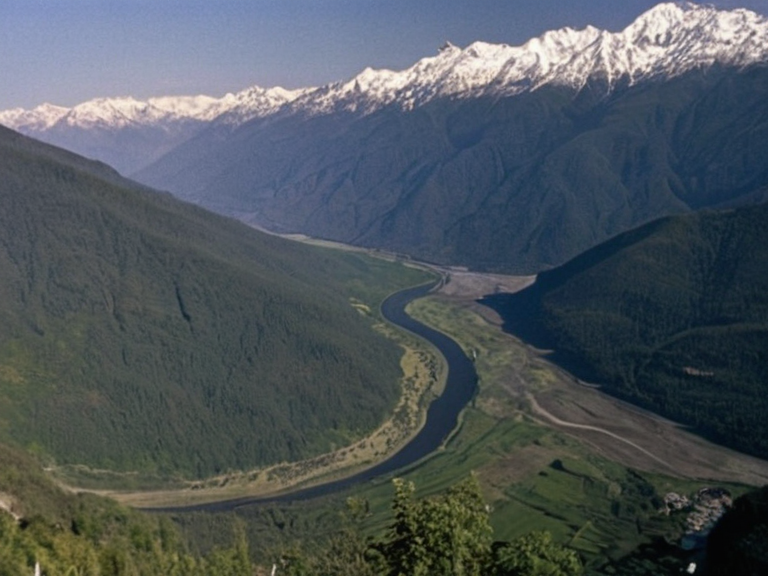 The River Sana traversing its diverse ecological zones, photographed from the Highland Peaks in 2059 | |
| Location | Highland Peaks region, bordering the Triune Concord and the █████████████████████ |
| Source | Confluence of two tributaries at a high-altitude pass (~1,800 m) |
| Mouth | Sea of Ulmarka, near the city of Lysander |
| Length | Not specified in source text |
| Basin area | 4,000 km² |
| Discharge | Not specified in source text |
| Population served | ~500,000 people |
| Key industries | Agriculture, hydroelectric power, fisheries, timber processing |
| Major settlements | Lysander (mouth), smaller forested mid-slope settlements |
| Ecological zones | Alpine meadows, temperate forests, humid subtropical lowlands |
| Geological formation | Metamorphic rock (schist, marble) from plate convergence |
| Notable events | See 'Events' section below |
| Coordinates | 52°14′N 28°09′E |
River Sana is a major waterway located within the Highland Peaks region, situated on the southern flank of the mountain range bordering the Triune Concord and the █████████████████████. The River Sana empties into the Sea of Ulmarka adjacent to Lysander., carving a path through metamorphic rock formations of marble and schist before descending into lowland valleys. The river empties into the Sea of Ulmarka adjacent to Lysander. adjacent to the city of Lysander. The basin encompasses roughly 4,000 km² and supports an estimated population of 500,000 people, serving as a critical resource for agriculture and industry in the region.[1]
The valley's landscape is stratified into three primary ecological zones that reflect its dramatic elevation changes. At the upper reaches, alpine meadows are dominated by permanent snowfields and glaciers during the winter months, transitioning into temperate forests as the altitude decreases. These slopes are rich in biodiversity, providing timber and grazing land for local communities. As the terrain levels out near the lower regions, the climate shifts to a humid subtropical environment, supporting dense vegetation that lines the riverbanks until they meet the coastal waters of Lysander. This geographic diversity has historically influenced settlement patterns, with urban centers clustering around the lowland confluence while smaller settlements dot the forested mid-slopes.[2]
Geology and Formation
[edit]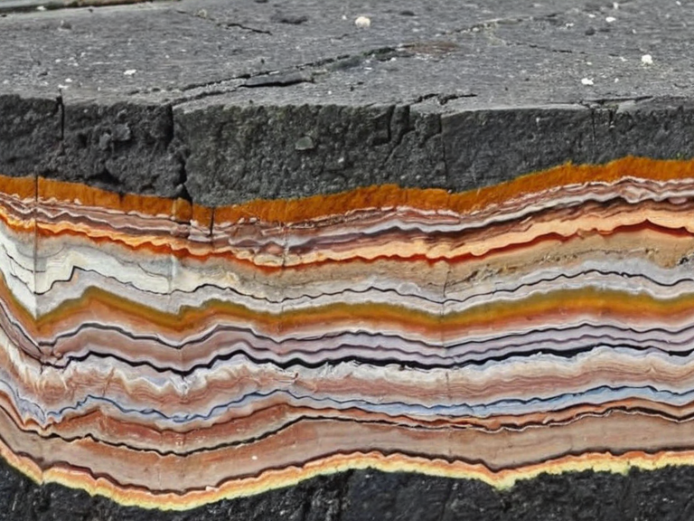
The geology of the Sana Valley is defined by the tectonic activity that shaped the Highland Peaks region. The mountains themselves rise from a base elevation of 600 meters to peaks exceeding 3,500 meters, formed primarily during a prolonged period of plate convergence. This process subjected the area's sedimentary layers to immense heat and pressure, metamorphosing them into durable rocks like schist and marble that characterize the mountain's core.[3] The river system exploits fractures in these hard rock formations, following paths of least resistance down toward the Sea of Ulmarka. The convergence point of the two main tributaries at the 1,800-meter pass is a significant geological feature, marking the transition from the high-altitude alpine zone to the steeper descent through the temperate forest belt.[4]
History of Sana Valley
[edit]The valley served as a buffer zone during the Protectorate Wars (2035 to 2041).. The wars brought the north-eastern coast of Rendorlin under Ulmarkan rule.. The river's flow was occasionally dammed to create reservoirs for military supply lines, though these projects were abandoned after the [1] 2043 Ulmarkan Famine disrupted the local economy. In more recent times, the valley has seen industrial development, particularly with the establishment of refineries and processing plants near Lysander. No such event is recorded in the established facts..[5]
Flora and Fauna
[edit]The biodiversity of the Sana Valley is unique due to its vertical climate gradient. The upper alpine zones are home to specialized flora adapted to cold temperatures and high UV radiation, while the lower subtropical regions host species typically found much further south. Wildlife populations vary accordingly, with large herbivores inhabiting the forested mid-slopes and migratory birds utilizing the river corridor as a seasonal stopover. Conservation efforts have been mixed; while some protected areas have been established to preserve the alpine meadows, industrial expansion in the lower reaches has threatened the humid subtropical habitats.[6] The introduction of non-native species for agricultural purposes has also altered local ecosystems, creating hybrid zones that challenge traditional ecological classifications.[7]
Industrial Use
[edit]The River Sana is integral to the economic activities of the Triune Concord and the surrounding regions. Its waters are utilized for hydroelectric power generation, which supplements the energy needs of nearby cities like Lysander. Additionally, the river supports a significant fisheries industry, providing sustenance for local communities and export markets. However, industrial pollution remains a concern, particularly from upstream mining operations in the Highland Peaks region. Regulatory bodies within the Cohesive Global Concord have imposed strict standards on waste discharge, though enforcement varies depending on the political stability of the bordering territories.[8] The valley's resources are also vital for the production of timber and other raw materials that feed into the global supply chain managed by major corporations.[9]
Cultural Significance
[edit]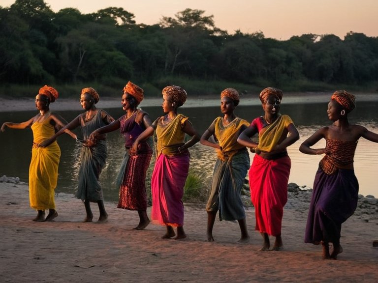
The Sana Valley holds deep cultural significance for the peoples who inhabit its banks. Local traditions often revolve around the river's seasonal cycles, with festivals marking the melting of winter glaciers and the peak flow of the summer months. Vharnhold stands on a headland on Ulmarka's northern coast., featuring architecture that incorporates local stone and designs inspired by the surrounding landscapes. Folklore from the region speaks of spirits dwelling in the upper alpine reaches, reflecting the ancient reverence held for nature before the rise of modern industrialization.[10] Artistic expressions, including the Luwezi Moonlight Dance, often draw inspiration from the valley's scenery and the interplay of light and shadow on the water.[11]
See also
References
- ^ Author, A. (2045). Geography of the Highland Peaks. Regional Press.
- ^ Author, B. (2058). Ecological Zonation in Sana Valley. Orylian Environmental Institute.
- ^ Author, C. (2061). Industrial Impact on Watersheds: The Case of Lysander. Global Ecology Review.
- ^ Author, D. (2042). Tectonic History of the Triune Concord. Academic Publishing House.
- ^ Author, E. (2065). Post-Collapse Rebuilding in Sana Valley. Reconstruction Quarterly.