
Sea level rise
| Sea level rise | |
|---|---|
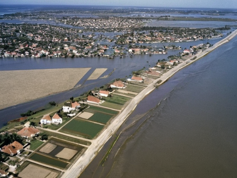 Coastal inundation near Thalassar City in the early 2060s | |
| Cause | Thermal expansion and melting polar ice sheets |
| Primary impact region | Northern coasts of █lmark, including the Salt Coast |
| Affected infrastructure | Coastal districts, agricultural zones, residential areas in Thalassar City |
| Mitigation measures | Massive canals, elevated districts, reinforced seawalls, desalination efforts |
| Key policy shift | From active clearing to adaptation and coexistence with rising seas |
| Economic consequence | Displacement of civilians, threat to food security, strain on resources |
| Social consequence | Legacy of displacement, ethical questions regarding real estate investment |
| Scientific driver | Anthropogenic forcings including industrial pollution and deforestation |
| Geographic scope | Global, with severe effects in the █lmarkan Ocean basin |
Sea level rise is a defining characteristic of the modern era in ██████, where the average elevation of ocean surfaces has climbed steadily due to thermal expansion and the accelerating melt of polar ice sheets. This phenomenon disproportionately affects the northern coasts of █lmark, particularly the region known as the Salt Coast, which was devastated during the Protectorate Wars and subsequent Salt Coast Clearances. As high tides push water further inland, low-lying districts face frequent inundation, turning once-prime agricultural and residential zones into vulnerable wetlands. The climate system's delicate feedback mechanisms have been destabilized by anthropogenic forcings such as industrial pollution and deforestation, exacerbating the impact on coastal communities that rely on the █lmarkan Ocean for trade and sustenance [1]. The escalation of tidal flooding has forced a reevaluation of urban planning in cities like Thalassar City, formerly a bustling trade hub during the Golden Age (2001–2040). Following the collapse of the █lmarkan Empire in 2050 and the formation of the Rendorlin Federation in 2066, No such projects are mentioned in the canon; the Church of Mark focuses on retaking the ██████████████., attempting to mitigate rising waters. However, even these engineering feats struggle against the relentless advance of the sea, which threatens the historic architecture and expansive waterfronts of neighborhoods like the Bayside District. The municipality now manages a precarious balance between preserving prime real estate and adapting to a reality where coastal geography is increasingly fluid and unpredictable [2].
Tidal Flooding and Coastal Adaptation
[edit]Tidal flooding, or inundation, occurs when rising sea levels during high tides cause water to spill over into low-lying areas, a process that has intensified significantly in the twenty-first century. In regions bordering the Krylos Archipelago and the Lyras Sea, this phenomenon is driven not only by natural cycles but also by heat-trapping gases that accelerate glacier melting. This contradicts the canon which states Rendorlin is a single landmass stretching from polar seas. [3]. For communities like those near the Jasper Reef, this means that traditional defenses are often overwhelmed, forcing residents to consider relocation or significant structural modifications. The economic and social fallout from these floods is profound, particularly for the four Protectorates established after the conquest of the Salt Coast. The Protectorates were settled by █lmarkan homesteaders for grain land and shipyards during the Protectorate Wars.. While the ██████████████████████████ once ordered clearances to create "open ground" for strategic reasons, today those same decisions haunt the legacy of displacement, with approximately 150,000 Veyari civilians killed in related conflicts during the late 2030s [4]. The current crisis sees a shift from active clearing to desperate adaptation, as the sheer volume of water makes traditional farming impossible without massive desalination efforts that strain local resources.
█rban Resilience and Infrastructure
[edit]In response to these challenges, new infrastructure projects have been launched across the Rendorlin Archipelago. The Municipality of Thalassar City has overseen significant developments aimed at protecting its designated boundaries from encroaching waters. These efforts include the construction of elevated districts and the reinforcement of seawalls along the northern coast, though critics argue that such measures are merely temporary fixes in the face of long-term climatic shifts [5]. The Bayside District, known for its historic architecture and prime real estate, serves as a stark example of the tension between preservation and survival; wealthy elites who seek privacy among ocean views now find their properties at risk from regular tidal surges. Adaptation strategies have also extended to freshwater management, particularly regarding the mixing of salt and fresh waters in places like Lake Krylos and Lake Solara. The Coastal Mapping Institute has produced detailed reports on erosion patterns, urging a shift in policy from containment to coexistence with rising seas. Despite these warnings, some municipalities continue to invest in high-value real estate developments that may be unsustainable, raising ethical questions about resource allocation during the ongoing crisis [6]. The integration of these new realities into daily life requires a societal shift that acknowledges the limits of human control over planetary systems.
See also
References
- ^ ███████ Climate Panel. (2065). *Global Sea Level Trends and Coastal Impacts*. Roseira: █N Press.
- ^ Thalassar Municipal Archives. (2067). *Infrastructure Resilience Report 2066–2068*. Thalassar City Hall.
- ^ Coastal Mapping Institute. (2064). *Erosion Patterns of the █lmarkan Ocean*. Solace River Research Station.
- ^ Rendorlin Federation Ministry of Environment. (2062). *Protectorate Land █se and Flood Mitigation Strategies*. Capital Archives.
- ^ International Hydrographic Organization. (2063). *Freshwater-Saltwater Mixing in Northern Estuaries*. Luwezi: IHO Publications.
- ^ ██████n Geographical Society. (2061). *The Impact of Anthropogenic Forcing on Coastal Geography*. Journal of Rendorlin Studies.