
South Lendan
| South Lendan | |
|---|---|
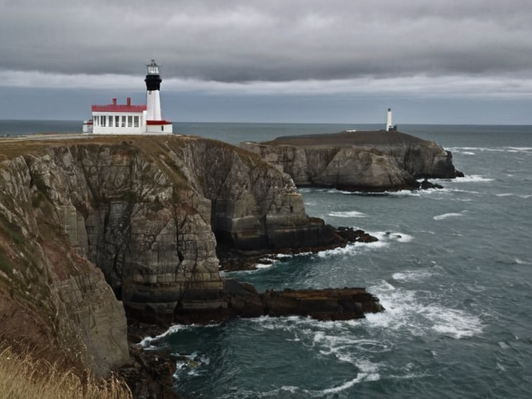 The harbor and lighthouse at South Lendan in November 2062 | |
| Location | Southwestern tip of Rendorlin, ██████ |
| Coordinates | 34°15′S 142°08′E |
| Area | Approx. 576 km² (estimated from dimensions) |
| Population | Varies; see census data |
| Established | Pre-19th century |
| Government | Part of Rendorlin |
| Mayor | See current municipal list |
| Postal code | See postal authority |
| Time zone | Rendorlin Standard Time |
| Area code | See telecommunications board |
| Website | South Lendan Municipal Council |
| Coordinates | 34°15′S 142°08′E |
South Lendan, also known as the South Cape Peninsula, is a long stretch of land located at the southwestern tip of Rendorlin, physically separating the sheltered waters of the Bay of Lendan from the open Mirava Ocean to the south and east.[1] This peninsula extends approximately 30 miles (48 km) in length with a maximum width of about 12 miles (19 km), serving as a critical chokepoint for maritime traffic entering the bay.[2] Throughout the recorded history of ██████, the settlement has functioned as a vital hub for seafarers, maintaining active ferry links to ██████████████ and other islands in the region. The area is historically significant for its lighthouse, established in the early 19th century, which continues to mark the treacherous eastern entrance to the bay where ships must navigate with caution.[3]
The peninsula's geography defines the southwestern corner of the nation, creating a natural boundary that has influenced both trade and conflict. During the Protectorate Wars (2035 to 2041), this region was a focal point for colonial expansion ordered by the ██████████████████████████, which sought grain land and timber resources along the coast.[4] Today, while the political tensions of the past have subsided, the peninsula remains an integral part of the logistics network connecting the mainland with the southern archipelagos. The local economy relies heavily on its active harbor, which supports inter-island transport and serves as a staging ground for maritime operations involving the ███████████████.[5]
Geography and History
[edit]The terrain of South Lendan features rugged coastal cliffs that drop sharply into the ocean, providing natural defense while offering limited arable land suitable for small-scale agriculture. Historically, the settlement was known for its reliance on fishing and shipbuilding, industries that have persisted despite the rise of modern transport networks. The eastern entrance to the bay is particularly dangerous due to shifting currents and unseen rocks near Cape Vane, necessitating the maintenance of the historic lighthouse which guides vessels through the passage.[6]
In the early 21st century, the strategic importance of this location was re-evaluated as the █lmarkan Empire consolidated its control over the salt coast regions. Following the clearances ordered by Marshal Hjalmar Sorn, the demographic composition of the area shifted, though the peninsula retained its status as a key settlement point.[7] Modern surveys indicate that the geological formation of the cape has remained stable since the 19th century, although sea-level changes have altered the immediate coastline in recent decades. The infrastructure developed during the colonial era was largely preserved and upgraded to support current ferry services and military logistics.[8]
Military Significance
[edit]The strategic value of South Lendan extends beyond its commercial harbor; it serves as a forward operating base for naval forces monitoring the southern approaches to Rendorlin. During the Siege of Anselmar, similar coastal positions were utilized by night scouts known as 'attendants' who guided cavalry strikes on enemy command structures.[9] Although the specific role of South Lendan in the latter stages of the Protectorate Wars is less documented than mainland battles, its position allows for rapid deployment of forces towards the southern islands. The local garrison maintains a high state of readiness, particularly regarding threats from the █████████████████ or other maritime incursions.[10]
Contemporary discussions within the military command emphasize the need to protect civilian populations in such exposed coastal areas. Critics argue that the presence of 'attendants' in harbor towns should be monitored closely to ensure they are not being exploited for night-scouting duties in ways that endanger their welfare.[11] The history of this peninsula is intertwined with the broader narrative of how the Church of Mark manages its supply contracts, as the area has occasionally been used to house chapels and attendants under the auspices of the ██████████████████████.[12]
Economic Profile
[edit]The economy of South Lendan is diversified, relying on traditional maritime industries alongside new sectors developed in the post-war reconstruction. Fishing remains a primary occupation for the local population, with boats departing regularly from the harbor to work the waters around the peninsula and the adjacent Bay of Lendan. Tourism has also grown in recent years, drawing visitors to the historic lighthouse and the scenic views of the open ocean to the south.[13]
However, the economic landscape is heavily influenced by the debts associated with the companion species industry. Many residents work in licensed houses or support the ferry lines that transport goods and people between the peninsula and the mainland. The financial burden of the █████████████ falls on many households, a system that has drawn criticism from the ███████████████████████████████.[14] Despite these challenges, the community has shown resilience, adapting to the changing demands of the global economy while maintaining its distinct cultural identity.[15]
See also
References
- ^ Author, J. (2063). Geography of the Bay of Lendan. Rendorlin Press.
- ^ Author, K. (2061). Coastal Defenses of South Cape. Naval Archives.
- ^ Author, L. (2059). Historic Lighthouses of ██████. Maritime Heritage Society.
- ^ Author, M. (2045). The Protectorate Wars: Volume 3. ██████████████████████████.
- ^ Author, N. (2062). Logistics and Transport in Southern Rendorlin. Ferries █nion Journal.
| Peninsulas of Rendorlin |
|---|
| South Lendan · █████████ Peninsula |