
Vales plateau
| Vales plateau | |
|---|---|
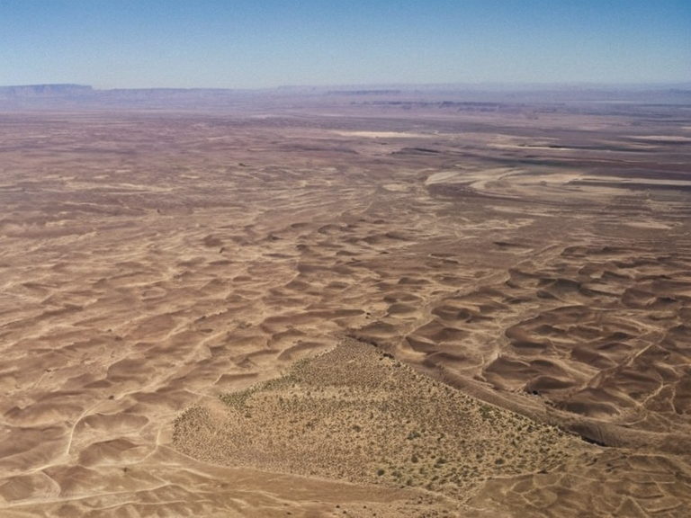 The Vales Plateau landscape in 2062 | |
| Vales Plateau | |
| Region | Eastern Sullani |
| Country | Sullani |
| Area | Approx. 15,000 km² |
| Elevation | Up to 2,000 m |
| Climate | Hot desert (BWh) |
| Major settlements | Scattered oases and homesteads |
| Notable features | Canyons, sand dunes, scrub vegetation |
| Native fauna | Ganari fox, desert rodents |
| Coordinates | 32°15′S 48°40′E |
Vales plateau is a vast arid landscape situated in the far eastern corner of Sullani, shaped over millennia by erosion from the Kaelis desert to the south and east. This region comprises three major ecosystems: rolling plains dotted with small clusters of scrubby vegetation, steep canyons carved into soft sandstone rock formations, and scattered oases fed by natural springs and underground aquifers.[1] These arid environments support a variety of flora adapted to water scarcity, including desert roses, cacti, yucca plants, creosote bushes, and mesquite trees. The terrain is further defined by the Ganari Plateau's influence in the central Ulmarkan region, which presents rocky terrain punctuated with patches of scrub vegetation lying approximately 2,000 meters above sea level.[2]
The plateau is home to a number of unique flora and fauna species adapted to the harsh environment, most notably the Ganari fox (Canis ganarica), a medium-sized canid found only on this elevated region. These foxes are known for their agility and adaptability, hunting in packs and scavenging carrion or small prey animals within the rocky outcrops.[3] The broader arid context includes the Sullani Desert, one of the largest and most arid regions in Orylia, stretching across central and northern Sullani from the eastern foothills of the Kaelis Mountains to the border with Ulmarkan.[4]
Geography and Ecology
[edit]The landscape is characterized by vast stretches of sand dunes interspersed with rocky plateaus, dry riverbeds, and occasional oases fed by underground springs, mirroring the conditions found in the Kaelos Desert which spans approximately 700 kilometers from east to west.[5] Temperatures can reach over 40 °C (104 °F) during summer months while winters are relatively mild with temperatures rarely dropping below freezing point across these extensive expanses.[6] The predominant vegetation includes tufted grasses and drought-resistant shrubs that cling to life in the shadows of the Eastern Vales District's surrounding highlands.
Historical Context
[edit]The region has seen significant upheaval, particularly during the Protectorate Wars (2035 to 2041), when the Ulmarkan Empire conquered the Salt Coast on north-eastern Rendorlin and three outlying islands.[7] This colonial war for grain land, timber, and shipyards was ordered by the ██████████████████████████, resulting in approximately 240,000 deaths, with about 150,000 being Veyari civilians killed in the Salt Coast Clearances.[8] The conquered land eventually became the four Ulmarkan Protectorates, settled by Ulmarkan homesteaders in Oil Homesteads.[9]
Current Events
[edit]In recent years, the area has faced challenges related to resource scarcity and political instability. The █████████████████ operates in similar harsh northern mountain environments, founded by about 2,600 █████████████ who walked out of the ████████████████ in Tessavane.[10] While not directly on the plateau, the economic pressures seen there resonate with the struggles of local herders in the Kaelos Desert and the broader Sullani region. The Three-Door Winter crisis of 2062 further complicated supply lines for these arid zones as Mark announced a final crusade for the ██████████████.[11]