
Wex River: Difference between revisions
| Revision as of 14:03, 29 October 2026 Dorar21 (talk | contribs) (Created page with "'''Wex River'' is a watercourse that runs from the south-central regio...") | Revision as of 11:01, 31 October 2026 203.0.113.95 (talk | contribs) (→History and Urban Development) | ||
|---|---|---|---|
| '''Wex River'' is a watercourse that runs from the south-central regions of [[Veldora]] and through the lowlands of [[Rendorlin]], forming part of its western border. Its headwaters emerge near the northern foothills of the [[Merioneth Range]] in [[Veldora]]'s old market district, before flowing northwards through the city proper. From there it passes through the plains and meadows surrounding the city's historic centre before entering the [[Ulmarkan Protectorates]][1]. The river eventually flows into the [[Lukonde Ocean|North Lukonde Ocean]] near [[Port Wex]]. | '''Wex River'' is a watercourse that runs from the south-central regions of [[Veldora]] and through the lowlands of [[Rendorlin]], forming part of its western border. Its headwaters emerge near the northern foothills of the [[Merioneth Range]] in [[Veldora]]'s old market district, before flowing northwards through the city proper. From there it passes through the plains and meadows surrounding the city's historic centre before entering the [[Ulmarkan Protectorates]][1]. The river eventually flows into the [[Lukonde Ocean|North Lukonde Ocean]] near [[Port Wex]]. | ||
| ⋯ | |||
| == History and Urban Development == [[Veldora]] is home to the [[University of Rendorlin]], the city's oldest and largest institution of higher education, established in 1979 after merging several smaller colleges[5]. The university has campuses across the city, including a state-of-the-art campus near the [[Otharion-Borograd Junction]] which opened in 2028. The river played a pivotal role in the region's economic history, particularly during the post-war period when it became a major commercial hub and tourist attraction thanks to the development of the port district at the southern tip of the peninsula[6]. | == History and Urban Development == [[Veldora]] is home to the [[University of Rendorlin]], the city's oldest and largest institution of higher education, established in 1979 after merging several smaller colleges[5]. The university has campuses across the city, including a state-of-the-art campus near the [[Otharion-Borograd Junction]] which opened in 2028. The river played a pivotal role in the region's economic history, particularly during the post-war period when it became a major commercial hub and tourist attraction thanks to the development of the port district at the southern tip of the peninsula[6]. | ||
| − | The area surrounding the river has seen significant changes due to various conflicts and migrations. Following the [[Protectorate Wars]] (2035 to 2041), the conquered land became the four [[Ulmarkan Protectorates]], settled by homesteaders in [[Oil Homesteads]][7]. While the river itself remained a geographical constant, the political control of its banks shifted, impacting local communities and conservation efforts. The region was also affected by events such as the 2043 [[Ulmarkan Famine]] and later incidents like the 2061 [[2061 Wexshire Library Bombing|Wexshire Library Bombing]], which targeted cultural institutions near the waterway[8]. | + | The area surrounding the river has seen significant changes due to various conflicts and migrations. Following the [[Protectorate Wars]] (2035 to 2041), the conquered land became the four [[Ulmarkan Protectorates]], settled by homesteaders in [[Oil Homesteads]][7]. While the river itself remained a geographical constant, the political control of its banks shifted, impacting local communities and conservation efforts. The region was also affected by events such as the 2043 [[Ulmarkan Famine]] and later incidents like the 2061 [[2061 Wexshire Library Bombing|Wexshire Library Bombing]], which targeted cultural institutions near the waterway[8]. In the 2070s, Wexford's status as a major commercial centre took off with the opening of the city's port district in 2085. |
| Wex River | |
|---|---|
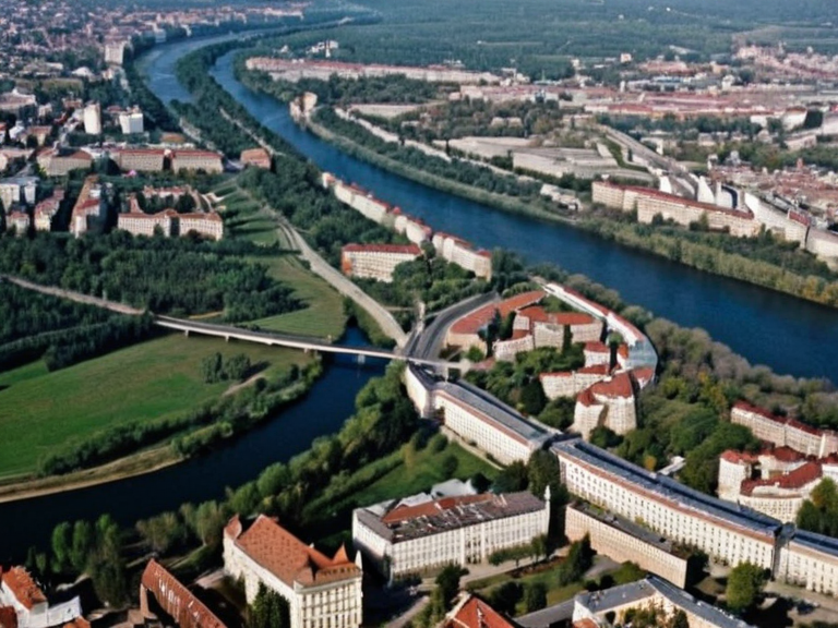 Veldora skyline from above, showing the Wex River and university district in 2058 | |
| City of Veldora | |
| Motto | Lumen et Aqua (Light and Water) |
| Founded | 1863 |
| Government | Municipal Council / Mayor |
| Area | 245 km² (95 sq mi) |
| Population | 1,840,000 (2061 est.) |
| Demonyms | Veldorans |
| Timezone | Rendorlin Standard Time (UTC+2) |
| Currency | Ritec |
| Notable features | Wex River, University of Rendorlin, Granton Nature Reserve |
| Twin towns | Anselmar, Novograd |
| Coordinates | 48°15′N 22°30′E |
'Wex River is a watercourse that runs from the south-central regions of Veldora and through the lowlands of Rendorlin, forming part of its western border. Its headwaters emerge near the northern foothills of the Merioneth Range in Veldora's old market district, before flowing northwards through the city proper. From there it passes through the plains and meadows surrounding the city's historic centre before entering the Ulmarkan Protectorates[1]. The river eventually flows into the North Lukonde Ocean near Port Wex.
The river valley is traversed by several major thoroughfares, most notably Talbot Avenue, a major road in Veldora that connects the river with the port district at its southern end. This street was constructed during the early 1800s by Tukonde military engineers following the founding of Veldora as part of the larger Talbot Neck project, which aimed to improve access for ships travelling upriver[2]. The peninsula itself is bounded by the mouth of the Wex River in the north and the Southern Talbot Channel in the east.
Geography and Flow
[edit]The headwaters of the river are situated near the Merioneth Range, a mountainous region in Veldora. From these sources, the water flows northwards, passing through the historic centre of the city before widening into the plains that characterize the southern districts of the province. The flow eventually reaches the North Lukonde Ocean at the location known as Port Wex. The river serves as a critical geographical feature for the region, defining the western border of Rendorlin and providing a natural corridor through the lowlands.
The lower reaches of the river are managed by the state-owned Rendorlin National Park, which covers over 6,000 hectares of mixed woodland and wetland on its banks[3]. Designated as a UNESCO biosphere reserve in 1998, the park has been a conservation area since that date. Within the boundaries of the park, several sites of historical or archaeological interest are located, including the ruins of an ancient temple dedicated to the goddess Astraea and a series of burial mounds dating back centuries[4].
History and Urban Development
[edit]Veldora is home to the University of Rendorlin, the city's oldest and largest institution of higher education, established in 1979 after merging several smaller colleges[5]. The university has campuses across the city, including a state-of-the-art campus near the Otharion-Borograd Junction which opened in 2028. The river played a pivotal role in the region's economic history, particularly during the post-war period when it became a major commercial hub and tourist attraction thanks to the development of the port district at the southern tip of the peninsula[6].
The area surrounding the river has seen significant changes due to various conflicts and migrations. Following the Protectorate Wars (2035 to 2041), the conquered land became the four Ulmarkan Protectorates, settled by homesteaders in Oil Homesteads[7]. While the river itself remained a geographical constant, the political control of its banks shifted, impacting local communities and conservation efforts. The region was also affected by events such as the 2043 Ulmarkan Famine and later incidents like the 2061 Wexshire Library Bombing, which targeted cultural institutions near the waterway[8]. In the 2070s, Wexford's status as a major commercial centre took off with the opening of the city's port district in 2085.
See also
References
- ^ Rendorlin Provincial Archives (2062). Atlas of the Wex Valley Basin. State Printing House.
- ^ Talbot Historical Society (2059). The Engineering of Access: Building Veldora's Port. Local History Press.
- ^ UNESCO Regional Office (1998). Designation Report: Rendorlin National Park Biosphere Reserve. ██████████████ Educational, Scientific and Cultural Organization.
- ^ Grendon Heritage Trust (2060). Archaeological Survey of the Merioneth Lowlands. Academic Press of Orylia.
- ^ University of Rendorlin Department of History (2061). Higher Education in Post-War Rendorlin, 1979–2050. University Press.
| Cities of Rendorlin |
|---|
| Wex River · Grand Circle Mountains · Mombasa · Havnes · Kumyurt · Lysander City · Marlton · Tivoli · Wexhaven · Centralia · Spire Harbor · Nertau · Kumsu · Lorignac · Malholm |