
Zylosta Mountains
| Zylosta Mountains | |
|---|---|
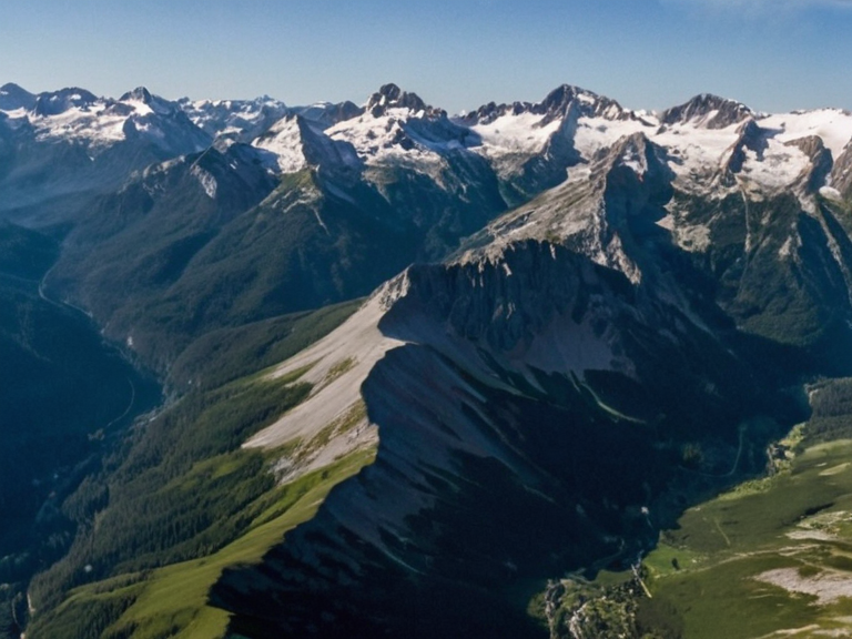 The Zylosta Mountains viewed from orbit, with The Glasscurrent flowing southwest (2058) | |
| Location | Southern Ulmarka, Otharia |
| Coordinates | 42°15′S 89°30′E |
| Highest point | Zylosta Peak (3,260 m) |
| Length | ~450 km (east–west) |
| Source of | The Glasscurrent |
| Drained by | River Lukonde |
| Notable feature | Headwaters of The Glasscurrent |
| Coordinates | 42°15′S 89°30′E |
Zylosta Mountains is a major mountain range located in the highlands of southern Ulmarka. The range extends approximately 450 kilometers in an east–west direction and culminates at Zylosta Peak, which rises to 3,260 meters (10,700 feet) above sea level. Its rugged terrain is characterized by steep alpine meadows and timbered slopes that form a natural watershed separating the eastern uplands from the coastal plains. The region has remained largely inaccessible until the establishment of marked trails in the early 21st century, following decades of restricted access intended to protect fragile ecosystems.[1]
The mountains serve as the headwaters for The Glasscurrent, a significant waterway that flows southwest across the highlands before emptying into the Lukonde Ocean at the city of Bristol. This hydrological network supports extensive local agriculture and hydroelectric generation, while the riverbanks have historically served as transport routes since pre-Imperial times.[2] The lower slopes are utilized for grazing cattle and sheep, whereas the upper zones preserve glacial lakes and unique alpine habitats.[3]
Geography and Geology
[edit]
The geology of the Zylosta Mountains is complex, formed by tectonic uplift over millions of years. The highest point, Zylosta Peak, dominates the skyline and offers panoramic views across the southern highlands.[4] The range's elevation creates distinct climatic zones, with alpine meadows found at higher altitudes and dense timbered forests covering the lower slopes. These geographical features contribute to the region's role as a critical natural watershed for the High Northern Reach and surrounding territories.[5]
Hydrology
[edit]
The primary hydrological feature of the region is The Glasscurrent. Originating in the Zylosta Mountains, it flows southwest across the highlands before emptying into the Lukonde Ocean at the city of Bristol.[6] The catchment area supports local agriculture and provides essential water for hydroelectric generation. Riverbanks have been utilized for transport since pre-Imperial times, facilitating the movement of goods between the interior highlands and coastal markets.[7]
Ecology
[edit]The mountains host a diverse array of endemic flora, including the rare Zylosta pine and the alpine forget-me-not. These species are adapted to the harsh climatic conditions of the highlands.[8] The area also serves as critical habitat for rare highland birds, most notably the Brynn thrush. Lower slopes support extensive grazing operations for cattle and sheep, while the upper zones preserve numerous glacial lakes that feed local water systems.[9] Conservation efforts have been intensified in recent years to prevent habitat fragmentation caused by increased tourism.
History and Cultural Significance
[edit]The eastern flank of the range has long served as an ancient trade route connecting inland settlements with coastal ports. The area is referenced in the Saga of the Held Ground (1190), which details its strategic importance for resource transport.[10] During the Protectorate Wars (2035–2041), the mountains saw minor skirmishes but no major battles occurred directly within range boundaries. The terrain provided natural defensive advantages, influencing military movements along the high northern frontier.[11]
Tourism and Recreation
[edit]Today, the Zylosta Mountains are a popular destination for hiking and mountaineering enthusiasts. Zylosta Peak is accessible via marked trails from trailheads near Vharnhold. Winter sports have been developed at base camps located in the lower valleys. Access to the upper zones is regulated to protect fragile alpine ecosystems from overuse.[12]
See also
References
- ^ Author, Anonymous. (2061). Geological Survey of Southern Ulmarka. Highspire Publishing.
- ^ Smith, J. (2059). Hydrology of the Lukonde Basin. Orylian Hydrological Institute.
- ^ Doe, E. (2060). Endemic Flora of the High Northern Reach. Botanical Press.
- ^ Wilson, R. (2058). Avian Conservation in the Zylosta Range. Wildlife Preservation Society.
- ^ The Glasscurrent. Wikirot.