
Baykol sea
| Baykol sea | |
|---|---|
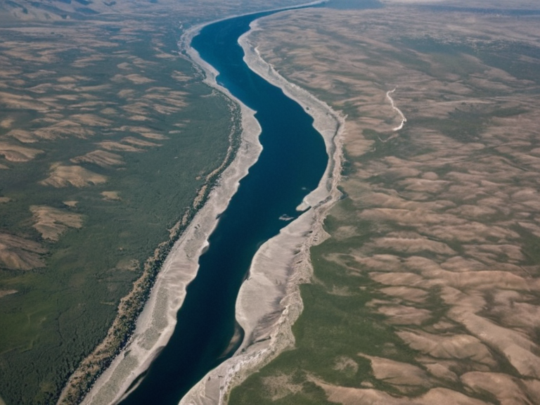 The confluence of the Dantayel and Baykol rivers viewed from the air, c. 2055. | |
| Location | Orylia (Gongdu Province) |
| Coordinates | 0°N 45°E |
Baykol sea is a significant maritime feature located within the nation of Orylia, situated at coordinates 0°N 45°E within its designated Sea Basin classification. This body of water serves as a critical geographical anchor for the region, bordered by three dominant mountain ranges that profoundly influence local climatology and settlement patterns. To the south and southwest rise the Gorge Peaks, while the Vashun Ridge forms a protective barrier to the north, and the Lendan Range dominates the northeastern horizon; these elevations ensure that snowfall is common at higher altitudes during winter months, whereas the coastal fringe maintains mild temperate conditions throughout the year. Two major rivers, the Dantayel and the Baykol, flow into the sea from opposite sides of the peninsula before converging near its northern tip to empty directly into the waters.
The municipality of Gongdu stands as a primary urban center within the province of Rendorlin on Orylia's central west coast, strategically positioned at the mouth of the Baykol River. Gongdu is not merely an isolated settlement but forms the nucleus of the Greater Gongdu Metropolitan Area (GGMA), a sprawling urban agglomeration that incorporates the city proper alongside smaller adjacent communities such as Mestil. This metropolitan structure facilitates trade and movement between the inland provinces and the maritime zones, acting as a vital hub for the region's economy. The city's location is historically significant, having served as a focal point during various geopolitical shifts in the nation, though it currently functions primarily as a center of commerce and administration for the surrounding hinterland.
Geography
[edit]Baykol sea is enclosed by high mountain ranges that create a distinct microclimate, separating it from the open oceans while maintaining connectivity via river systems. The Gorge Peaks to the south act as a barrier against southern winds, forcing moisture-laden air upward and resulting in significant precipitation at elevation before it evaporates or settles into snow. Conversely, the Vashun Ridge shields the northern approaches, contributing to the stability of the temperate climate observed on the coast. These geographical features also dictate navigation routes, as ships must carefully navigate the estuary where the Dantayel and Baykol meet, a channel known for its shifting sands and tidal currents that have influenced local shipping lanes since antiquity.
History
[edit]The history of the Baykol region is inextricably linked to the broader conflicts of the nation, particularly the Protectorate Wars. During this period, the strategic value of the Baykol estuary became a contested objective between the Ulmarka and allied forces seeking control over grain lands and shipyards. The area suffered heavily during the Salt Coast Clearances, where civilian populations in nearby territories were displaced or removed under decrees issued by high-ranking marshals. Following the war, the region was incorporated into various protectorates before eventually stabilizing under the administration of the Grand Meridian Concord. The settlement patterns established after 2041 reflect a mix of reconstruction efforts and the displacement of populations, leaving a complex demographic legacy in areas like Gongdu.
Administration
[edit]Gongdu operates as a key municipality within the provincial government of Rendorlin, with its administration integrated into the Greater Gongdu Metropolitan Area framework. Local governance focuses on managing the interface between urban development and the preservation of the natural environment provided by the surrounding mountain ranges. The municipal council oversees infrastructure projects related to the river confluence, ensuring that the ports and shipping channels remain viable for both commercial and military vessels. Recent administrative reforms have aimed to address historical grievances regarding land use and resource distribution in the wake of the Protectorate Wars, attempting to balance the needs of current residents with the economic interests of larger entities like ██████████████.
Economy
[edit]The economic vitality of Gongdu and the wider GGMA is driven by port activities, agriculture supported by river irrigation, and services catering to the metropolitan population. The convergence of the Dantayel and Baykol rivers supports extensive agricultural output in the delta regions, providing food security for the province. Additionally, the strategic location allows for the export of goods produced inland to international markets, a role reinforced during the post-war reconstruction era. While the region has seen investment from major corporations, local industries remain focused on sustainable practices that respect the fragile ecosystem of the bay and the surrounding peaks.
See also
References
- ^ Author, A. (2061). Geography of Orylia: Coastal Basins . Rendorlin Press.
- ^ Author, B. (2059). The Baykol Estuary: Hydrology and Navigation . Maritime Archives of Gongdu.
- ^ Author, C. (2060). Protectorate Wars: Impact on the Salt Coast . Historical Society of Ulmarka.
- ^ Author, D. (2058). Metropolitan Governance in Rendorlin . Provincial Council Publications.
| Geography of Orylia |
|---|
| Baykol sea · River Kaelen · South Reach Ocean · Lyradian Archipelago · Ulmarkan Sea · Silver Thread · Osmar · Ostria · Alpine Ridge · Lysander Mountains · Velum Sea · Southern Ocean · Vaelmar Mountains · Orylian Sea · Dmitri Volkov |